Skip to search
Skip to main content
Skip to first result
Search
You Searched For
Date
1800 - 1849
"Authors"
Genre
Maps
Resource Type
Maps, Atlases & Globes
Language
English
Date Created
1800 to 1849
New Search
Search Results
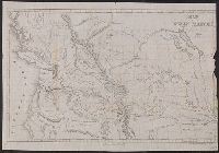
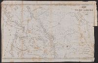
Creator:
author .
Published / Created:
1845.
Call Number:
80 1844A
Image Count:
1
Resource Type:
Maps, Atlases & Globes
Alternative Title:
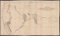
[U.S. 28th Cong., 2d sess. Senate. Ex. doc. ; 174] and Map of an exploring expedition to the Rocky Mountains in the year 1842, and to Oregon & North California in the years 1843-44.
Description:
"Map of an exploring expedition to the Rocky mountains in the year 1842, and to Oregon and North California in the years 1843-44" usually bound at end of volume has been removed from the KSL copy and filed in the Map Collection of BEIN. and Published by Henry Polkinghorn at Washington under title: "Narrative" instead of report.
Publisher:
Gales and Seaton, Printers,
Subject (Geographic):
Pacific States., Rocky Mountains., United States--Exploring expeditions., and West (U.S.)--Description and travel.
Subject (Name):
Hall, James, 1811-1898., Torrey, John, 1796-1873., and United States. Army. Corps of Topographical Engineers.
Subject (Topic):
Geology--West (U.S.), Geomorphology--West (U.S.), and Paleontology--West (U.S.)
Found in:
Beinecke Rare Book and Manuscript Library > Report of the exploring expedition to the Rocky Mountains in the year 1842, and to Oregon and north California in the years 1843-'44 / By Brevet Captain J. C. Frémont, of the topographical engineers under the orders of Col. J. J. Abert, Chief of the Topographical Bureau ; printed by order of the Senate of the United States.
Creator:
Published / Created:
1844 February 15
Call Number:
70 1844
Container / Volume:
BRBL_00359
Image Count:
1
Resource Type:
Maps, Atlases & Globes
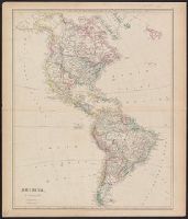
Description:
From the author's London atlas of
Publisher:
J. Arrowsmith, 10 Soho Square,
Subject (Geographic):
America--Maps
Subject (Name):
Arrowsmith, John, 1790-1873. London atlas of universal geography
Found in:
Beinecke Rare Book and Manuscript Library > America / by J. Arrowsmith.
Creator:
author
Published / Created:
[1834]
Call Number:
761 1834
Container / Volume:
BRBL_00447
Image Count:
1
Resource Type:
Maps, Atlases & Globes
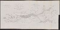
Description:
"Outline drawn and corrected from Greenleaf's state map of Maine by Lieuts. Ward and Cooper.", Top left corner: "Doc. 144.", and With north oriented towards the right.
Publisher:
[United States Army Corps of Engineers],
Subject (Geographic):
Kennebec River (Me.)--Maps
Subject (Name):
Bache, Hartman, 1797-1872, Cooper, J. F, Greenleaf, Moses, 1777-1834, and Ward, G. W
Found in:
Beinecke Rare Book and Manuscript Library > The Kennebec River and adjacent country : shewing the routes examined for a road from Augusta to the Canada line in the direction of Quebec / reconnaissance made in 1834 by Hartman Bache, T.E. & B.T. Major, assisted by G.W. Ward, 2nd Lt. 2nd Arty. and J.F
Creator:
Published / Created:
1801
Call Number:
491 1801
Container / Volume:
BRBL_00269
Image Count:
1
Resource Type:
Maps, Atlases & Globes
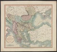
Description:
Appears in the author's Cary's new
Publisher:
J. Cary, engraver & map-seller, no. 181 Strand,
Subject (Geographic):
Balkan Peninsula--Maps and Thrace, Eastern (Turkey)--Maps
Subject (Name):
Cary, John, ca. 1754-1835. Cary's new universal atlas
Found in:
Beinecke Rare Book and Manuscript Library > A new map of Turkey in Europe, divided into its provinces, from the best authorities / by John Cary, engraver.
Creator:
Published / Created:
1816]
Call Number:
795hc N47 1815B
Container / Volume:
BRBL_00523
Image Count:
1
Resource Type:
Maps, Atlases & Globes
Description:
From the author's Historical memoir of
Publisher:
J. Conrad and co.,
Subject (Geographic):
United States--History--War of 1812--Maps
Subject (Name):
Latour, Arsène Lacarrière, 1778-1837. Historical memoir of the war in West Florida and Louisiana in 1814-15
Subject (Topic):
New Orleans, Battle of, New Orleans, La., 1815--Maps
Found in:
Beinecke Rare Book and Manuscript Library > Map shewing the landing of the British Army : its several encampments and fortifications on the Mississippi and the works they erected on their retreat, also the different posts, encampments and fortifications made by the several corps of the American Arm
Creator:
Published / Created:
1838
Call Number:
80 1838A
Container / Volume:
BRBL_00532
Image Count:
1
Resource Type:
Maps, Atlases & Globes
Description:
From the author's Journal of an
Publisher:
M.M. Peabody,
Subject (Geographic):
Northwest, Pacific--Maps and Oregon--Maps
Subject (Name):
Parker, Samuel, 1779-1866. Journal of an exploring tour beyond the Rocky mountains and Peabody, M. M
Subject (Topic):
Indians of North America--Northwest, Pacific--Maps
Found in:
Beinecke Rare Book and Manuscript Library > Map of Oregon territory / by Samuel Parker.
Creator:
Published / Created:
[1845]
Call Number:
80 1841B
Container / Volume:
BRBL_00533
Image Count:
1
Resource Type:
Maps, Atlases & Globes
Alternative Title:
Columbia River, reduced from a survey made by the U.S. Ex. Ex.
Description:
Appears in the author's Narrative of
Publisher:
J.H. Young : and Sherman & Smith,
Subject (Geographic):
Columbia River--Maps, Northwest, Pacific--Maps, and Oregon--Maps
Subject (Name):
Sherman & Smith, United States Exploring Expedition (1838-1842), and Young, J. H. (James Hamilton)
Found in:
Beinecke Rare Book and Manuscript Library > Map of the Oregon Territory / by the U.S. Ex. Ex., Charles Wilkes, 1841.
Branch:v1.61.6 ,Deployed:2024-06-12T09:55:36-04:00