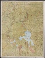
Yellowstone National Park, Puget Sound, and Alaska, via Northern Pacific Railway
Description:
2 maps, text, distance table, and ill. on verso., Copyright: Poole Bros., Chicago., Date inferred from verso text., In top margin: Northern Pacific Railway., On back panel: Northern Pacific, Yellowstone Park line, Puget Sound and Alaska., Panel title., and Relief shown by shading and spot heights.
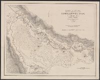
"1871.", "Approximate latitude of Park Pt., 44⁰23ʹ, approximate longitude of Park Pt., 110⁰20ʹ.", "Soundings are in fathoms.", At head of title: Department of the Interior, U.S. Geological Survey of the Territories., From the Survey's 5th annual report., and Relief shown by hachures and spot heights. Depths shown by soundings.
Publisher:
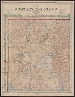
Geological Survey of the Territories,
Subject (Geographic):
Yellowstone Lake (Wyo.)--Maps and Yellowstone National Park--Maps
Subject (Name):
Elliott, Henry Wood, 1846-1930, Geological Survey of the Territories (U.S.), Hayden, F. V. (Ferdinand Vandeveer), 1829-1887, and Schönborn, A
National Geographic Society (U.S.). Cartographic Division
Published / Created:
c1989.
Call Number:
833 Y38 1989
Container / Volume:
BRBL_00584
Image Count:
2
Resource Type:
Maps, Atlases & Globes
Alternative Title:
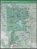
Special places of the world map series
Description:
"Supplement to the National Geographic, February 1989, page 216A, vol. 175, no.2-Yellowstone/Grand Teton.", Panel title., Relief shown by shading and spot heights., and Text, maps and col. ill. on verso.
Publisher:
The Society,
Subject (Geographic):
Grand Teton National Park (Wyo.)--Maps and Yellowstone National Park--Maps