

- None1
You Searched For
1 - 5 of 5
Search Results
2.

- Creator:
- Leake, John, cartographer
- Published / Created:
- [1723]
- Call Number:
- 32 L84 1667A
- Image Count:
- 1
- Resource Type:
- cartographic image
- Description:
- BAC: Hand colored. British Art Center copy bound with: To Martin Folkes ... this plan of the cities of London and Westminster and borough of Southwark. London : John Tinney, 1749., BEIN 32 L84 1667A: Imperfect: eastern sheet wanting. Manuscript annotation: This is apparently 1/5 [1/2?] of the so-called Faithorne map, published by Newcourt after Fire of 1666 and purporting to show London in 1658., Shows extent of Great Fire of 1666., Engraved by George Vertue, probably from Leake's original sheets published in 1667, and dedicated to the Society of Antiquaries., Coordinates not present on map and are approximated., and Inset along top of map are 7 views of buildings. Also inset is a small index map, with title: A plan of the city of London and Westminster.
- Publisher:
- George Vertue
- Subject (Geographic):
- London (England)
- Subject (Topic):
- Maps and Description and travel
- Found in:
- Beinecke Rare Book and Manuscript Library > An exact surveigh of the streets, lanes and churches comprehend[e]d within the ruins of the city of London : first described in six plats 10 Decemr. Ao Dom. 1666 : by the order & directions of the Right Honorable the Lord Mayor, aldermen, & common councell of the said city
3.

- Call Number:
- OSB MSS 155
- Container / Volume:
- Box
- Image Count:
- 30
- Abstract:
- Manuscript documents and letters, illustrating the daily life and responsibilities of sea captains in the 18th and early 19th centuries. The collection includes documents relating to Captain Robert Poultney in Jamaica and letters on personal and naval matters addressed to Captain John Wainwright. Also included are descriptions of coastal areas and navigation hazzards, documents relating to obtaining supplies, a ship's newsletter, and a colored map ("Rochfort et les Environs").
- Description:
- Robert Poultney was the captain of the ship Loretta in Jamaica in 1762-1764., John Wainwright of the Royal Navy served in the East Indies and the Mediterranean, fought throughout the Napoleonic Wars, and is remembered for the destruction of the pirate town Ras-al-Kayma while captain of the ship Chiffonne., and In English, with one letter in French.
- Subject (Geographic):
- Mediterranean Region and Brittany (France)
- Subject (Name):
- Poultney, Robert., Wainwright, John, Captain., Chiffonne (Ship), Great Britain. Royal Navy, and Loretta (Ship)
- Subject (Topic):
- Officers, Sea life, Aids to navigation, Coasts, Navigation, Seafaring life, Ship captains, and Description and travel
- Found in:
- Beinecke Rare Book and Manuscript Library > Documents concerning ship captains and shipping, 1762-circa 1809
4.

- Creator:
- California Immigrant Union
- Published / Created:
- [between 1870 and 1877]
- Call Number:
- BrSides Zc72 870ce
- Image Count:
- 3
- Description:
- BEIN WA MSS S-3931 M2231: With manuscript letter from Charles Maclay to Newton Booth, dated 3 November 1877. This copy is also cataloged separately as a manuscript with title: Charles Maclay letter, San Fernando, California, to Governor Newton Booth, Sacramento, California, 1877 November 3., Brochure announcing land for sale in San Fernando, Calif., including a map., Title from caption on p. [2]., "San Francisco, [blank] 187[blank]"--P. [1]., Beinecke Library copy includes manuscript letter dated Nov. 3, 1877., "Wm. H. Martin, general agent, San Francisco, Cal."--P. [1]., "Map of the town of San Fernando and the Maclay San Fernando Ranch": p. [4]., and Page [1] has letterhead for California Immigrant Union and large blank space for correspondence.
- Publisher:
- California Immigrant Union
- Subject (Geographic):
- California, San Fernando., San Fernando (Calif.), and California, Southern
- Subject (Topic):
- Real property and Description and travel
- Found in:
- Beinecke Rare Book and Manuscript Library > Land for sale : 1,000 acres in the town of San Fernando, 36,000 acres in Maclay's San Fernando Ranch : terms easy, title perfect
5.
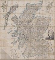
- Creator:
- Ainslie, John (Surveyor)
- Published / Created:
- [1800]
- Call Number:
- Folio 15 800Ai
- Image Count:
- 1
- Resource Type:
- cartographic image
- Alternative Title:
- Scotland drawn and engraved from a series of angles and astronomical observations
- Description:
- Title from cartouche., Engraved throughout., Relief shown by contour lines and pictures., Scale of miles 69 1/2 to a degree., Another imprint: "Published according to Act of Parliament Jan. 1st. 1789 by John Ainslie ... and William Faden ..." at bottom of sheet., Inset maps: "Shetland Islands laid down upon a less scale than the map ... "; "A Map of the Orkney Islands ...", Distance tables and lists of heights of hills and roads from Edinburgh to London., Edinburgh meridian, with note of degrees from Greenwich., Title cartouche shows men fishing and herding cattle, with sheep goats and foliage., Six compass roses., This issue not in Chubb, T. Printed maps in the atlases of Great Britain and Ireland., and Scotland.
- Publisher:
- Printed and sold by the proprietor Thomas Brown, North Bridge Street, Edinburgh and Publish'd according to Act of Parliament with improvements till 1800 by Thomas Brown ... Edinburgh and William Faden ... London
- Subject (Geographic):
- Scotland, Orkney (Scotland), Shetland (Scotland), Scotland., Orkney., and Shetland.
- Subject (Topic):
- Description and travel and Travel
- Found in:
- Lewis Walpole Library > Scotland : drawn and engrav'd from a series of angles and astronomical observations