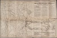
Ground plan of Camp Supply. and Ground plan of Fort Sill.
Description:
Includes "Ground plan of Fort Sill" and "Ground plan of Camp Supply.", Library's copy annotated in blue ink to show routes and notable locations., and Relief shown by hachures and spot heights.
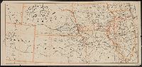
Highway map, St. Louis and Standard Oil Company (Indiana), road map, St. Louis and vicinity
Description:
At head of title: Standard Oil Company (Indiana), In lower right: X.3518, Indexed., Maps of downtown St. Louis, ill., and text on verso., and Relief shown by hachures.
Publisher:
Rand McNally,
Subject (Geographic):
Saint Louis (Mo.)--Maps and Saint Louis Metropolitan Area (Mo.)--Maps
"58" and "59.", "Entered according to act of C, Below title: Published by Johnson and Ward., Prime meridian: Greenwich and Washington., Prime meridians: Greenwich and Washington., and Tables of "Historical and statistical view of the United States, 1860" on verso.