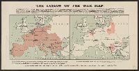
Compares the amount of territory occupied by the Allies versus that of the Central Powers., In lower margin: "If it is indeed true that the map is the test of Germany's success, then Germany has already irrevocably lost the war.", and Includes additional text.
Publisher:
Stanford's Geogl. Estabt.,
Subject (Geographic):
Europe--Administrative and political divisions--History--20th century--Maps, Europe--Maps, Germany--Administrative and political divisions--History--20th century--Maps, and Germany--Maps
Subject (Topic):
World War, 1914-1918--Europe--Maps and World War, 1914-1918--Germany--Maps
National Geographic Society (U.S.). Cartographic Division
Published / Created:
c1992.
Call Number:
739 1992
Container / Volume:
BRBL_00389
Image Count:
2
Resource Type:
Maps, Atlases & Globes
Alternative Title:
British Columbia.
Description:
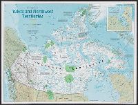
"Design: Charles W. Berry ; art: Tom NcNeely ; research: Linda R. Kriete, Michael Nicolls, Andrew J. Wahll ...", Alternate title: British Columbia., Includes historical notes and inse, and Relief shown by shading and spot heights. Depths shown by gradient tints.
"Supplement to National Geographic, September 1997." and On verso: 1. To 1576, arrival of the first peoples -- 2. 1576 to 1870, exploration and the fur trade -- 3. 1870 to 1939, Canada's northward expansion -- 4. 1939 to present, the modern north : roads, rad
Publisher:
National Geographic Society,
Subject (Geographic):
Northwest Territories--History--Maps and Yukon--History--Maps
Allan, A., Capt Beatson, Alexander, 1759-1833 Harmar, Thomas Rennell, James, 1742-1830, creator
Published / Created:
1792 February 21
Call Number:
1982 Folio 10
Image Count:
1
Description:
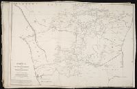
Compiled from the original maps, drawn by Capt. A. Beatson and Capt. A. Allan ; with some particulars added in explanation by J. Rennell ; plan work by I. Walker ; writing by T. Harmar., Map with relief shown pictorially., No. 33 of 43 maps bound together in composite atlas., and Scale [ca. 1:750,000].
Publisher:
J. Rennell
Subject (Geographic):
India, South --History, Military --Maps --Early works to 1800
Charts and title pages in English, text in Dutch., Map oriented with North at bottom left., and Volvelle on p. [17].
Publisher:
Jodocus Hondius excudit,
Subject (Geographic):
Europe --Maps --Early works to 1800, Great Britain --Maps --Early works to 1800, Netherlands --Maps --Early works to 1800, and North Sea --Maps --Early works to 1800