Skip to search
Skip to main content
Skip to first result
Search
You Searched For
Genre
Maps
Language
Latin
Search Results
Creator:
Published / Created:
1522?]
Call Number:
66 1522
Container / Volume:
BRBL_00347
Image Count:
2
Resource Type:
Maps, Atlases & Globes
Alternative Title:
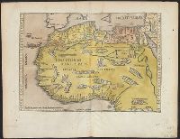
Partis Aphricae, et tabula secunde partis Aphricae
Description:
Title supplied by cataloger. and Verso: Latin text, Masonic square and compasses.
Subject (Geographic):
Africa, North--Maps--Early works to 1800
Subject (Name):
Freemasons--Insignia--Maps--Early works to 1800
Found in:
Beinecke Rare Book and Manuscript Library > [Map of northern Africa].
Published / Created:
[1700?]
Call Number:
53 1700A
Container / Volume:
BRBL_00283
Image Count:
1
Resource Type:
Maps, Atlases & Globes
Subject (Geographic):
Middle East--Maps--Early works to 1800
Found in:
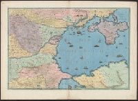
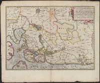
Beinecke Rare Book and Manuscript Library > [Map of southeast Europe and the Black Sea] C. Berey Sculp.
Creator:
Published / Created:
Undated
Call Number:
Taylor 216A
Collection Title:
Iohn Huighen van Linschoten, his Discours of Voyages into ye Easte & West Indies : deuided into
Image Count:
1
Description:
Bound in following title page of second book. and Map has small tear at bottom fold in center.
Subject (Geographic):
Africa --Maps --Early works to 1800, Cape of Good Hope --Maps, Congo (Democratic Republic) --Maps, and Madagascar --Maps --Early works to 1800
Subject (Name):
Wolfe, John, d. 1601, printer
Subject (Topic):
Voyages and travels --Early works to 1800
Collection Created:
[London] : Printed at London by [John Windet for] Iohn Wolfe, printer to ye Honorable Cittie of London, [1598]
Found in:
Beinecke Rare Book and Manuscript Library > [Map of southern Africa and Madagascar]
Creator:
Published / Created:
1652?]
Call Number:
19 1657
Container / Volume:
BRBL_00682
Image Count:
1
Resource Type:
Maps, Atlases & Globes
Description:
Cross Collection no. 60., From Janssonius's Niewen atlas ... Amstelodami : Apud Ioannem Ianssonium, 1652., Hand col. Mounted on linen., Includes marginal ill., Relief shown pictorially., Title supplied by cataloger., and Variant of Hondius' Polus Antarcticus, 1638.
Publisher:
J. Jansson,
Subject (Geographic):
Antarctica--Maps--Early works to 1800 and Southern Hemisphere--Maps--Early works to 1800
Subject (Name):
Jansson, Jan, 1588-1664. Atlas novus. Dutch
Found in:
Beinecke Rare Book and Manuscript Library > [Polus Antarcticus].
Creator:
Published / Created:
[1601]
Call Number:
Manuscript 49cea 1601
Image Count:
2
Resource Type:
cartographic image
Description:
Title devised by cataloger., "Vinc[enti]us demetrei Volcius Rachuseus. Fecit interra Liiburni die 24 Maius 1601.", With blue cloth tie at left edge., Color: red, blue, and some gold., With four compass roses., and Coordinates not present on map and are approximated.
Subject (Geographic):
Mediterranean Sea
Subject (Topic):
Nautical charts
Found in:
Beinecke Rare Book and Manuscript Library > [Portolan chart of the Mediterranean Sea].
Published / Created:
1754
Call Number:
88 P96 1754
Container / Volume:
BRBL_00647
Image Count:
1
Resource Type:
Maps, Atlases & Globes
Description:
For more information see the back of the catalogue card.
Subject (Geographic):
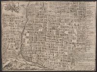
Mexico--Maps--Early works to 1800
Found in:
Beinecke Rare Book and Manuscript Library > [Puebla de los Angeles: Engraved plan of the town by] Jph. ortiz Carnero sculpe Altixco [after] Bs Joseph Marianus a Medina.
Published / Created:
MDXCVIII [1598]
Call Number:
Taylor 193 1-2
Collection Title:
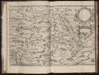
Regnum Congo hoc est vera descriptio regni Africani : quod tam ab incolis quam Lusitanis Congus
Image Count:
1
Description:
Map has two identical small holes on both the top left and top right corners. and Third of three maps bound following leaf [4] of preface, continued from previous leaves.
Subject (Geographic):
Africa --Description and travel and Ethiopia
Collection Created:
Francofurti : Excudebat VVolffgangus Richter, impensis Io. Theo. & Io. Israel. de Bry, frat., MDXCVIII [1598]
Found in:
Beinecke Rare Book and Manuscript Library > [Tabulam hanc Aegypti ... sheet 2]
Call Number:
Taylor 58
Collection Title:
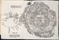
Praeclara Ferdinadi. Cortesii de noua maris Oceani Hyspania narratio ... Carolo Romanoru imperatori
Image Count:
1
Description:
Preceding Argumentum Libri. and Teaching resource: Professor John Mack Faragher, History 141: The American West.
Subject (Geographic):
Mexico City (Mexico) and Mexico --History --Conquest, 1519-1540
Subject (Name):
Savorgnano, Pietro
Collection Created:
Norimberga, 1524
Found in:
Beinecke Rare Book and Manuscript Library > [Untitled map of Tenochtitlan]
Published / Created:
[1605]
Call Number:
3361 1605
Container / Volume:
BRBL_00088
Image Count:
2
Resource Type:
Maps, Atlases & Globes
Description:
Preliminary record. and Verso: Text.
Subject (Geographic):
West Flanders (Belgium)--Maps--Early works to 1800
Found in:
Beinecke Rare Book and Manuscript Library > [West Flanders] Petrus Koerius coelavit.
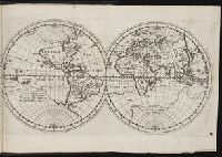
Published / Created:
[Ca. 1612]
Call Number:
Taylor 258
Collection Title:
Descriptio ac delineatio geographica detectionis freti, sive, transitus ad occasum supra terras
Image Count:
1
Description:
Bound in after p. [8]., Map folded irregularly., Printed on recto in lower right corner: B., and Scale [ca. 1:160,000,000].
Subject (Name):
Quieros, Pedro Fernandes de, d. 1615
Subject (Topic):
World maps --Early works to 1800
Collection Created:
Amsterodami Ex officina Hesse lij Gerardi. Anno 1613
Found in:
Beinecke Rare Book and Manuscript Library > [World map]
Branch:v1.68.2 ,Deployed:2025-06-12T06:59:32-04:00