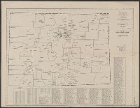
Index of cities and towns with elevation keyed to map., Relief shown by hachures and shading., Shows railroads, wagon roads, trails, county boundaries, ditches, land offices, forest, water, irrigation districts and land grants., and Shows township and range grid.
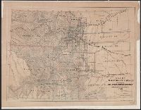
Below title: Map no. 405., Copyright: American Map Company, New York., Date from stamp: Mar 20 1931., Indexed., and Shows county seats and boundaries, with few other towns.
Publisher:
American Map Company,
Subject (Geographic):
Colorado--Administrative and political divisions--Maps and Colorado--Maps
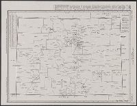
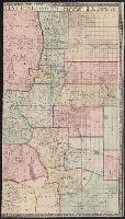
"Engraved and indexed for use with the Rand McNally commercial atlas and marketing guide.", Date inferred from 1950 population table of counties., and Indexed.
Publisher:
The Company,
Subject (Geographic):
Colorado--Administrative and political divisions--Maps and Colorado--Maps
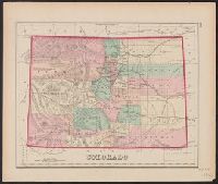
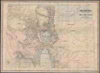
In upper right-hand margin: 132., Possibly from Gray's atlas of the United States. Philadelphia : Stedman, Brown & Lyon, 1874., Prime meridians: Greenwich and Washington., Relief shown by hachures., and Shows counties formed in 1874 (e.g., La Plata and Rio Grande), but does not show counties formed in 1877 (e.g., Custer or Gunnison).
Publisher:
Stedman, Brown & Lyon?,
Subject (Geographic):
Colorado--Maps
Subject (Name):
Gray, Ormando Willis. Gray's atlas of the United States and Stedman, Brown & Lyon
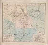
Geographical and geological map of the San Juan Mining Region, Colorado
Description:
"Entered according to Act of Congress, 1881 by A.F. Kibbe in the office of the Librarian of Congress at Washington.", Includes inset of "Map of the state of Colorado.", and Library's copy stamped in lower left margin: Library of Congress, city of Washington, copyright Jun 1, 1881, duplicate.
Publisher:
Geo. H. Adams & Son,
Subject (Geographic):
Colorado--Maps
Subject (Name):
American Photo-Lithographic Company and Geo. H. Adams & Son
Includes 7 town plans and "Map of Denver, Arapahoe Co., Colorado," "[Map of] Central City and vicinity," and "[Map of] Colorado." and Relief shown by hachures.
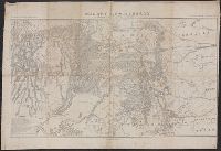
"Bvt. Maj. Gen. A.A. Humphreys, Chief of Engineers.", "Compiled under the direction of Bvt. Col. Wm. F. Merrill, Maj. Engrs, St. Louis, 1869.", Also shows parts of adjoining states., Includes list of "authorities.", and Relief shown by hachures.
Publisher:
s.n.,
Subject (Geographic):
Colorado--Maps and Utah--Maps
Subject (Name):
Humphreys, A. A. (Andrew Atkinson), 1810-1883, Merrill, Wm. F, R.P. Studley Co, and Sherman, William T. (William Tecumseh), 1820-1891