Skip to search
Skip to main content
Skip to first result
Search
You Searched For
Repository
Beinecke Rare Book and Manuscript Library
Genre
Maps
Resource Type
Maps, Atlases & Globes
Subject (Topic)
Railroads--West (U.S.)--Maps
New Search
Search Results
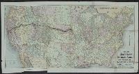
Creator:
Published / Created:
1868]
Call Number:
80gme 1869A
Container / Volume:
BRBL_00538
Image Count:
1
Resource Type:
Maps, Atlases & Globes
Description:
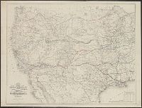
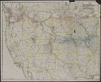
Includes distance tables., Relief shown by hachures., and Shows drainage, cities and towns, forts, military and Indian reservations, wagon roads, trails, routes of exploration, and the railroad network indicating finished, unfinished, and connecting lines.
Publisher:
s.n.,
Subject (Name):
Gedney, J. F and Southern Continental Railroad--Maps
Subject (Topic):
Railroads--West (U.S.)--Maps
Found in:
Beinecke Rare Book and Manuscript Library > Map of the route of the Southern Continental R.R. with connections from Kansas City Mo., Ft. Smith Ark. and Shreveport La., giving a general view of the recent surveys of the Kansas Pacific Railway Co., across the continent / made in 1867 & 1868, under th
Creator:
Published / Created:
1868]
Call Number:
80gme 1868
Container / Volume:
BRBL_00538
Image Count:
1
Resource Type:
Maps, Atlases & Globes
Description:
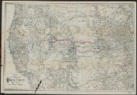
Includes distance table., Relief shown by hachures., and Shows drainage, cities and towns, forts, military and Indian reservations, wagon roads, trails, routes of exploration, and the railroad network indicating finished, unfinished, and connecting lines.
Publisher:
s.n.,
Subject (Name):
Gedney, J. F and Southern Continental Railroad--Maps
Subject (Topic):
Railroads--West (U.S.)--Maps
Found in:
Beinecke Rare Book and Manuscript Library > Map of the route of the Southern Continental R.R. with connections from Kansas City, Mo., Ft. Smith, Ark. and Shreveport, La. : giving a general view of recent surveys of the Kansas Pacific Railway Co. across the continent / made in 1867 & 1868 under the
Creator:
Published / Created:
1858?]
Call Number:
80 1857E
Container / Volume:
BRBL_00534
Image Count:
2
Resource Type:
Maps, Atlases & Globes
Description:
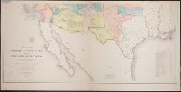
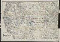
Includes "Note" and "Authorities.", Incorporates note and surveys added after Jan. 8, 1858., Relief shown by hachures and spot heights., and Shows Indian tribal locations, military posts, routes and dates of expeditions and surveys.
Publisher:
War Dept.,
Subject (Geographic):
West (U.S.)--Maps
Subject (Name):
Siebert, Selmar and United States. War Dept
Subject (Topic):
Pacific railroads--Explorations and surveys--Maps and Railroads--West (U.S.)--Maps
Found in:
Beinecke Rare Book and Manuscript Library > Map of the territory of the United States from the Mississippi to the Pacific Ocean : ordered by Jeff'n Davis, Secretary of War to accompany the reports of the explorations for a railroad route / compiled from authorized explorations and other reliable da
Published / Created:
[1928?]
Call Number:
80gme 1928
Container / Volume:
BRBL_00540
Image Count:
1
Resource Type:
Maps, Atlases & Globes
Description:
Covers western United States. and Date below legend: Dec. 31, 1928.
Publisher:
McGill-Warner Co.,
Subject (Name):
Chicago, Burlington & Quincy Railroad Company--Maps, Colorado and Southern Railway--Maps, McGill-Warner Co, Northern Pacific Railway Company--Maps, Spokane, Portland, and Seattle Railway--Maps, and Trinit
Subject (Topic):
Railroads--West (U.S.)--Maps
Found in:
Beinecke Rare Book and Manuscript Library > Map showing Northern Pacific Railway System, Chicago, Burlington & Quincy R.R. system, Spokane, Portland & Seattle Railway and its subsidiary lines ... Colorado & Southern Railway Lines ... [and] Trinity & Brazos Valley Railway.
Published / Created:
[1914?]
Call Number:
80gme 1914A
Container / Volume:
BRBL_00540
Image Count:
1
Resource Type:
Maps, Atlases & Globes
Description:
Covers western United States. and Date below legend: June 30, 1914.
Publisher:
McGill-Warner Co.,
Subject (Name):
Chicago, Burlington & Quincy Railroad Company--Maps, Colorado and Southern Railway--Maps, Great Northern Pacific Steamship Co.--Maps, McGill-Warner Co, Northern Pacific Railway Company--Maps, and Spokane
Subject (Topic):
Railroads--West (U.S.)--Maps
Found in:
Beinecke Rare Book and Manuscript Library > Map showing Northern Pacific Railway System, Chicago, Burlington & Quincy R.R. system, Spokane, Portland & Seattle Railway and its subsidiary lines ... Spokane & Inland Empire Railroad, Colorado & Southern Railway System, [and] Great Northern Pacific Stea
Published / Created:
[1912?]
Call Number:
80gme 1912
Container / Volume:
BRBL_00540
Image Count:
1
Resource Type:
Maps, Atlases & Globes
Description:
Covers western United States. and Date below legend: June 30, 1912.
Publisher:
McGill-Warner Co.,
Subject (Geographic):
West (U.S.)--Maps
Subject (Name):
Chicago, Burlington & Quincy Railroad Company--Maps, Colorado and Southern Railway--Maps, McGill-Warner Co, Northern Pacific Railway Company--Maps, Sp, and Spokane and Inland Empire Railroad Company--Maps
Subject (Topic):
Railroads--West (U.S.)--Maps
Found in:
Beinecke Rare Book and Manuscript Library > Map showing Northern Pacific Railway System, Chicago, Burlington & Quincy R.R. system, Spokane, Portland & Seattle Railway and its subsidiary lines ... Spokane & Inland Empire Railroad, [and] Colorado & Southern Railway System.
Creator:
Published / Created:
1884
Call Number:
80gme 1884
Container / Volume:
BRBL_00539
Image Count:
1
Resource Type:
Maps, Atlases & Globes
Description:
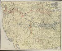
Imperfect: Tear in lower left., Relief shown by hachures., and Shows western states, drainage, cities and towns, and the railroads with emphasis on the main line.
Publisher:
[G.W. & C.B. Colton],
Subject (Name):
Union Pacific Railway Company and Union Pacific Railway Company--Maps
Subject (Topic):
Railroads--West (U.S.)--Maps
Found in:
Beinecke Rare Book and Manuscript Library > Map showing the Union Pacific Railway and connecting railroads / prepared by G.W. & C.B. Colton & Co.
Creator:
Published / Created:
1883
Call Number:
80gme 1883B
Container / Volume:
BRBL_00539
Image Count:
1
Resource Type:
Maps, Atlases & Globes
Description:
Relief shown by hachures. and Shows western states, drainage, cities and towns, and the railroads with emphasis on the main line.
Publisher:
[G.W. & C.B. Colton],
Subject (Name):
Union Pacific Railway Company and Union Pacific Railway Company--Maps
Subject (Topic):
Railroads--West (U.S.)--Maps
Found in:
Beinecke Rare Book and Manuscript Library > Map showing the Union Pacific Railway and connecting railroads / prepared by G.W. & C.B. Colton & Co.
Creator:
Published / Created:
1885
Call Number:
80gme 1885
Container / Volume:
BRBL_00539
Image Count:
1
Resource Type:
Maps, Atlases & Globes
Description:
Relief shown by hachures. and Shows western states, drainage, cities and towns, and the railroads with emphasis on the main line.
Publisher:
[G.W. & C.B. Colton],
Subject (Name):
Union Pacific Railway Company and Union Pacific Railway Company--Maps
Subject (Topic):
Railroads--West (U.S.)--Maps
Found in:
Beinecke Rare Book and Manuscript Library > Map showing the Union Pacific Railway and connecting railroads / prepared by G.W. & C.B. Colton & Co.
Creator:
Published / Created:
[ca. 1874].
Call Number:
75gme 1874
Container / Volume:
BRBL_00412
Image Count:
1
Resource Type:
Maps, Atlases & Globes
Description:
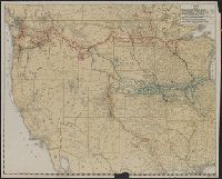
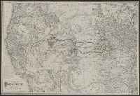
Lists general superintendents and general passenger and ticket agents for Union Pacific Railroad Company and Central Pacific Railroad Company., Relief shown by hachures., and Shows Union Pacific-Central Pacific transcontinental railroad, its land grants, other railroads, proposed railroads, and stage routes.
Publisher:
Rand, McNally & Co.,
Subject (Name):
Central Pacific Railroad Company, Central Pacific Railroad Company--Maps, Union Pacific Railroad Company, and Union Pacific Railroad Company--Maps
Subject (Topic):
Railroad land grants--West (U.S.)--Maps, Railroads--United States--Maps, and Railroads--West (U.S.)--Maps
Found in:
Beinecke Rare Book and Manuscript Library > New map of the American overland route : showing its connections, and land grants of 30,000,000 acres / engraved and published by Rand McNally & Co.
Branch:v1.61.8 ,Deployed:2024-06-20T11:15:02-04:00