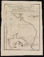
"No. 15" in upper right corner; "VII.D." in lower right corner., From Almindelig histoirie over reiser til lands og bands ... (Kjøbenhavn: Niels Hansen Møller, 1749), a translation of Collection of voyages and travels edited by Awnsham Chruchill and Thomas Osborne., Relief shown pictorially; depths by soundings., and Watermark.
Publisher:
[Niels Hansen Møller],
Subject (Geographic):
--Earlyworksto1800.
Subject (Name):
Bellin, Jacques Nicolas, 1703-1772, Churchill, Awnsham, -1728. Collection of voyages and travels. Danish., Møller, Niels Hansen, and Osborne, Thomas, -1767. Collection of voyages and travels. Danish.
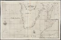
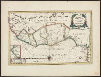
Covers coastal western and central Africa from Sierra Leone to Gabon., From Ogilby's Africa, being an accurate description of the regions, Includes ill. and decorative cartouche., Relief shown pictorially., and Verso: stamped "Map Collection Yale Univ. Library".
Publisher:
Printed by T. Johnson for the author,
Subject (Geographic):
Africa, West--Maps--Earlyworksto1800
Subject (Name):
Ogilby, John, 1600-1676. Africa, being an accurate description of the regions of Egypt, Barbary, Lybia and Billedulgerid
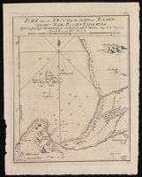
Appears in Dudley's Dell'arcano del mare., Has watermarks., Includes ill. and inset of the eastern coast of Africa from the Gulf of Aden to Zanzibar., and Library copy annotated in brown ink: Fig. 18.
Publisher:
R. Dudley,
Subject (Geographic):
Africa, Southern--Maps--Earlyworksto
Subject (Name):
Dudley, Robert, Sir, 1574-1649. Dell'arcano del mare and Lucini, Antonio Francesco, b. 1605
Plan of Table Bay at Cape Town and the Cape of Good Hope in present-day South Africa.
Description:
"No. 4" in upper right corner; "VII.D." in lower right corner., From Almindelig histoirie over reiser til lands og bands ... (Kjøbenhavn: Niels Hansen Møller, 1749), a translation of Collection of voyages and travels edited by Awnsham Chruchill and Thomas Osborne., and Relief shown pictorially; depths shown by soundings.
Publisher:
[Niels Hansen Møller],
Subject (Geographic):
Table Bay (South Africa)--Maps--Early
Subject (Name):
Bellin, Jacques Nicolas, 1703-1772, Churchill, Awnsham, -1728. Collection of voyages and travels. Danish., Møller, Niels Hansen, and Osborne, Thomas, -1767. Collection of voyages and travels. Danish.
"For Mr. Postlethwayt's Universal dictionary of trade & commerce." and Includes ill., text, and inset of "A separate map of the Gold Coast upon a larger scale."
Publisher:
Printed for H. Woodfall [etc.],
Subject (Geographic):
Africa, West--Maps--Earlyworksto1800
Subject (Name):
Postlethwayt, Malachy, 1707?-1767. Universal dictionary of trade and commerce
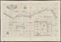
"Di Affrica carta VII.", Covers coastal West Africa from Liberia to Cameroon, From the author's Dell'arcano del mare. 1646-1647., Has watermarks., Includes inset of the Gulf of Guinea., Prime meridian: Pico., and Relief shown pictorially. Depths shown by soundings.
Publisher:
F. Onofri,
Subject (Geographic):
Africa, West--Maps--Earlyworksto1800
Subject (Name):
Dudley, Robert, Sir, 1574-1649. Dell'arcano del mare. 1646-1647 and Lucini, Antonio Francesco, b. 1605
Annotated in black ink in top left margin: 23., Has watermark., Includes inset of coastal Senegal and ornamental cartouche., Relief shown pictorially., and Verso: stamped "Map Collection Yale Univ. Library".
Publisher:
Chez l'auteur sur le Quay de l'horloge, au coin de la rüe de Harlay,
Affbeeldinghe der custen des landts genaempt terra do Natal, item van alle de custen van Coffala, Mozambique, Melinde and Typus orarum maritimarum Guineae, Manicongo, & Angôlae ultra promontorium Bonae Spei.
Description:
Appears in the author's Itinerario, voyage ofte schipvaert van Jan Huygen van Linschoten naer Oost ofte Portugaels Indien., Companion map to Typus orarum maritimarum Guineae, Manicongo, & Angôlae ultra promontorium Bonae Spei ..., and Includes decorative carto
Publisher:
Cornelis Claesz?,
Subject (Geographic):
Africa, Eastern--Maps--Earlyworksto
Subject (Name):
Claesz, Cornelis, approximately 1546-1609, Langren, Arnold Florent van, 1580-1644, and Linschoten, Jan Huygen van, 1563-1611. Itinerario, voyage ofte schipvaert van Jan Huygen van Linschoten naer Oost ofte Portugaels Indien
Affbeeldinghe der custen des landts genaempt terra do Natal, item van alle de custen van Coffala, Mozambique, Melinde and Typus orarum maritimarum Guineae, Manicongo, & Angôlae ultra promontorium Bonae Spei.
Description:
Appears in the author's Itinerario, voyage ofte schipvaert van Jan Huyge, Companion map to Typus orarum maritimarum Guineae, Manicongo, & Angôlae ultra promontorium Bonae Spei ..., Has watermark., and Includes decorative cartouche and compass rose and col. ill.
Publisher:
Cornelis Claesz?,
Subject (Geographic):
Africa, Eastern--Maps--Earlyworksto
Subject (Name):
Claesz, Cornelis, approximately 1546-1609, Langren, Arnold Florent van, 1580-1644, and Linschoten, Jan Huygen van, 1563-1611. Itinerario, voyage ofte schipvaert van Jan Huygen van Linschoten naer Oost ofte Portugaels Indien
"This map is copied from an original drawn by Monsr. D'Anv, Also appeared in Kitchin's General atlas describing the whole universe. London : Printed for Robert Sayer, [1780]., Prime meridians: Ferro and London., and Relief shown pictorially; depths by soundings.
Publisher:
Printed for Robert Sayer,
Subject (Geographic):
Africa, West--Maps--Earlyworksto1800
Subject (Name):
Abbot, Charles,--Baron Colchester,--1757-1829--Bookplate, Anville, Jean Baptiste Bourguignon d', 1697-1782, Kitchin, Thomas, d. 1784. General atlas describing the whole universe, and Robert Laurie and James Whittle