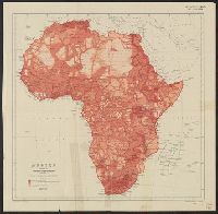
Issued with the Geographical Journal, 1911., Relief shown by spot heights., and Shows areas mapped from surveys, traverses, native reports or entirely unknown.
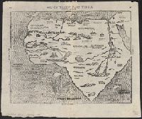
Appears in Bünting's Itinerarium Sacrae Scripturae., In top margin: 20 -- 21., Includes ill., Latin, German., Relief shown pictorially., Sheet measures 32 x 39 cm., and Text on verso.
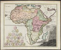
"Engrav'd for Jackson's edition of Payne's new System of universal geography.", Has watermarks., Library copy attached to Route of Mr. Mungo Park., Prime meridian: London., and Relief shown pictorially.
Publisher:
Jackson,
Subject (Geographic):
Africa--Maps--Early works to 1800
Subject (Name):
Ferguson, engraver, Jackson, Zachariah, and Payne, John, fl. 1800. Universal geography formed into a new and entire system
German title and text, Latin place names., Includes text and ill., Relief shown pictorially., Sheet measures 34 x 42 cm., and Text in ornamental frame on verso: Des gantzen Landts Africe, ein gemeine beschreibung. xxv.
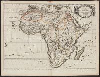
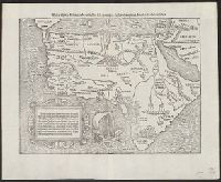
"Cum priuilegio.", Hand col. Sheet measures 47 x 57 cm., Includes text and ornamental cartouche., Latin, French., Pg. nos. on verso: 61, 64., Relief shown pictorially., Running title on verso: L'Afrique., and Signature on verso: Q.
Includes chart showing political divisions by region., On verso: 37., Prime meridians: Greenwich and Ferro., Relief shown pictorially., and Watermark: Whatman 1825.
Publisher:
Published ... by Robert Wilkinson, no. 125 Fenchurch Street : and Republished with additions and corrections by William Darton, 58 Holborn Hill,