Search
You Searched For
Search Results
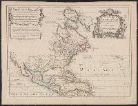
- Creator:
- L'Isle, Guillaume de, 1675-1726
- Published / Created:
- 1700 [i.e. 1708]
- Call Number:
- 71 1708A
- Container / Volume:
- BRBL_00361
- Image Count:
- 1
- Resource Type:
- Maps, Atlases & Globes
- Subject (Geographic):
- North America--Maps--Early works to
- Found in:
- Beinecke Rare Book and Manuscript Library > L'Amérique Septentrionale : dressée sur les observations de Mrs. de l'Académie Royale des Sciences & quelques autres, & sur les mémoires les plus recens / par G. De L'Isle, géographe ; N. Guerard, inv. et fec.
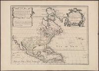
- Creator:
- L'Isle, Guillaume de, 1675-1726
- Published / Created:
- 1700 [i.e. 1708]
- Call Number:
- 71 1708
- Container / Volume:
- BRBL_00361
- Image Count:
- 1
- Resource Type:
- Maps, Atlases & Globes
- Subject (Geographic):
- North America--Maps--Early works to
- Found in:
- Beinecke Rare Book and Manuscript Library > L'Amérique Septentrionale : dressée sur les observations de Mrs. de l'Académie Royale des Sciences & quelques autres, & sur les mémoires les plus recens / par G. De L'Isle, géographe ; N. Guerard, inv. et fec.
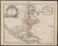
- Creator:
- L'Isle, Guillaume de, 1675-1726
- Published / Created:
- [between 1721 and 1733?]
- Call Number:
- 71 1733B
- Container / Volume:
- BRBL_00362
- Image Count:
- 1
- Resource Type:
- Maps, Atlases & Globes
- Subject (Geographic):
- North America--Maps--Early works to
- Found in:
- Beinecke Rare Book and Manuscript Library > L'Amérique Septentrionale : dressée sur les observations de Mrs. de l'Académie Royale des Sciences & quelques autres, & sur les mémoires les plus recens / par G. de L'Isle.
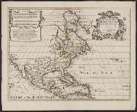
- Creator:
- L'Isle, Guillaume de, 1675-1726
- Published / Created:
- [1760?]
- Call Number:
- 71 1760
- Container / Volume:
- BRBL_00364
- Image Count:
- 1
- Resource Type:
- Maps, Atlases & Globes
- Subject (Geographic):
- North America--Maps--Early works to
- Found in:
- Beinecke Rare Book and Manuscript Library > L'Amérique Septentrionale : dressée sur les observations de mrs. de l'Académie royale des sciences & quelques autres, & sur les mémoires les plus recens / par G. de l'Isle, géographe.
- Creator:
- Nolin, Jean Baptiste, 1648-1708
- Published / Created:
- 1704
- Call Number:
- 71 1704
- Container / Volume:
- BRBL_00361
- Image Count:
- 1
- Resource Type:
- Maps, Atlases & Globes
- Subject (Geographic):
- North America--Maps--Early works to
- Found in:
- Beinecke Rare Book and Manuscript Library > L'Amérique Septentrionale, ou la partie septentrionale des Indes Occidentales, où se trouve le Canada ou Nouvelle France, la Floride, la Virginie, les Isles Antilles, le Nouveau Mexique et la Nouvele. Espagne / dressée sur les mémoires les plus nouvea
- Creator:
- L'Isle, Guillaume de, 1675-1726
- Published / Created:
- [1742?]
- Call Number:
- 71 1700L
- Container / Volume:
- BRBL_00687
- Image Count:
- 1
- Resource Type:
- Maps, Atlases & Globes
- Subject (Geographic):
- North America--Maps--Early works to
- Found in:
- Beinecke Rare Book and Manuscript Library > L'Amérique septentrionale : dressée sur les observations de Mrs. de l'Academie Royale des Sciences & quelques autres, & sur les memoires les plus recens / par G. de l'Isle, geographe.
- Creator:
- Brion de la Tour, Louis
- Published / Created:
- 1783
- Call Number:
- 71 1783A
- Container / Volume:
- BRBL_00366
- Image Count:
- 1
- Resource Type:
- Maps, Atlases & Globes
- Subject (Geographic):
- North America--Maps--Early works to
- Found in:
- Beinecke Rare Book and Manuscript Library > L'Amérique septentrionale : ou se remarquent les Etats Unis / par M. Brion de la Tour, ingénieur-géographe du roi.
- Creator:
- Sanson, Nicolas, 1600-1667
- Published / Created:
- 1656
- Call Number:
- 71 1656
- Container / Volume:
- BRBL_00360
- Image Count:
- 1
- Resource Type:
- Maps, Atlases & Globes
- Subject (Geographic):
- North America--Maps--Early works to
- Found in:
- Beinecke Rare Book and Manuscript Library > Le Nouveau Mexique et la Floride : tirées de diverses cartes, et relations / par N. Sanson ; Somer sculp.
- Creator:
- Sanson, Nicolas, 1600-1667
- Published / Created:
- 1679
- Call Number:
- 841 1679
- Container / Volume:
- BRBL_00691
- Image Count:
- 1
- Resource Type:
- Maps, Atlases & Globes
- Subject (Geographic):
- North America--Maps--Early works to
- Found in:
- Beinecke Rare Book and Manuscript Library > Le nouveau Mexique et la Floride : tirées de diverses cartes et relations / par N. Sanson d'Abbeville ... ; Somer sculp.
- Creator:
- Wytfliet, Corneille
- Published / Created:
- 1597]
- Call Number:
- 71 1597C
- Container / Volume:
- BRBL_00725
- Image Count:
- 1
- Resource Type:
- Maps, Atlases & Globes
- Subject (Geographic):
- North America--Maps--Early works to
- Found in:
- Beinecke Rare Book and Manuscript Library > Limes occidentis, Quiuira et Anian, 1597.
- Published / Created:
- [1736?]
- Call Number:
- 755 1736
- Container / Volume:
- BRBL_00728
- Image Count:
- 1
- Resource Type:
- Maps, Atlases & Globes
- Subject (Geographic):
- North America--Maps--Early works to
- Found in:
- Beinecke Rare Book and Manuscript Library > New England, New York, New Jersey and Pensylvania.
- Creator:
- Gibson, J. (John)
- Published / Created:
- 1753?]
- Call Number:
- 71 1753A
- Container / Volume:
- BRBL_00362
- Image Count:
- 1
- Resource Type:
- Maps, Atlases & Globes
- Subject (Geographic):
- North America--Maps--Early works to
- Found in:
- Beinecke Rare Book and Manuscript Library > North America / J. Gibson sculpt.
- Creator:
- Kitchin, Thomas, d. 1784
- Published / Created:
- 178-?]
- Call Number:
- 71 1784B
- Container / Volume:
- BRBL_00366
- Image Count:
- 1
- Resource Type:
- Maps, Atlases & Globes
- Subject (Geographic):
- North America--Maps--Early works to
- Found in:
- Beinecke Rare Book and Manuscript Library > North America / drawn from the latest & best authorities by Thos. Kitchin.
- Creator:
- Senex, John, d. 1740
- Published / Created:
- 1710]
- Call Number:
- 71 1714
- Container / Volume:
- BRBL_00687
- Image Count:
- 1
- Resource Type:
- Maps, Atlases & Globes
- Subject (Geographic):
- North America--Maps--Early works to
- Found in:
- Beinecke Rare Book and Manuscript Library > North America : corrected from the observations communicated to the Royal Society at London and the Royal Academy at Paris / by Iohn Senex and John Maxwell, geographers.
- Creator:
- Senex, John, d. 1740
- Published / Created:
- 1710]
- Call Number:
- 71 1710A
- Container / Volume:
- BRBL_00361
- Image Count:
- 1
- Resource Type:
- Maps, Atlases & Globes
- Subject (Geographic):
- North America--Maps--Early works to
- Found in:
- Beinecke Rare Book and Manuscript Library > North America : corrected from the observations communicated to the Royal Society at London and the Royal Academy at Paris / by Iohn Senex and John Maxwell, geographers.
- Creator:
- Senex, John, d. 1740
- Published / Created:
- 1710]
- Call Number:
- 71 1710B
- Container / Volume:
- BRBL_00687
- Image Count:
- 1
- Resource Type:
- Maps, Atlases & Globes
- Subject (Geographic):
- North America--Maps--Early works to
- Found in:
- Beinecke Rare Book and Manuscript Library > North America : corrected from the observations communicated to the Royal Society at London and the Royal Academy at Paris / by Iohn Senex, Cha. Price & John Maxwell, geographers.
- Creator:
- Senex, John, d. 1740
- Published / Created:
- 1710]
- Call Number:
- 71 1710
- Container / Volume:
- BRBL_00687
- Image Count:
- 1
- Resource Type:
- Maps, Atlases & Globes
- Subject (Geographic):
- North America--Maps--Early works to
- Found in:
- Beinecke Rare Book and Manuscript Library > North America : corrected from the observations communicated to the Royal Society at London and the Royal Academy at Paris / by Iohn Senex, F.R.S.
- Creator:
- Senex, John, -1740
- Published / Created:
- [between 1750 and 1769?]
- Call Number:
- 71 1755B
- Container / Volume:
- BRBL_00363
- Image Count:
- 1
- Resource Type:
- Maps, Atlases & Globes
- Subject (Geographic):
- North America--Maps--Early works to
- Found in:
- Beinecke Rare Book and Manuscript Library > North America : corrected from the observations communicated to the Royal Society at London and the Royal Academy at Paris / by John Senex F.R.S., 1710.
- Creator:
- Bolton, Solomon, d. ca. 1768
- Published / Created:
- 1766]
- Call Number:
- 71 1766B
- Container / Volume:
- BRBL_00364
- Image Count:
- 4
- Resource Type:
- Maps, Atlases & Globes
- Subject (Geographic):
- North America--Maps--Early works to
- Found in:
- Beinecke Rare Book and Manuscript Library > North America : performed under the patronage of Louis Duke of Orleans, First Prince of the Blood / by the Sieur d'Anville, greatly improved by Mr. Bolton ; engraved by R.W. Seale ; Gravelot, delin. ; Walker, sculp.
- Creator:
- Kitchin, Thomas, d. 1784
- Published / Created:
- Sepr. 29th 1787.
- Call Number:
- 71 1787D
- Container / Volume:
- BRBL_00366
- Image Count:
- 1
- Resource Type:
- Maps, Atlases & Globes
- Alternative Title:
- Map of North America (1787)
- Description:
- . with label titled "Map of North America
- Subject (Geographic):
- North America--Maps--Early works to
- Found in:
- Beinecke Rare Book and Manuscript Library > North America drawn from the latest and best authorities / T. Kitchin, del. ; engrav'd by G. Terry.
- Creator:
- Conder, Thomas, 1746 or 1747-1831
- Published / Created:
- 1782?]
- Call Number:
- 71 1782A
- Container / Volume:
- BRBL_00366
- Image Count:
- 1
- Resource Type:
- Maps, Atlases & Globes
- Subject (Geographic):
- North America--Maps--Early works to
- Found in:
- Beinecke Rare Book and Manuscript Library > North America, agreeable to the most approved maps and charts / by Thos. Conder.
- Creator:
- Seutter, Matthaeus, 1678-1756
- Published / Created:
- [1745]
- Call Number:
- BrSides 2019 65
- Image Count:
- 1
- Resource Type:
- Maps, Atlases & Globes
- Subject (Geographic):
- North America--Maps--Early works to
- Found in:
- Beinecke Rare Book and Manuscript Library > Nov[us] orbis sive America septentrionalis, divisa per sua regna provinc. et insul : cura et opera / Matth. Seutter S.C.M. Geogr. Aug. V. ; A.C. Seutter delin., Tob. Conr. Lotter sculpsit.
- Creator:
- Quad, Matthias, 1557-1613
- Published / Created:
- between 1600 and 1608]
- Call Number:
- 71 1600
- Container / Volume:
- BRBL_00687
- Image Count:
- 2
- Resource Type:
- Maps, Atlases & Globes
- Subject (Geographic):
- North America--Maps--Early works to
- Found in:
- Beinecke Rare Book and Manuscript Library > Novi orbis pars borealis, America scilicet complectens Floridam, Baccalaon, Canadam, terram Corterialem, Virginiam, Norombecam, pluresque alias provincias.
- Published / Created:
- 177-?]
- Call Number:
- 71 1769
- Container / Volume:
- BRBL_00364
- Image Count:
- 1
- Resource Type:
- Maps, Atlases & Globes
- Subject (Geographic):
- North America--Maps--Early works to
- Found in:
- Beinecke Rare Book and Manuscript Library > Partie de la carte du Capitaine Cluny auteur d'un ouvrage anglois intitulé American traveller publié à Londre en 1769.
- Creator:
- Rhode, Johann Christoph, cartographer
- Call Number:
- 755 1755AA
- Container / Volume:
- BRBL_00427
- Image Count:
- 1
- Resource Type:
- Maps, Atlases & Globes
- Subject (Geographic):
- North America--Maps--Early works to
- Found in:
- Beinecke Rare Book and Manuscript Library > Theatrum belli in America Septentrionali / II. foliis comprehensum jussu Acad. Reg. Scient. et Eleg. Litt. exhibet I. C. Rhode Ac: Geogr. ; Berger, sculpsit berol.
- Published / Created:
- 1772?]
- Call Number:
- 755 1772
- Container / Volume:
- BRBL_00728
- Image Count:
- 2
- Resource Type:
- Maps, Atlases & Globes
- Subject (Geographic):
- North America--Maps--Early works to
- Found in:
- Beinecke Rare Book and Manuscript Library > Theatrum belli in America Septentrionali, II foliis comprehensum ... exhibet I.C. Rhode ...
- Creator:
- Terasson, H., fl. 1715
- Published / Created:
- [1720?]
- Call Number:
- 71 1720A
- Container / Volume:
- BRBL_00361
- Image Count:
- 1
- Resource Type:
- Maps, Atlases & Globes
- Alternative Title:
- This map of North America (corrected
- Description:
- "Note--same map as 'North America. By
- Subject (Geographic):
- North America--Maps--Early works to
- Found in:
- Beinecke Rare Book and Manuscript Library > To his sacred & most exellent majesty George, by the grace of God, King of Great Britain, France, and Ireland &c., this map of North America (corrected from the latest discoveries and observations) is most humbly dedicated / by his Majesty's most obedient
- Creator:
- Moll, Herman, d. 1732
- Published / Created:
- [1720]
- Call Number:
- 71 1720D
- Container / Volume:
- BRBL_00361
- Image Count:
- 1
- Resource Type:
- Maps, Atlases & Globes
- Subject (Geographic):
- North America--Maps--Early works to
- Found in:
- Beinecke Rare Book and Manuscript Library > To the right honourable John Lord Sommers, Baron of Evesham in ye county of Worcester, president of Her Majesty's most honourable Privy Council &c., this map of North America, according to ye newest and most exact observations is most humbly dedicated by
- Published / Created:
- ca. 1790?]
- Call Number:
- 71 1790C
- Container / Volume:
- BRBL_00367
- Image Count:
- 1
- Resource Type:
- Maps, Atlases & Globes
- Subject (Geographic):
- North America--Maps--Early works to
- Found in:
- Beinecke Rare Book and Manuscript Library > [Amérique Septentrionale].
- Published / Created:
- ca. 1790?]
- Call Number:
- 71 1790
- Container / Volume:
- BRBL_00367
- Image Count:
- 1
- Resource Type:
- Maps, Atlases & Globes
- Subject (Geographic):
- North America--Maps--Early works to
- Found in:
- Beinecke Rare Book and Manuscript Library > [Amérique Septentrionale].
- Creator:
- Coronelli, Vincenzo, 1650-1718
- Published / Created:
- 1693-1707]
- Call Number:
- 71 1693 31
- Container / Volume:
- BRBL_00735
- Image Count:
- 1
- Resource Type:
- Maps, Atlases & Globes
- Subject (Geographic):
- North America--Maps--Early works to
- Found in:
- Beinecke Rare Book and Manuscript Library > [Globe gore covering central North America]
- Creator:
- Pownall, Thomas, 1722-1805
- Published / Created:
- between 1783 and 1799?]
- Call Number:
- 71 1785C
- Container / Volume:
- BRBL_00366
- Image Count:
- 2
- Resource Type:
- Maps, Atlases & Globes
- Alternative Title:
- Map of North America and the West
- Description:
- An issue of the Pownall map of North
- Subject (Geographic):
- North America--Maps--Early works to
- Found in:
- Beinecke Rare Book and Manuscript Library > [Pownall's map of North America and the West Indies].
- Creator:
- Moll, Herman, -1732
- Published / Created:
- 1715
- Call Number:
- 755 1715C
- Container / Volume:
- BRBL_00425
- Image Count:
- 1
- Resource Type:
- Maps, Atlases & Globes
- Description:
- America --A map of the improved part of
- Subject (Geographic):
- North America--Maps--Early works to
- Found in:
- Beinecke Rare Book and Manuscript Library > A new and exact map of the dominions of the King of Great Britain on ye continent of North America [cartographic material] : containing Newfoundland, New Scotland, New England, New York, New Jersey, Pensilvania, Maryland, Virginia and Carolina according t
- Published / Created:
- 1889
- Call Number:
- 827 1889
- Container / Volume:
- BRBL_00577
- Image Count:
- 1
- Resource Type:
- Maps, Atlases & Globes
- Subject (Topic):
- Indians of North America--Oklahoma
- Found in:
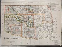
- Beinecke Rare Book and Manuscript Library > Indian territory / compiled under the direction of the Hon. John H. Oberly, Commissioner of Indian Affairs, by C.A. Maxwell ; John Olberg, draftsman.
- Creator:
- Emory, William H. (William Hemsley), 1811-1887
- Published / Created:
- 1844
- Call Number:
- 796 1844A
- Container / Volume:
- BRBL_00524
- Image Count:
- 1
- Resource Type:
- Maps, Atlases & Globes
- Subject (Topic):
- Indians of North America--Oklahoma
- Found in:
- Beinecke Rare Book and Manuscript Library > Map of Texas and the country adjacent / compiled in the Bureau of the Corps of Topographical Engeneers [sic], from the best authorities, for the State Department, under the direction of Col. J.J. Abert, Chief of the Corps, by W.H. Emory, 1st Lieut. T.E.
- Creator:
- Rand McNally and Company
- Published / Created:
- c1889.
- Call Number:
- 75gme 1889
- Container / Volume:
- BRBL_00414
- Image Count:
- 2
- Resource Type:
- Maps, Atlases & Globes
- Subject (Topic):
- Railroads--North America--Maps
- Found in:
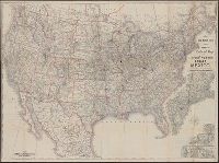
- Beinecke Rare Book and Manuscript Library > Rand McNally & Co.'s new official railroad map of the United States, Canada, and Mexico.
- Creator:
- Rand McNally and Company
- Published / Created:
- 1891, c1889.
- Call Number:
- 75gme 1891
- Container / Volume:
- BRBL_00414
- Image Count:
- 2
- Resource Type:
- Maps, Atlases & Globes
- Subject (Topic):
- Railroads--North America--Maps
- Found in:
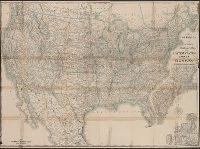
- Beinecke Rare Book and Manuscript Library > Rand McNally & Co.'s new official railroad map of the United States, Canada, and Mexico.
- Creator:
- Jode, Cornelis de, 1568-1600
- Published / Created:
- 19--?]
- Call Number:
- 71 1593
- Container / Volume:
- BRBL_00359
- Image Count:
- 1
- Resource Type:
- Maps, Atlases & Globes
- Subject (Geographic):
- North America--Maps--Early works to
- Found in:
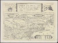
- Beinecke Rare Book and Manuscript Library > Americae pars borealis, Florida, Baccalaos, Canada, Corterealis / A Cornelio de Iudaeis in luce edita.
- Creator:
- Poirson, Jean Baptiste, 1760-1831
- Published / Created:
- 1811
- Call Number:
- 88 1811
- Container / Volume:
- BRBL_00644
- Image Count:
- 1
- Resource Type:
- Maps, Atlases & Globes
- Subject (Geographic):
- North America--Maps
- Found in:
- Beinecke Rare Book and Manuscript Library > Carte du Mexique et des pays limitrophes situés au nord et à l'est : dressée d'après la grande carte de la Nouvelle Espagne de Mr. A. de Humboldt et d'autres matériaux / par J.B. Poirson ; gravé par Barriere ;l'́ecriture par L. Aubert.
- Creator:
- Moll, Herman, d. 1732
- Call Number:
- 85 1745A
- Container / Volume:
- BRBL_00636
- Image Count:
- 1
- Resource Type:
- Maps, Atlases & Globes
- Subject (Topic):
- Coasts--North America--Maps--Early
- Found in:
- Beinecke Rare Book and Manuscript Library > A chart of ye West-Indies or the islands of America in the North Sea &c., being ye present seat of war / by Herman Moll, geographer.
- Creator:
- Visscher, Nicolaes, 1649-1702
- Published / Created:
- [ca. 1720]
- Call Number:
- 85 1710
- Container / Volume:
- BRBL_00692
- Image Count:
- 1
- Resource Type:
- Maps, Atlases & Globes
- Subject (Topic):
- Coasts--North America--Maps--Early
- Found in:
- Beinecke Rare Book and Manuscript Library > Insulae Americanae in Oceano Septentrionali ac regiones adiacentes : a C. de May usque ad Lineam Aequinoctialem / per Nicolaum Visscher.
- Creator:
- Visscher, Nicolaes, 1649-1702
- Published / Created:
- ca. 1682]
- Call Number:
- 85 1650A
- Container / Volume:
- BRBL_00692
- Image Count:
- 1
- Resource Type:
- Maps, Atlases & Globes
- Subject (Topic):
- Coasts--North America--Maps--Early
- Found in:
- Beinecke Rare Book and Manuscript Library > Insulae Americanae in Oceano Septentrionali ac regiones adiacentes : a C. de May usque ad Lineam Aequinoctialem / per Nicolaum Visscher.
- Creator:
- Jansson, Jan, 1588-1664
- Published / Created:
- [1660?]
- Call Number:
- 85 1660
- Container / Volume:
- BRBL_00636
- Image Count:
- 1
- Resource Type:
- Maps, Atlases & Globes
- Subject (Topic):
- Coasts--North America--Maps--Early
- Found in:
- Beinecke Rare Book and Manuscript Library > Insulae Americanae in Oceano Septentrionali cum terris adiacentibus [cartographic material].
- Creator:
- Jansson, Jan, 1588-1664
- Published / Created:
- [1645]
- Call Number:
- 85 1652
- Container / Volume:
- BRBL_00636
- Image Count:
- 2
- Resource Type:
- Maps, Atlases & Globes
- Subject (Topic):
- Coasts--North America--Maps--Early
- Found in:
- Beinecke Rare Book and Manuscript Library > Insulae Americanae in Oceano Septentrionali cum terris adiacentibus [cartographic material].
- Creator:
- Blaeu, Willem Janszoon, 1571-1638
- Published / Created:
- 1667?]
- Call Number:
- 85 1667
- Container / Volume:
- BRBL_00636
- Image Count:
- 1
- Resource Type:
- Maps, Atlases & Globes
- Subject (Topic):
- Coasts--North America--Maps--Early
- Found in:
- Beinecke Rare Book and Manuscript Library > Insulae Americanae in Oceano Septentrionali cum terris adiacentibus.
- Creator:
- Jansson, Jan, 1588-1664
- Published / Created:
- [1644]
- Call Number:
- 85 1652A
- Container / Volume:
- BRBL_00692
- Image Count:
- 1
- Resource Type:
- Maps, Atlases & Globes
- Subject (Topic):
- Coasts--North America--Maps--Early
- Found in:
- Beinecke Rare Book and Manuscript Library > Insulae Americanae in Oceano Septentrionali cum terris adiacentibus.
- Creator:
- Blaeu, Willem Janszoon, 1571-1638
- Published / Created:
- after 1635?]
- Call Number:
- 85 1673
- Container / Volume:
- BRBL_00692
- Image Count:
- 1
- Resource Type:
- Maps, Atlases & Globes
- Subject (Topic):
- Coasts--North America--Maps--Early
- Found in:
- Beinecke Rare Book and Manuscript Library > Insulae Americanae in Oceano Septentrionali cum terris adiacentibus.