

- None3
You Searched For
1 - 9 of 9
Search Results
2.
- Creator:
- James, Edwin, 1797-1861, compiler
- Published / Created:
- 1822-1823.
- Call Number:
- Zc20 +822ja
- Image Count:
- 41
- Resource Type:
- text and still image
- Alternative Title:
- Major Long's Expedition to the Rocky Mountains and Expedition to the Rocky Mountains
- Description:
- Spine title, on publisher's printed labels: Major Long's Expedition to the Rocky Mountains., Engravings by Young & Delleker, Cephas Grien Childs, Alexander Lawson, Francis Kearney, and William Hay; after Stephen H. Long, Samuel Seymour and Titian Ramsay Peale., Some maps on double leaves., Text and atlas in slipcase., BEIN: Bookplate of Joseph Y. Jeanes., GEO: Atlas wanting, no slipcase., and BAC: British Art Center copy complete with atlas. Bound in publisher's original tan boards. Inscribed: Maine Charity School from Mrs. Lord.
- Publisher:
- H.C. Carey and I. Lea, Chesnut St.
- Subject (Geographic):
- West (U.S.), Ohio River, Missouri River, and United States
- Subject (Topic):
- Discovery and exploration, Indians of North America, Languages, Geology, Discoveries in geography, and Glossaries, vocabularies, etc
- Found in:
- Beinecke Rare Book and Manuscript Library > Account of an expedition from Pittsburgh to the Rocky Mountains : performed in the years 1819 and '20, by order of the Hon. J.C. Calhoun, Sec'y of War ; under the command of Major Stephen H. Long : from the notes of Major Long, Mr. T. Say, and other gentlemen of the exploring party
3.

- Creator:
- Hughes, J., active 1872, artist
- Published / Created:
- [30 March 1872]
- Call Number:
- Drawings H893 no. 1 Box D128
- Image Count:
- 1
- Resource Type:
- still image
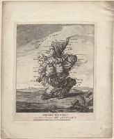
- Abstract:
- A comic map of Great Britain: an old woman is shown in profile, facing to the left, and seated on the back of a dolphin-like monster. At the top her cap is Scotland; her neck is labeled R. Tees (River Tees) and along her back is "Humber" and "The Wash" The mouth of the creature is labeled "Thames". The other points on the map are: Isle of Wight and Bristol Channel, Cardogan Bay, and Anglesea (a bird perched on the woman's out-stretched hand).
- Alternative Title:
- Britannia
- Description:
- Title supplied by artist above design., Added title supplied by cataloger, based on the Gillray print of which this is a copy., Signed and dated by the artist in lower margin., and Drawn after James Gillray's print "Britannia", published 25 June 1791. Cf. No. 8045 in the Catalogue of prints and drawings in the British Museum. Division I, political and personal satires, v. 6.
- Subject (Geographic):
- England
- Found in:
- Lewis Walpole Library > England [art original]
4.

- Creator:
- Dighton, Robert, 1752-1814, printmaker
- Published / Created:
- [1793]
- Call Number:
- 793.00.00.03 Impression 3
- Image Count:
- 1
- Resource Type:
- still image
- Abstract:
- "A grotesque figure, resembling Punch, kneels in profile to the left, with a large thistle in the foreground (right). He bestrides a sack or bundle which rests on the ground, one end forming the 'Mull of Galloway', the other 'St Abbs Head'. The coast-line from the 'Murray Firth' to the 'Firth of Tay' is formed by his hump."--British Museum online catalogue
- Alternative Title:
- Droll caricature map of Scotland
- Description:
- Title from item., Publication date from British Museum catalogue., 1 print : etching with engraving and stipple engraving ; sheet 19.8 x 16.2 cm., Printed on wove paper; hand-colored., and Imperfect; sheet trimmed within plate mark resulting in loss of imprint statement from bottom edge.
- Publisher:
- Printed for Bowles & Carver, No. 69 St Paul's Church Yard
- Subject (Geographic):
- Scotland
- Subject (Topic):
- Scots, Ethnic stereotypes, National emblems, Scottish, and Maps
- Found in:
- Lewis Walpole Library > Geography bewitched!, or, A droll caricature map of Scotland
5.
- Creator:
- Dighton, Robert, 1752-1814, printmaker
- Published / Created:
- [1793]
- Call Number:
- 793.00.00.03 Impression 1
- Image Count:
- 1
- Resource Type:
- still image
- Abstract:
- "A grotesque figure, resembling Punch, kneels in profile to the left, with a large thistle in the foreground (right). He bestrides a sack or bundle which rests on the ground, one end forming the 'Mull of Galloway', the other 'St Abbs Head'. The coast-line from the 'Murray Firth' to the 'Firth of Tay' is formed by his hump."--British Museum online catalogue
- Alternative Title:
- Droll caricature map of Scotland
- Description:
- Title from item., Publication date from British Museum catalogue., and Mounted to 37 x 28 cm.
- Publisher:
- Printed for Bowles & Carver, No. 69 St Paul's Church Yard
- Subject (Geographic):
- Scotland
- Subject (Topic):
- Scots, Ethnic stereotypes, National emblems, Scottish, and Maps
- Found in:
- Lewis Walpole Library > Geography bewitched!, or, A droll caricature map of Scotland
6.

- Creator:
- Barton, Charles Crillon, -1851, artist
- Published / Created:
- [1847]
- Image Count:
- 1
- Resource Type:
- still image
- Abstract:
- Sailing ships in the harbor watch over American troops camped in tents on the island
- Description:
- Title from caption below image., Below main image, and dividing title in half, is a small inset map of the island with title "Boat book draft of the island of Lobos, Gulf of Mexico.", "On stone by H. Dacre.", and "Entered according to act of Congress in the year 1847, by P.S. Duval ..."
- Publisher:
- Published by P.S. Duval, no. 7 Bank Alley
- Subject (Geographic):
- Mexico and Veracruz-Llave (State)
- Subject (Topic):
- Islands, Military camps, Mexican War, 1846-1848, and Campaigns
- Found in:
- Beinecke Rare Book and Manuscript Library > The island of Lobos : rendezvous of the U.S. Army under General Scott, previous to the attack on Vera Cruz, February 9th, 1847
7.

- Creator:
- Ram, Johannes de, 1648-1693, printmaker
- Published / Created:
- [approximately 1690]
- Call Number:
- 724 690R
- Image Count:
- 59
- Resource Type:
- still image
- Abstract:
- Views of Rome (including the Vatican City), London, Amsterdam, and Tangier
- Description:
- All engraved. and Bound in full contemporary calf, spine gilt, red morocco label. For further information, consult library staff.
- Publisher:
- publisher not identified
- Subject (Geographic):
- London (England), Rome (Italy), Amsterdam (Netherlands), and Vatican City
- Found in:
- Lewis Walpole Library > Voornaamste gebouwen vande stadt Romen t'Amsterdam
8.
- Published / Created:
- [between 1777 and 1795]
- Call Number:
- 24 17 791P Copy 9
- Image Count:
- 23
- Resource Type:
- still image and cartographic image
- Abstract:
- A collection of prints, assembled by an unidentified individual, added as extra-illustrations to a copy of the sixth edition of Horace Walpole's The castle of Otranto (Parma : Bodoni, for J. Edwards, 1791). Included are the six plates drawn by "a Lady" (Anne Millicent Clarke) and engraved by Andrew Birrel, published by E. and S. Harding in July 1793 to accompany either this Bodini edition of The castle of Otranto or the small octavo edition (see: Hazen, A.T. A bibliography of Horace Walpole, page 61). Also present are several prints issued with other editions of the work: four plates from the German translation Die Burg von Otranto (Berlin : C.F. Himburg, 1794); one plate published as the frontispiece to Sivrac's Italian translation Il castello di Otranto (Londra : Molini, Polidori, Molini e Co.; Ed I. Edwards, 1795); and one plate likely from a London edition of the 1790s, with the publication line "Published by Wenman & Hodgson, 144 Fleet St." trimmed away. Tipped in at the end flyleaf is an oval design trimmed from the title page to Francis Grose's Supplement to The antiquities of England and Wales (London : S. Hooper, 1777); it depicts a cross in cloister, with two monks standing to the right and a tower in the background, and has verses from Milton's Il penseroso etched below. Also tipped in is a map of the southern tip of Italy entitled "Apuliae quae olim Iapygia, nova corographia", likely a copy of a late-16th century original and With two small manuscript scraps, in Thomas Kirgate's hand, mounted on a leaf tipped in before page xv. The first notes that Mrs. Fenn's 1784 work The female guardian contains "two whole pages in praise of The castle of Otranto as a moral storey", and that Mr. Jephson's play The Count of Narbonne "is taken from The castle of Otranto." The second pertains to the drawing from which the frontispiece plates in this edition were engraved: "South view of the Castle of Otranto, with the Acroceraunian Mountains of Epirus in the distance: taken on the spot March 22d, 1785. Given to Mr. Horace Walpole by Lady Craven, November 1786."
- Description:
- Title devised by cataloger. and Also bound in are five drawings, a stipple portrait of Lady Mary Coke, and an engraved trade card; these are cataloged separately.
- Subject (Name):
- Walpole, Horace, 1717-1797.
- Subject (Topic):
- Castles & palaces, Cloisters, and Monks
- Found in:
- Lewis Walpole Library > [Collection of prints bound in an extra-illustrated copy of The castle of Otranto].
9.
- Published / Created:
- [early 20th century]
- Call Number:
- GEN MSS 1486 (Oversize)
- Container / Volume:
- Box (Oversize)
- Image Count:
- 2
- Resource Type:
- still image
- Abstract:
- A photomechanical print probably created during the early twentieth century as a forgery that reproduces twelve gores for a globe published in 1507 by Martin Waldseemüller based on his wall map, Universalis Cosmographia (1507). and Evidence of the forgery includes the superimposition of the gores over glue already on the paper surface, which suggests use of a sheet removed from a period volume, as well as details that replicate gores from an authentic woodcut print formerly owned by Austrian cartographer Franz Hauslab and acquired by the James Ford Bell Library at the University of Minnesota in 1954
- Description:
- A gore is a roughly triangular or wedge-shaped segment of an object, as found in domes and globes, where a sector of a curved surface, or a curved surface that lies between two close lines of longitude on a globe, and flattened to a plane surface with little distortion., Martin Waldseemüller (1470-1519) was a German cartographer. His wall map Universalis Cosmographia (1507) and printed globes contemporarily derived from it were the first published globular maps of the Western Hemisphere and the first maps on which the name America appears in honor of Italian explorer Amerigo Vespucci (1454-1512)., In Latin., Title devised by cataloger., and Publication place and date of creation supplied by the cataloger.
- Subject (Geographic):
- America
- Subject (Name):
- Hauslab, Franz, 1798-1883., Vespucci, Amerigo, 1451-1512., and Waldseemüller, Martin, 1470-1519
- Subject (Topic):
- Forgeries, Globes, World maps, Discovery and exploration, and Name
- Found in:
- Beinecke Rare Book and Manuscript Library > [Globe gores forgery after Martin Waldseemüller].