Search
You Searched For
Search Results
- Published / Created:
- 1816
- Call Number:
- 56 1816
- Container / Volume:
- BRBL_00295
- Image Count:
- 1
- Resource Type:
- Maps, Atlases & Globes
- Found in:
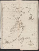
- Beinecke Rare Book and Manuscript Library > A map of the Route of the British Embassy, from the mouth of the Peiho River, to Pekin and from thence to Canton, in the year 1816.
- Creator:
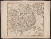
- Cary, John, ca. 1754-1835
- Published / Created:
- Apr. 28, 1811.
- Call Number:
- 56 1811
- Container / Volume:
- BRBL_00685
- Image Count:
- 1
- Resource Type:
- Maps, Atlases & Globes
- Found in:
- Beinecke Rare Book and Manuscript Library > A new map of China, from the latest authorities / by John Cary, engraver.
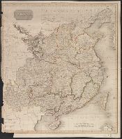
- Creator:
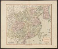
- Cary, John, ca. 1754-1835
- Published / Created:
- Apr. 28, 1811.
- Call Number:
- 56 1811
- Container / Volume:
- BRBL_00295
- Image Count:
- 1
- Resource Type:
- Maps, Atlases & Globes
- Found in:
- Beinecke Rare Book and Manuscript Library > A new map of China, from the latest authorities / by John Cary, engraver.
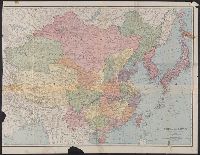
- Creator:
- Rand McNally and Company
- Published / Created:
- c1901.
- Call Number:
- 56 1901A
- Container / Volume:
- BRBL_00296
- Image Count:
- 2
- Resource Type:
- Maps, Atlases & Globes
- Found in:
- Beinecke Rare Book and Manuscript Library > A new map of the Chinese Empire with Japan and Korea. Map of Asia. / by Rand, McNally & Co.
- Creator:
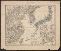
- Petermann, A. (August), 1822-1878
- Published / Created:
- 1877
- Call Number:
- 56 1877
- Container / Volume:
- BRBL_00296
- Image Count:
- 1
- Resource Type:
- Maps, Atlases & Globes
- Found in:
- Beinecke Rare Book and Manuscript Library > China (östl. Theil), Korea und Japan im Massstab 1:7.500.000 / von A. Petermann ; bearbeitet von Ernst Debes ; gestochen v. H. Eberhardt ; Terrain v. C. Jungmann.
- Creator:
- National Geographic Society (U.S.). Cartographic Section
- Published / Created:
- 1945
- Call Number:
- 56 1945
- Container / Volume:
- BRBL_00296
- Image Count:
- 1
- Resource Type:
- Maps, Atlases & Globes
- Found in:
- Beinecke Rare Book and Manuscript Library > China [cartographic material] / compiled and drawn in the Cartographic Section of the National Geographic Society for the National Geographic Magazine ; James M. Darley, chief cartographer.
- Creator:
- United States. Office of Strategic Services. Research and Analysis Branch
- Published / Created:
- 1944
- Call Number:
- 56cb 1944
- Container / Volume:
- BRBL_00297
- Image Count:
- 1
- Resource Type:
- Maps, Atlases & Globes
- Found in:
- Beinecke Rare Book and Manuscript Library > China [cartographic material] / drawn in the Branch of Research and Analysis, OSS.
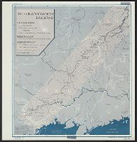
- Creator:
- United States. Office of Strategic Services. Research and Analysis Branch
- Published / Created:
- 1945
- Call Number:
- 56gme H89 1945
- Container / Volume:
- BRBL_00299
- Image Count:
- 1
- Resource Type:
- Maps, Atlases & Globes
- Found in:
- Beinecke Rare Book and Manuscript Library > China [cartographic material] : the Hunan-Kwangsi Railroad / R & A, OSS.
- Creator:
- Rand McNally and Company
- Published / Created:
- [1912]
- Call Number:
- 56 1912A
- Container / Volume:
- BRBL_00296
- Image Count:
- 1
- Resource Type:
- Maps, Atlases & Globes
- Found in:
- Beinecke Rare Book and Manuscript Library > China and Japan [cartographic material].
- Creator:
- United States. Department of State. Interim Research and Intelligence Service. Research and
- Published / Created:
- 1945
- Call Number:
- 56es 1945
- Container / Volume:
- BRBL_00298
- Image Count:
- 1
- Resource Type:
- Maps, Atlases & Globes
- Found in:
- Beinecke Rare Book and Manuscript Library > China food surpluses and deficiencies [cartographic material] / R & A, IRIS.
- Creator:
- United States. Foreign Economic Administration. Far East Enemy Division
- Published / Created:
- 1944
- Call Number:
- 56gm 1944A
- Container / Volume:
- BRBL_00298
- Image Count:
- 2
- Resource Type:
- Maps, Atlases & Globes
- Found in:
- Beinecke Rare Book and Manuscript Library > China transportation [cartographic material] / Foreign Economic Administration, Far East Enemy Division.
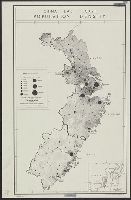
- Creator:
- United States. Office of Strategic Services. Research and Analysis Branch
- Published / Created:
- [1944]
- Call Number:
- 56eb 1944
- Container / Volume:
- BRBL_00298
- Image Count:
- 1
- Resource Type:
- Maps, Atlases & Globes
- Found in:
- Beinecke Rare Book and Manuscript Library > China, east coast [cartographic material] : population density.
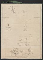
- Published / Created:
- 1859
- Call Number:
- 56cea 1841
- Container / Volume:
- BRBL_00298
- Image Count:
- 1
- Resource Type:
- Maps, Atlases & Globes
- Found in:
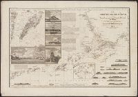
- Beinecke Rare Book and Manuscript Library > China. Bashee and Ballingtang Channels. J. & C. Walker, Sculpt.
- Published / Created:
- 1809
- Call Number:
- 56 1809
- Container / Volume:
- BRBL_00295
- Image Count:
- 1
- Resource Type:
- Maps, Atlases & Globes
- Found in:
- Beinecke Rare Book and Manuscript Library > China. Neele Sculpt.
- Published / Created:
- [1849?]
- Call Number:
- 56 1849
- Container / Volume:
- BRBL_00295
- Image Count:
- 3
- Resource Type:
- Maps, Atlases & Globes
- Found in:
- Beinecke Rare Book and Manuscript Library > Das Chinesische Reich ... Lith u. gedr. im geogr. lith. Institut v. Albr. Platt.
- Published / Created:
- 1834
- Call Number:
- 56cea 1834
- Container / Volume:
- BRBL_00298
- Image Count:
- 1
- Resource Type:
- Maps, Atlases & Globes
- Found in:
- Beinecke Rare Book and Manuscript Library > Die Chinesischen Küste ... Berghaus. Gest. V. H. Herzberg, Berlin.
- Creator:
- United States. Army Map Service
- Published / Created:
- 1944
- Call Number:
- 50 1945N
- Container / Volume:
- BRBL_00273
- Image Count:
- 2
- Resource Type:
- Maps, Atlases & Globes
- Found in:
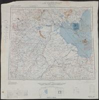
- Beinecke Rare Book and Manuscript Library > Eastern Asia 1:1,000,000 AAF cloth chart. Ryojun NJ-51.
- Creator:
- Geological Survey (U.S.). Topographic Branch
- Published / Created:
- 1921
- Call Number:
- 56fd 1921
- Container / Volume:
- BRBL_00298
- Image Count:
- 1
- Resource Type:
- Maps, Atlases & Globes
- Found in:
- Beinecke Rare Book and Manuscript Library > General map of China and adjacent regions showing treaty ports and railroads / prepared for the Department of State by the Topographic Branch, U.S. Geological Survey, 1921.