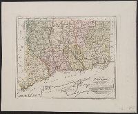
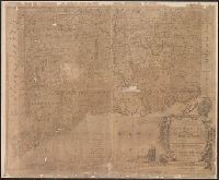
From The Gentleman's magazine and historical chronicle (November, 1776), vol. 46., Prime meridian: London., Relief shown pictorially., Sheet measures 21.2 x 25 cm. Cross Collection no. 199., and Shows Fairfield, New Haven, and New London counties in Connecticut, towns, roads, rivers, and place names in Connecticut, Rhode Island and part of Long Island. Includes copper mine near Simsbury, Conn. Also shows relief.
Publisher:
Gentleman's Magazine,
Subject (Geographic):
Connecticut--Maps--Early works to 1800, Long Island Sound (N.Y. and Conn.)--Maps--Early works to 1800, and Rhode Island--Maps--Early works to 1800
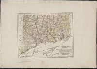
From The Gentleman's magazine and historical chronicle (November, 1776), vol. 46., Prime meridian: London., Relief shown pictorially., Sheet measures 22.2 x 26.3 cm. Cross Collection no. 200., and Shows Fairfield, New Haven, and New London counties in Connecticut, towns, roads, rivers, and place names in Connecticut, Rhode Island and part of Long Island. Includes copper mine near Simsbury, Conn. Also shows relief.
Publisher:
Gentleman's Magazine,
Subject (Geographic):
Connecticut--Maps--Early works to 1800, Long Island Sound (N.Y. and Conn.)--Maps--Early works to 1800, and Rhode Island--Maps--Early works to 1800
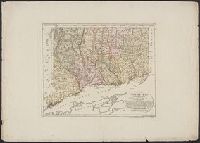
"Zu Ebelings Erdbeschreib, Also shows county boundaries., Bar scales given in "Geographische Meilen 15 auf einen Grad" and "Englische meilen 69 4/25 auf einen Grad.", In upper right margin: No. VI., Place names in German and English., and Relief shown by hachures.
Publisher:
Bey Carl Ernst Bohn,
Subject (Geographic):
Connecticut--Administrative and political divisions--Maps--Early works to 1800 and Connecticut--Maps--Early works to 1800
Subject (Name):
Bohn, Carl Ernst, Ebeling, Christophe Daniel, 1741-1817. Erdbeschreibung und Geschichte von Amerika, and Schmidt, Paulus, engraver
"Zu Ebelings Erdbeschreibung von Amerika.", Also shows county boundaries., Bar scales given in "Geographische Meilen 15 auf einen Grad" and "Englische meilen 69 4/25 auf einen Grad.", In upper right margin: No. VI., Place names in German and English., and Prime me
Publisher:
Bey Carl Ernst Bohn,
Subject (Geographic):
Connecticut--Administrative and political divisions--Maps--Early works to 1800 and Connecticut--Maps--Early works to 1800
Subject (Name):
Bohn, Carl Ernst, Ebeling, Christophe Daniel, 1741-1817. Erdbeschreibung und Geschichte von Amerika, and Schmidt, Paulus, engraver
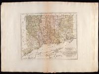
Bohn, Carl Ernst Ebeling, Christophe Daniel, 1741-1817. Erdbeschreibung und Geschichte von Amerika Schmidt, Paulus, engraver Sotzmann, D. F
Published / Created:
1796
Call Number:
1977 Folio 177
Image Count:
2
Resource Type:
Maps, Atlases & Globes
Description:
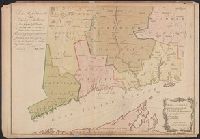
"Zu Ebelings Erdbeschreibung von Amerika.", Also shows county boundaries., Bar scales given in "Geographische Meilen 15 auf einen Grad" and "Englische meilen 69 4/25 auf einen Grad.", In upper right margin: No. VI., Place names in German and English., Prime meridians: Greenwich and Washington., Relief shown by hachures., Sheet measures 53.7 x 72.5 cm. No. 6 of 34 maps bound together., and Watermark.
Publisher:
Bey Carl Ernst Bohn,
Subject (Geographic):
Connecticut--Administrative and political divisions--Maps--Early works to 1800 and Connecticut--Maps--Early works to 1800
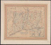
Insets: 1. Hartford &c. 2. New Haven &c., Shows county outlines in color; also townships, roads, canals, railroads, courthouses, churches & taverns., table: Statistical table of pop of counties and towns in 1840. Also pop of Conn. from 1701 to 1840., and Wash. P