
You Searched For
1 - 6 of 6
Search Results

2.

- Creator:
- Berry, William, fl. 1669-1708
- Published / Created:
- 1680.
- Call Number:
- 1973 Folio 10
- Image Count:
- 1
- Alternative Title:
- Europe divided into its principall parts viz. the Brittish [sic] Islands, Scandinavia, Moscovia, France, Germany, Poland, Spain, Italy, Turky [sic] in Europe ... described by Sanson, corrected and amended by William Berry
- Description:
- BEIN 1973 Folio 10: Sheet measures 61 x 96.3 cm. Bookplate of José M. Rodriguez. No. 2 of 63 maps bound together., Relief shown pictorially., Dedicated "To the most serene and most sacred majesty of Charles II ..." by William Berry., Prime meridian: Ferro., and Includes coat of arms and decorative cartouche containing dedication.
- Publisher:
- Sold by William Berry at ye sign of the globe between Charing-Cross and White-Hall
- Subject (Geographic):
- Europe, Russia, and Turkey
- Found in:
- Beinecke Rare Book and Manuscript Library > Europe divided into its principall states, which are subdivided into their principall provinces
3.
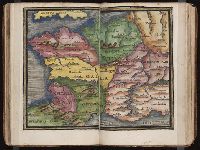
- Published / Created:
- [1542]
- Call Number:
- Taylor 86
- Collection Title:
- Rvdimenta cosmographica
- Image Count:
- 1
- Subject (Geographic):
- Europe and France
- Subject (Topic):
- Cosmography, Early maps, and Geography, Medieval
- Collection Created:
- Impressvm in inclyta Transylvaniae Corona 1542
- Found in:
- Beinecke Rare Book and Manuscript Library > Gallia
4.
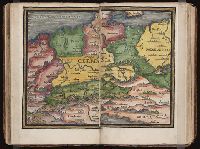
- Published / Created:
- [1542]
- Call Number:
- Taylor 86
- Collection Title:
- Rvdimenta cosmographica
- Image Count:
- 1
- Subject (Geographic):
- Europe and Germany
- Subject (Topic):
- Cosmography, Early maps, and Geography, Medieval
- Collection Created:
- Impressvm in inclyta Transylvaniae Corona 1542
- Found in:
- Beinecke Rare Book and Manuscript Library > Germania
5.
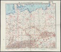
- Creator:
- Germany. Luftwaffe. Generalstab, cartographer, publisher
- Published / Created:
- [1938?]-
- Call Number:
- 319gmp 1942
- Container / Volume:
- 1/2
- Image Count:
- 2
- Resource Type:
- cartographic image
- Description:
- BEIN 319gmp 1942: Imperfect: Blatter 1-2 only. Stamp in upper right corner of Blatt 2: Nur für den Dienstgebraucht., Relief shown by contours, gradient tints, and spot heights; depths shown by contours and soundings., Maps individually titled and numbered, e.g. "Blatt 8 (Vorderasien).", Blätter 1-2, 4-5, 8-9, 10-11, and 12-13 are back to back on one sheet., and Includes sheet index.
- Publisher:
- Generalstab der Luftwaffe
- Subject (Geographic):
- Europe., Africa, North., Eurasia., Europe, Africa, North, Eurasia, and North Africa.
- Subject (Topic):
- Aeronautical charts, World War, 1939-1945, Aerial operations, German, Military operations, Aerial, and German
- Found in:
- Beinecke Rare Book and Manuscript Library > Luft-Navigationskarte in Merkatorprojektion
6.

- Published / Created:
- [between 1800 and 1899?]
- Call Number:
- GEN MSS FILE 601 (Oversize)
- Image Count:
- 2
- Resource Type:
- cartographic image
- Description:
- Title supplied by cataloger., Nineteenth century forgery of a portlan chart., Manuscript note in accompanying case: A manuscript portolan on vellum probably executed by a Spanish chartmaker circa 1550, the coasts outlined in green with place names in gothic letters of red and black, decorated with devices of the sun and moon in umber heightened with gold, 14 x 9 inches. This chart is a rare example from its unusally small size. RH. 7487., and Pen and ink wash color on parchment, in Italian, in unidentified hand.
- Subject (Geographic):
- Europe and Mediterranean Sea
- Subject (Topic):
- Nautical charts
- Found in:
- Beinecke Rare Book and Manuscript Library > Portolan chart of western Europe and the Mediterranean Sea