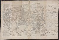
In top margin: Atlas sheet no. 8., In top margin: Geology of the high plateaus of Utah by Capt. C.E. Dutton, U.S.A., Includes "note.", and Relief shown by hachures.
Publisher:
U.S. G.P.O.?,
Subject (Geographic):
Utah--Maps
Subject (Name):
Dutton, Clarence E. (Clarence Edward), 1841-1912. Topographical and geological atlas of the district of the high plateaus of Utah, Geographical and Geological Su, and Geographical and Geological Survey of the Rocky Mountain Region (U.S.)
"Bvt. Maj. Gen. A.A. Humphreys, Chief of Engineers.", "Compiled under the direction of Bvt. Col. Wm. F. Merrill, Maj. Engrs, St. Louis, 1869.", Also shows parts of adjoining states., Includes list of "authorities.", and Relief shown by hachures.
Publisher:
s.n.,
Subject (Geographic):
Colorado--Maps and Utah--Maps
Subject (Name):
Humphreys, A. A. (Andrew Atkinson), 1810-1883, Merrill, Wm. F, R.P. Studley Co, and Sherman, William T. (William Tecumseh), 1820-1891
Geological and Geographical Survey of the Territories (U.S.)
Published / Created:
[1877]
Call Number:
833ca 1878AB
Container / Volume:
BRBL_00585
Image Count:
1
Resource Type:
Maps, Atlases & Globes
Description:
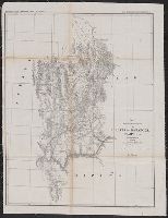
"56" printed in bottom right margin., Backed with linen. Stamp at top "10" crossed out with manuscript "No. 5" below., Relief shown by contours and spot heights., and Shows roads, springs, settlements, etc.
Publisher:
[The Survey],
Subject (Geographic):
Idaho--Maps, Utah--Maps, and Wyoming--Maps
Subject (Name):
Bien, Julius, 1829-1909, Gannett, Henry, 1846-1914, and Hayden, F. V. (Ferdinand Vandeveer), 1829-1887
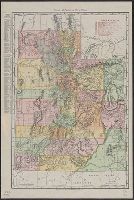
Rand McNally & Co.'s new business atlas map of Utah. and Utah
Description:
Includes index to "Utah principal cities" and index to "Utah railroads.", Other title in bottom left corner: "Rand McNally & Co.'s new business atlas map of Utah.", and Relief shown by hachures.
United States. Army. Corps of Topographical Engineers
Published / Created:
1862?]
Call Number:
836ha 1860
Container / Volume:
BRBL_00593
Image Count:
1
Resource Type:
Maps, Atlases & Globes
Description:
Date inferred from note, "Corrections and additions in reference to railroads in California, etc., were made in January, 1862 ...", In lower right margin: Engraved by W.H. Dougal., Includes list of authorities., Relief shown by shading., and Shows towns, wagon roads, explorers' routes, railroads, forts, etc., from western California to eastern Nebraska, Colorado, and New Mexico.
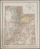
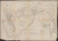
"J.A. Williamson, Commissioner, GLO.", Prime meridians: Greenwich & Washington, D.C., Relief by hachures., and Shows drainage, county boundaries, railroads, railroad grants, military & Indian reservations, township lines, etc.
Publisher:
General Land Office],
Subject (Geographic):
Utah--Maps
Subject (Name):
Bien, Julius, 1826-1909, Davidson, George, 1825-1911. asn CU-BANC, and Roeser, C. (Charles)