United States. Office of Strategic Services. Research and Analysis Branch
Published / Created:
1945.
Call Number:
36eb 1945B
Image Count:
1
Description:
"No. 6381-R & A, OSS, 28 April 1945.", Inset: [Düsseldorf-Münster area]., and "Population data compiled in the Department of State, Division of Geography and Cartography."
Coordinates based on index map ([1] leaf of plates). and On each map: Published according to Act of Parliament by J. Rennell ... [date]; "W. Harrison, sc."
Publisher:
James Rennell
Subject (Geographic):
Bengal (India), Bihar and Orissa (India), India, Bengal., and Bihar and Orissa.
Relief shown pictorially., "Vol. I page 717.", Appears in J. Harris' Navigantium atque itinerantium bibliotheca. 1774-1748., and Prime meridian: London.
Scale 1:633,600; miles, 10 to 1 in; metres, 1609.4 to 1 mile., Relief shown by hachures., and "Entered according to act of Congress in the year 1866 ... "
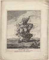
"A grotesque figure, resembling Punch, kneels in profile to the left, with a large thistle in the foreground (right). He bestrides a sack or bundle which rests on the ground, one end forming the 'Mull of Galloway', the other 'St Abbs Head'. The coast-line from the 'Murray Firth' to the 'Firth of Tay' is formed by his hump."--British Museum online catalogue
Alternative Title:
Droll caricature map of Scotland
Description:
Title from item., Publication date from British Museum catalogue., 1 print : etching with engraving and stipple engraving ; sheet 19.8 x 16.2 cm., Printed on wove paper; hand-colored., and Imperfect; sheet trimmed within plate mark resulting in loss of imprint statement from bottom edge.
Publisher:
Printed for Bowles & Carver, No. 69 St Paul's Church Yard
Subject (Geographic):
Scotland
Subject (Topic):
Scots, Ethnic stereotypes, National emblems, Scottish, and Maps
"A grotesque figure, resembling Punch, kneels in profile to the left, with a large thistle in the foreground (right). He bestrides a sack or bundle which rests on the ground, one end forming the 'Mull of Galloway', the other 'St Abbs Head'. The coast-line from the 'Murray Firth' to the 'Firth of Tay' is formed by his hump."--British Museum online catalogue
Alternative Title:
Droll caricature map of Scotland
Description:
Title from item., Publication date from British Museum catalogue., and Mounted to 37 x 28 cm.
Publisher:
Printed for Bowles & Carver, No. 69 St Paul's Church Yard
Subject (Geographic):
Scotland
Subject (Topic):
Scots, Ethnic stereotypes, National emblems, Scottish, and Maps
BEIN 1973 Folio 10: Combined sheets measure 61.0 x 96.8 cm. Bookplate of José M. Rodriguez. No. 15 of 63 maps bound together., BEIN 1977 Folio 191: Imperfect: slight tears, repaired with paper on verso, with no loss of text. Combined sheets measure 63.4 x 91.3 cm. No. 33 of 52 maps bound together., Relief shown pictorially., Includes 33 coats of arms., Bar scales given in "mille pas geometriques, ou milles d'Italie," "lieues communes de France," "lieues d'une heure de Chemin," "lieues communes d'Allemagne," and "lieues communes de Suisse.", and From Alexis Hubert Jaillot's Atlas nouveau, 1692.
Cercle de Franconie, ou sont les Evechés de Wurtzburg, de Bamberg, et d'Aichstet, les Estats du grand Maistre des Chevaliers Teutons, les Marquisats de Cullembach, et d'Ohnspach, les Comtés d'Henneberg, d'Holach, de Reineck, de Wertheim, d'Erpach, de Schwartzenberg, et de Castel, les Baronies de Limpurg, et de Sensheim, et les villes imperiales de Nurenberg, de Rotenburg, de Schweinfurt, Windsheim, et de Weissenburg
Description:
BEIN 1973 Folio 10: Sheet measures 61.3 x 96.6 cm. Bookplate of José M. Rodriguez. No. 30 of 63 maps bound together., Relief shown pictorially., Ferro meridian., Bar scales in Italian miles, common leagues of Germany, great leagues of Germany, common leagues of France, great leagues of France, and leagues of one hours traveling., and Appeared in Jaillot's Atlas françois; cf. Pastoureau, M. Les atlas français, Jaillot II A, 81.
Relief shown pictorially., North oriented down., Bar scale given in unidenified units., Coordinates not present on map and are approximated., Includes index of colleges, buildings, and streets., and Insets: view of Oxforde and a map of Oxfordshire with bar scale in miles.