Skip to search
Skip to main content
Skip to first result
Search
You Searched For
Access
Public
Genre
Maps
New Search
Search Results
Call Number:
1993 72
Collection Title:
Histoire des avanturiers qui sont signalez dans les Indes : contenant ce quils ont fait de plus
Image Count:
1
Found in:
Beinecke Rare Book and Manuscript Library > Carte du continentde L'Ameriqueet de Isles principa ...
Published / Created:
1784
Call Number:
UUzb82 776L
Collection Title:
Jardins anglo-chinois .
Image Count:
1
Resource Type:
Prints & Photographs
Found in:
Beinecke Rare Book and Manuscript Library > Projet d'un jardin Anglo-Francais-Chinois
Creator:
Published / Created:
1728
Call Number:
Efd 728L
Image Count:
6
Found in:
Beinecke Rare Book and Manuscript Library > Nouvelle relation de l'Afrique occidentale: contenant une description exacte du Senegal & des païs situés entre le Cap-Blanc & la riviere de Serrelionne, jusqu'à plus de 300. lieuës en avant dans les terres. L'histoire naturelle de ces païs, les differentes nations qui y sont répanduës, leurs religions & leurs mœurs. Avec l'etat ancien et present des compagnies qui y font le commerce. Ouvrage enrichi de quantite' de cartes, de plans, & de figures en taille-douce. Par le pere Jean-Baptiste Labat ...
Creator:
Published / Created:
1631
Call Number:
Taylor 316
Image Count:
2
Found in:
Beinecke Rare Book and Manuscript Library > Advertisements for the unexperienced planters of New-England, or anywhere, or, The path-way to experience to erect a plantation : With the yearely proceedings of this country in fishing and planting, since the yeare 1614. to the yeare 1630. and their present estate. Also how to prevent the greatest inconveniences, by their proceedings in Virginia, and other plantations, by approved examples. With the countries armes, a description of the coast, harbours, habitations, land-markes, latitude and longitude: with the map, allowed by our royall King Charles. By Captaine Iohn Smith, sometimes governour of Virginia, and admirall of Nevv-England.
Creator:
Published / Created:
[1578]
Call Number:
1976 Folio 2
Image Count:
1
Found in:
Beinecke Rare Book and Manuscript Library > Specvlvum orbis terrarvm.
Creator:
Published / Created:
1835
Call Number:
College Pamphlets 93 4
Image Count:
1
Found in:
Beinecke Rare Book and Manuscript Library > Report of the engineer, upon the preliminary surveys for the Hartford and New-Haven Rail-Road
Creator:
Published / Created:
1746
Call Number:
2002 Folio 94
Image Count:
24
Resource Type:
Maps, Atlases & Globes
Found in:
Beinecke Rare Book and Manuscript Library > A plan of the cities of London and Westminster, and borough of Southwark, with the contiguous buildings / from an actual survey, taken by John Rocque, land-surveyor, and engraved by John Pine ...
Creator:
Published / Created:
[ca. 1870?].
Call Number:
WA MSS S-2247 (BrSides)
Image Count:
1
Found in:
Beinecke Rare Book and Manuscript Library > View of Lander Hill, Austin, Nevada / Lith. by W. H. Rease.
Creator:
Published / Created:
Undated
Call Number:
WA MSS S-2767
Collection Title:
George Chorpenning papers
Container / Volume:
6 (Broadside) | Folder 64
Image Count:
1
Found in:
Beinecke Rare Book and Manuscript Library > Maps
Creator:
Published / Created:
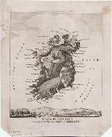
[1793]
Call Number:
793.00.00.04
Image Count:
1
Resource Type:
still image
Found in:
Lewis Walpole Library > Geography bewitched!, or, A droll caricature map of Ireland [graphic].
Branch:v1.60.98 ,Deployed:2024-04-24T10:14:36-04:00