Search
You Searched For
Search Results
- Published / Created:
- 1795
- Call Number:
- 327 1795B
- Container / Volume:
- BRBL_00072
- Image Count:
- 1
- Resource Type:
- Maps, Atlases & Globes
- Found in:
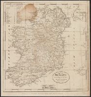
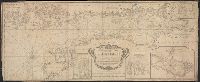
- Beinecke Rare Book and Manuscript Library > A Map of Ireland according to the best authorities.
- Published / Created:
- [1798?]
- Call Number:
- 327 1798
- Container / Volume:
- BRBL_00073
- Image Count:
- 1
- Resource Type:
- Maps, Atlases & Globes
- Found in:
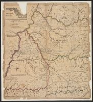
- Beinecke Rare Book and Manuscript Library > A Map of Ireland according to the best authorities. Engraved for Plowden's Historical Review of the State of Ireland.
- Published / Created:
- [1793?]
- Call Number:
- 802 1793
- Container / Volume:
- BRBL_00542
- Image Count:
- 1
- Resource Type:
- Maps, Atlases & Globes
- Found in:
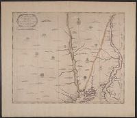
- Beinecke Rare Book and Manuscript Library > A Map of Kentucky, Drawn from Actual Observations. By John Filson.
- Published / Created:
- 1831
- Call Number:
- 764 M52 1831
- Container / Volume:
- BRBL_00458
- Image Count:
- 1
- Resource Type:
- Maps, Atlases & Globes
- Found in:
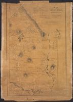
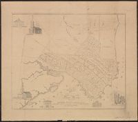
- Beinecke Rare Book and Manuscript Library > A Map of Mendon, Worcester County, Mass. By John Geo. Metcalf, M.D. Newell nelson, Surveyor.
- Creator:
- Tanner, Henry Schenck, 1786-1858
- Published / Created:
- 1822
- Call Number:
- 2003 Folio 81
- Collection Title:
- The New American Atlas ...
- Container / Volume:
- No. IV [4]
- Image Count:
- 1
- Found in:
- Beinecke Rare Book and Manuscript Library > A Map of North America, Constructed According to the Latest Information by H. S. Tanner
- Published / Created:
- [1681]
- Call Number:
- 774 1681
- Container / Volume:
- BRBL_00497
- Image Count:
- 3
- Resource Type:
- Maps, Atlases & Globes
- Found in:
- Beinecke Rare Book and Manuscript Library > A Map of Some of the South and east bounds of Pennsylvania in America ... Sold by John Thornton ... and by John Seller ... London.
- Published / Created:
- [1795]
- Call Number:
- 90 1795A
- Container / Volume:
- BRBL_00661
- Image Count:
- 1
- Resource Type:
- Maps, Atlases & Globes
- Found in:
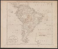
- Beinecke Rare Book and Manuscript Library > A Map of South America According to the best Authorities.
- Published / Created:
- [1834?]
- Call Number:
- 764 SP33 1834
- Container / Volume:
- BRBL_00459
- Image Count:
- 1
- Resource Type:
- Maps, Atlases & Globes
- Found in:
- Beinecke Rare Book and Manuscript Library > A Map of Spencer, Mass. ... by William Baldwin. 1834.
- Published / Created:
- 1755
- Call Number:
- 32 Sa25 1755
- Container / Volume:
- BRBL_00054
- Image Count:
- 1
- Resource Type:
- Maps, Atlases & Globes
- Found in:
- Beinecke Rare Book and Manuscript Library > A Map of St. Sepulchers without Charterhouse Liberty and Clarken Well Parish ... for Ston's Survey.
- Published / Created:
- 1755
- Call Number:
- 771ad Al13 1755
- Container / Volume:
- BRBL_00714
- Image Count:
- 1
- Resource Type:
- Maps, Atlases & Globes
- Found in:
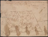
- Beinecke Rare Book and Manuscript Library > A Map of a Tract of 13,000 Acres of Land in the County of Albany on the West Side of Canyadarge Lake granted to David Schuyler and others the 3 June 1755 ... Thomas Palmer, Surv.
- Published / Created:
- [1775?]
- Call Number:
- 76cea 1775
- Container / Volume:
- BRBL_00446
- Image Count:
- 1
- Resource Type:
- Maps, Atlases & Globes
- Found in:
- Beinecke Rare Book and Manuscript Library > A Map of the Coast of New England from Staten Island of Breton; as if was actualy survey'd by Capt. Cyprian Southback.
- Published / Created:
- [1775?]
- Call Number:
- 76cea 1775A
- Container / Volume:
- BRBL_00446
- Image Count:
- 1
- Resource Type:
- Maps, Atlases & Globes
- Found in:
- Beinecke Rare Book and Manuscript Library > A Map of the Coast of New England from Staten Island to the Island of Breton; as it was actualy survey'd by Capt Cyprian Southback.
- Published / Created:
- 1798]
- Call Number:
- 8045 1798B
- Container / Volume:
- BRBL_00546
- Image Count:
- 1
- Resource Type:
- Maps, Atlases & Globes
- Found in:
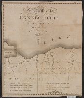
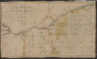
- Beinecke Rare Book and Manuscript Library > A Map of the Connecticut Western Reserve, from actual Survey, By Seath Pease.
- Published / Created:
- 1798
- Call Number:
- 8045 1798A
- Container / Volume:
- BRBL_00546
- Image Count:
- 1
- Resource Type:
- Maps, Atlases & Globes
- Found in:
- Beinecke Rare Book and Manuscript Library > A Map of the Connecticut Western Reserve, from actual Survey, by Seth Pease & Abn. Tappen.
- Published / Created:
- 1704
- Call Number:
- Cxb e678ge
- Collection Title:
- The history of the bucaniers of America : from the first original down to this time; written in
- Image Count:
- 1
- Resource Type:
- Maps, Atlases & Globes
- Found in:
- Beinecke Rare Book and Manuscript Library > A Map of the Countrey and Citty of Panama. Part 3: Chap: 5.
- Published / Created:
- 1795]
- Call Number:
- 18 1795A
- Container / Volume:
- BRBL_00012
- Image Count:
- 1
- Resource Type:
- Maps, Atlases & Globes
- Found in:
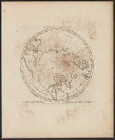
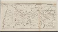
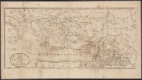
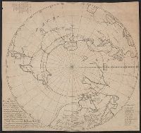
- Beinecke Rare Book and Manuscript Library > A Map of the Countries situate about the North Pole as far as the 50th Degree of North Latitude. W. Barker, sculp.
- Published / Created:
- 1795]
- Call Number:
- 18 1795
- Container / Volume:
- BRBL_00012
- Image Count:
- 1
- Resource Type:
- Maps, Atlases & Globes
- Found in:
- Beinecke Rare Book and Manuscript Library > A Map of the Countries situate about the North Pole as far as the 50th Degree of North Latitude. W. Barker, sculp.
- Published / Created:
- [1770?]
- Call Number:
- 771ad C38 1770
- Container / Volume:
- BRBL_00714
- Image Count:
- 1
- Resource Type:
- Maps, Atlases & Globes
- Found in:
- Beinecke Rare Book and Manuscript Library > A Map of the County of Charlotte.
- Published / Created:
- 1866
- Call Number:
- 304 1866
- Container / Volume:
- BRBL_00033
- Image Count:
- 1
- Resource Type:
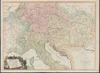
- Maps, Atlases & Globes
- Found in:
- Beinecke Rare Book and Manuscript Library > A Map of the Germanic Confederation as it existed in June, 1866 and of Central Europe.
- Creator:
- Stockdale, John, 1749?-1814
- Published / Created:
- 1800 Nov. 24
- Call Number:
- CF1921 E38 1801
- Collection Title:
- An historical survey of the island of Saint Domingo, together with an account of the Maroon negroes
- Image Count:
- 1
- Resource Type:
- Maps, Atlases & Globes
- Found in:
- Beinecke Rare Book and Manuscript Library > A Map of the Island of St. Domingo
- Published / Created:
- 1768
- Call Number:
- 771 Al13 1768
- Container / Volume:
- BRBL_00713
- Image Count:
- 2
- Resource Type:
- Maps, Atlases & Globes
- Found in:
- Beinecke Rare Book and Manuscript Library > A Map of the Lands Adjoining the Partition Line between Countys of Albany & Ulster Done of New York, 1768, Will Cockburn.
- Published / Created:
- 1765
- Call Number:
- 771 Al13 1765
- Container / Volume:
- BRBL_00713
- Image Count:
- 2
- Resource Type:
- Maps, Atlases & Globes
- Found in:
- Beinecke Rare Book and Manuscript Library > A Map of the Lands on the Southside of the County of Albany between the Blue Mountains and the Sawkill. Surred in the month of Oct. 1765, by Will Cockburn.
- Published / Created:
- [1785?]
- Call Number:
- 755 1785F
- Container / Volume:
- BRBL_00435
- Image Count:
- 1
- Resource Type:
- Maps, Atlases & Globes
- Found in:
- Beinecke Rare Book and Manuscript Library > A Map of the North West parts of the United States of America ... [by] John Fitch ...
- Published / Created:
- [1790?]
- Call Number:
- 32 1790
- Container / Volume:
- BRBL_00044
- Image Count:
- 1
- Resource Type:
- Maps, Atlases & Globes
- Found in:
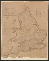
- Beinecke Rare Book and Manuscript Library > A Map of the Roads of England and Wales.
- Published / Created:
- [1795]
- Call Number:
- 801 1795
- Container / Volume:
- BRBL_00541
- Image Count:
- 1
- Resource Type:
- Maps, Atlases & Globes
- Found in:
- Beinecke Rare Book and Manuscript Library > A Map of the Tennassee State formerly Part of North Carolina taken Chiefly from Survey by Genl. Smith & others.
- Published / Created:
- [1831?]
- Call Number:
- 764 B63 1831
- Container / Volume:
- BRBL_00454
- Image Count:
- 1
- Resource Type:
- Maps, Atlases & Globes
- Found in:
- Beinecke Rare Book and Manuscript Library > A Map of the Town of Bolton in the County of Worcester and the Commonwealth of Massachusetts. Surveyed by Silas Holman in the Year 1831.
- Published / Created:
- 1783
- Call Number:
- Cb21 35B
- Collection Title:
- History of the war with America, France, Spain, and Holland; commencing in 1775 and ending in 1783
- Image Count:
- 1
- Found in:
- Beinecke Rare Book and Manuscript Library > A Map of the United States of America, as settled by the peace of 1783
- Published / Created:
- 1809
- Call Number:
- 755 1809A
- Container / Volume:
- BRBL_00438
- Image Count:
- 1
- Resource Type:
- Maps, Atlases & Globes
- Found in:
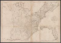
- Beinecke Rare Book and Manuscript Library > A Map of the United States: compiled chiefly from the State Maps, and other Authentic Information, by Saml. Lewis.
- Published / Created:
- 1795
- Call Number:
- 11 1795
- Container / Volume:
- BRBL_00006
- Image Count:
- 1
- Resource Type:
- Maps, Atlases & Globes
- Found in:
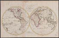
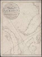
- Beinecke Rare Book and Manuscript Library > A Map of the World from the best Authorities.
- Call Number:
- Zd 147
- Collection Title:
- The history of the Five Indian nations of Canada : which are dependent on the province of New-York
- Image Count:
- 1
- Found in:
- Beinecke Rare Book and Manuscript Library > A Map of the country of the Five Nations, belonging to the province of New York; and of the lakes near which the nations of far Indians live, with part of Canada
- Published / Created:
- 1757
- Call Number:
- 36hc P88 1756
- Container / Volume:
- BRBL_00134
- Image Count:
- 1
- Resource Type:
- Maps, Atlases & Globes
- Found in:
- Beinecke Rare Book and Manuscript Library > A Map of the country round Prague ... : A Plan of the city of Prague ...
- Creator:
- J. F. L
- Call Number:
- 1998 2141
- Collection Title:
- Der ausfuehrlichen nachrichten von der koeniglich-gross-britannischen colonie saltzburgischer
- Image Count:
- 1
- Found in:
- Beinecke Rare Book and Manuscript Library > A Map of the county of Savannah
- Published / Created:
- [1774]
- Call Number:
- 76 1774
- Container / Volume:
- BRBL_00729
- Image Count:
- 1
- Resource Type:
- Maps, Atlases & Globes
- Found in:
- Beinecke Rare Book and Manuscript Library > A Map of the most inhabited part of New England [cartographic material] : containing the provinces of Massachusets Bay and New Hampshire with the colonies of Conecticut and Rhode Island divided into counties and townships : The whole composed from actual
- Published / Created:
- [1774]
- Call Number:
- 76 1774
- Container / Volume:
- BRBL_00729
- Image Count:
- 2
- Resource Type:
- Maps, Atlases & Globes
- Found in:
- Beinecke Rare Book and Manuscript Library > A Map of the most inhabited part of New England [cartographic material] : containing the provinces of Massachusets Bay and New Hampshire with the colonies of Conecticut and Rhode Island divided into counties and townships : The whole composed from actual
- Published / Created:
- [1774]
- Call Number:
- 76 1774
- Container / Volume:
- BRBL_00443
- Image Count:
- 2
- Resource Type:
- Maps, Atlases & Globes
- Found in:
- Beinecke Rare Book and Manuscript Library > A Map of the most inhabited part of New England [cartographic material] : containing the provinces of Massachusets Bay and New Hampshire with the colonies of Conecticut and Rhode Island divided into counties and townships : The whole composed from actual
- Call Number:
- Egf 789
- Collection Title:
- The American geography; or, A view of the present situation of the United States of America
- Image Count:
- 1
- Found in:
- Beinecke Rare Book and Manuscript Library > A Map of the northern and middle states; comprehending the western Territory and the British dominions in North America. Compiled from the best authorities
- Creator:
- Doolittle, Amos, 1754-1832
Purcell, Joseph
- Published / Created:
- 1788
- Call Number:
- Egf 789
- Collection Title:
- The American geography; or, A view of the present situation of the United States of America
- Image Count:
- 1
- Found in:
- Beinecke Rare Book and Manuscript Library > A Map of the states of Virginia, North Carolina South Carolina and Georgia comprehending the Spanish provinces of east and west Florida exhibiting the boundaries as fixed by the late Treaty of Peace between the United States and the Spanish dominions comp
- Call Number:
- Taylor 376
- Collection Title:
- The discoveries of John Lederer : in three several marches from Virginia, to the west of Carolina
- Image Count:
- 1
- Found in:
- Beinecke Rare Book and Manuscript Library > A Map of the whole territory traversed by John Lederer in his three marches
- Published / Created:
- 1719
- Call Number:
- Defoe 50 719db 1
- Collection Title:
- The life and strange surprizing adventures of Robinson Crusoe, of York, mariner : who lived eight
- Image Count:
- 1
- Resource Type:
- Maps, Atlases & Globes
- Found in:
- Beinecke Rare Book and Manuscript Library > A Map of the world, on wch is delineated the voyages of Robinson Cruso
- Published / Created:
- [1795?]
- Call Number:
- 51 50 A.D.
- Container / Volume:
- BRBL_00280
- Image Count:
- 1
- Resource Type:
- Maps, Atlases & Globes
- Found in:
- Beinecke Rare Book and Manuscript Library > A Map of those Countries in which the Apostles Travelled: in propagating Christianity. Compiled and Engraved by Joseph T. Scott.
- Published / Created:
- 1797
- Call Number:
- 771 N49 1797
- Container / Volume:
- BRBL_00484
- Image Count:
- 1
- Resource Type:
- Maps, Atlases & Globes
- Found in:
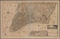
- Beinecke Rare Book and Manuscript Library > A New & Accurate Plan of the City of New York in the State of New York in North America. Published in 1797.
- Published / Created:
- [1790?]
- Call Number:
- 3191 1790A
- Container / Volume:
- BRBL_00041
- Image Count:
- 1
- Resource Type:
- Maps, Atlases & Globes
- Found in:
- Beinecke Rare Book and Manuscript Library > A New & Correct Map of Six Hundred Miles around London, with the Roads & Post Miles in England, Ireland & Scotland, and the Post Leagues in France.
- Published / Created:
- [1780]
- Call Number:
- 32 L84 1780
- Container / Volume:
- BRBL_00048
- Image Count:
- 1
- Resource Type:
- Maps, Atlases & Globes
- Found in:
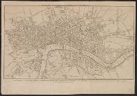
- Beinecke Rare Book and Manuscript Library > A New & Correct Plan of the Cities of London and Westminister, with the Borough of Southwark ...
- Published / Created:
- 1818
- Call Number:
- 755cea 1818
- Container / Volume:
- BRBL_00442
- Image Count:
- 4
- Resource Type:
- Maps, Atlases & Globes
- Found in:
- Beinecke Rare Book and Manuscript Library > A New Chart of America, by Robt. Blachford. To His Excellency James Monroe ...
- Published / Created:
- [1821?]
- Call Number:
- 7645cea 1821
- Container / Volume:
- BRBL_00463
- Image Count:
- 1
- Resource Type:
- Maps, Atlases & Globes
- Found in:
- Beinecke Rare Book and Manuscript Library > A New Chart of Nantucket Shoals & George's Bank with the adjacent coast drawn from the latest authorities. 2nd Edition. By Samuel Lambert. Salem. Cushing, Appleton & S. Lambert, of the State of Mass. Corrected June 1821.
- Published / Created:
- 1755
- Call Number:
- 21 1755
- Container / Volume:
- BRBL_00014
- Image Count:
- 1
- Resource Type:
- Maps, Atlases & Globes
- Found in:
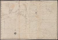
- Beinecke Rare Book and Manuscript Library > A New Chart of the Vast Atlantic Ocean; Exhibiting the Seat of War, both in Europe and America ...
- Published / Created:
- 1755
- Call Number:
- 21 1755
- Container / Volume:
- BRBL_00014
- Image Count:
- 1
- Resource Type:
- Maps, Atlases & Globes
- Found in:
- Beinecke Rare Book and Manuscript Library > A New Chart of the Vast Atlantic Ocean; Exhibiting the Seat of War, both in Europe and America ...
- Published / Created:
- 1794
- Call Number:
- 11 1794A
- Container / Volume:
- BRBL_00006
- Image Count:
- 1
- Resource Type:
- Maps, Atlases & Globes
- Found in:
- Beinecke Rare Book and Manuscript Library > A New Chart of the World ... with the tracks of the British Circumnavigators Bryon, Wallis, Carteret and Cook, &c.
- Published / Created:
- 1831
- Call Number:
- 911cea 1831
- Container / Volume:
- BRBL_00670
- Image Count:
- 1
- Resource Type:
- Maps, Atlases & Globes
- Found in:
- Beinecke Rare Book and Manuscript Library > A New General Chart of the Coast of Brazil ... order of the Portuguese Government ... by Joseph Foss Dessiou ... London by W. Faden ... 1818.
- Published / Created:
- 1792
- Call Number:
- 326 1792
- Container / Volume:
- BRBL_00069
- Image Count:
- 1
- Resource Type:
- Maps, Atlases & Globes
- Found in:
- Beinecke Rare Book and Manuscript Library > A New Geographical Game exhibiting a complete Tour through Scotland and the Western Isles. Neele Sc.
- Published / Created:
- 1750
- Call Number:
- 3218 1750A
- Container / Volume:
- BRBL_00057
- Image Count:
- 1
- Resource Type:
- Maps, Atlases & Globes
- Found in:
- Beinecke Rare Book and Manuscript Library > A New Improved Map of Oxfordshire ... Thos. Kitchin ... 1750.
- Published / Created:
- 1803
- Call Number:
- 85 1803C
- Container / Volume:
- BRBL_00637
- Image Count:
- 1
- Resource Type:
- Maps, Atlases & Globes
- Found in:
- Beinecke Rare Book and Manuscript Library > A New MAp of the West India Isles, from the latest authorities.
- Published / Created:
- 1704
- Call Number:
- 1973 Folio 70
- Collection Title:
- A new sett of maps, both of antient and present geography ... Together with a Geographical treatise
- Image Count:
- 1
- Resource Type:
- Maps, Atlases & Globes
- Found in:
- Beinecke Rare Book and Manuscript Library > A New Map of North America Shewing its Principal Divisions, Chief Cities, Townes, Rivers, Mountains &c. Dedicated to His Highness William Duke of Glocester
- Published / Created:
- 1811
- Call Number:
- 3247 1811
- Container / Volume:
- BRBL_00066
- Image Count:
- 1
- Resource Type:
- Maps, Atlases & Globes
- Found in:
- Beinecke Rare Book and Manuscript Library > A New Map of Northamptonshire, Divided Into Hundreds ... by John Cary.
- Published / Created:
- 1811
- Call Number:
- 3251 1811
- Container / Volume:
- BRBL_00067
- Image Count:
- 1
- Resource Type:
- Maps, Atlases & Globes
- Found in:
- Beinecke Rare Book and Manuscript Library > A New Map of Rutlandshire, Divided into Hundreds ... By John Cary.
- Published / Created:
- [1795?]
- Call Number:
- 90 1795
- Container / Volume:
- BRBL_00661
- Image Count:
- 1
- Resource Type:
- Maps, Atlases & Globes
- Found in:
- Beinecke Rare Book and Manuscript Library > A New Map of South America ....
- Published / Created:
- 1704
- Call Number:
- 1973 Folio 70
- Collection Title:
- A new sett of maps, both of antient and present geography ... Together with a Geographical treatise
- Image Count:
- 1
- Resource Type:
- Maps, Atlases & Globes
- Found in:
- Beinecke Rare Book and Manuscript Library > A New Map of South America; Shewing its General Divisions, Chief Cities, Towns; Rivers, Mountains &c. Dedicated to His Highness William Duke of Gloucester
- Published / Created:
- 1801
- Call Number:
- 501 1801
- Container / Volume:
- BRBL_00276
- Image Count:
- 1
- Resource Type:
- Maps, Atlases & Globes
- Found in:
- Beinecke Rare Book and Manuscript Library > A New Map of Turkey in Asia divided into its provinces, from the best authorities. By John Cary, Engraver.
- Published / Created:
- 1811
- Call Number:
- 27 1811
- Container / Volume:
- BRBL_00023A
- Image Count:
- 1
- Resource Type:
- Maps, Atlases & Globes
- Found in:
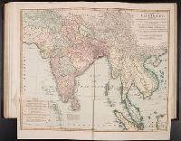
- Beinecke Rare Book and Manuscript Library > A New Map of the East India Isles ... John Cary, Engraver.
- Published / Created:
- 1801
- Call Number:
- 27 1801
- Container / Volume:
- BRBL_00023A
- Image Count:
- 1
- Resource Type:
- Maps, Atlases & Globes
- Found in:
- Beinecke Rare Book and Manuscript Library > A New Map of the East India Isles. From the Latest Authorities. By John Cary, Engraver.
- Published / Created:
- 1701
- Call Number:
- 501 1701
- Container / Volume:
- BRBL_00275
- Image Count:
- 1
- Resource Type:
- Maps, Atlases & Globes
- Found in:
- Beinecke Rare Book and Manuscript Library > A New Map of the Eastern Parts of Asia Minor ...
- Published / Created:
- 1794
- Call Number:
- 534 1794
- Container / Volume:
- BRBL_00289
- Image Count:
- 1
- Resource Type:
- Maps, Atlases & Globes
- Found in:
- Beinecke Rare Book and Manuscript Library > A New Map of the Empire of Persia from Monsr. DAnville ... with several Additions and Emendations.
- Published / Created:
- 1701]
- Call Number:
- 51 1701
- Container / Volume:
- BRBL_00278
- Image Count:
- 1
- Resource Type:
- Maps, Atlases & Globes
- Found in:
- Beinecke Rare Book and Manuscript Library > A New Map of the Land of Canaan ...
- Published / Created:
- 1704
- Call Number:
- 1973 Folio 70
- Collection Title:
- A new sett of maps, both of antient and present geography ... Together with a Geographical treatise
- Image Count:
- 1
- Resource Type:
- Maps, Atlases & Globes
- Found in:
- Beinecke Rare Book and Manuscript Library > A New Map of the Most Considerable Plantations of the English in America. Dedicated to His Highness William Duke of Glocester
- Published / Created:
- [1749?]
- Call Number:
- 7855 1749
- Container / Volume:
- BRBL_00515
- Image Count:
- 1
- Resource Type:
- Maps, Atlases & Globes
- Found in:
- Beinecke Rare Book and Manuscript Library > A New Mapp of Carolina By John Thornton at ye Platt in ye Minories And Will: Fisher at ye Postorn Gate on Towerhill, London.
- Published / Created:
- 1770?]
- Call Number:
- 501 1770
- Container / Volume:
- BRBL_00275
- Image Count:
- 1
- Resource Type:
- Maps, Atlases & Globes
- Found in:
- Beinecke Rare Book and Manuscript Library > A New and Accurate Map of Anatolia or Asia Minor with Syria and such other Provinces of the Turkish Empire as border thereupon ... By Eman. Bowen.
- Published / Created:
- 1794
- Call Number:
- 755cea 1794
- Container / Volume:
- BRBL_00441
- Image Count:
- 4
- Resource Type:
- Maps, Atlases & Globes
- Found in:
- Beinecke Rare Book and Manuscript Library > A New and Correct Chart of the Coast of New England and New York with the adjacent parts of Nova Scotia and New Brunswick from Cape Sable to the entrance of Hudsons or North River by Captain Holland.
- Published / Created:
- [1764?]
- Call Number:
- 76cea 1764
- Container / Volume:
- BRBL_00446
- Image Count:
- 1
- Resource Type:
- Maps, Atlases & Globes
- Found in:
- Beinecke Rare Book and Manuscript Library > A New and Correct Chart of the Sea Coast of New-England, from Cape Codd to Casco Bay. Lately Surbey'd by Capt. Henry Barnsley.
- Published / Created:
- 1794
- Call Number:
- 303cea 1794
- Container / Volume:
- BRBL_00033
- Image Count:
- 1
- Resource Type:
- Maps, Atlases & Globes
- Found in:
- Beinecke Rare Book and Manuscript Library > A New and Correct chart of the Gulf of Finland ... Published by command of the Empress of all the Russias.
- Published / Created:
- [1711?]
- Call Number:
- 90 1711B
- Image Count:
- 1
- Found in:
- Beinecke Rare Book and Manuscript Library > A New and Exact map of the coast, countries and Islands within ye limits of ye South Sea Company ... Herman Moll, Geographer
- Published / Created:
- 1743
- Call Number:
- 319 1743
- Container / Volume:
- BRBL_00040
- Image Count:
- 1
- Resource Type:
- Maps, Atlases & Globes
- Found in:
- Beinecke Rare Book and Manuscript Library > A New and exact map of Great Britain ... [Including Ireland].
- Call Number:
- CE143 A28
- Collection Title:
- An account of the Spanish settlements in America. In four parts ... To which is annexed, a succinct
- Image Count:
- 1
- Found in:
- Beinecke Rare Book and Manuscript Library > A New general map of America drawn from several accurate particular maps and charts and regulated by astronomical observations
- Published / Created:
- [1823?]
- Call Number:
- 1978 Folio 104
- Collection Title:
- A new and elegant imperial atlas: comprehending general and particular maps of every part of the
- Image Count:
- 1
- Found in:
- Beinecke Rare Book and Manuscript Library > A New general map of the East Indies, exhibiting in the Peninsula on this side of the Ganges or Hindoostan, the several partitions of the Mogul's Empire ...
- Published / Created:
- 1811
- Call Number:
- 319 1811
- Container / Volume:
- BRBL_00040
- Image Count:
- 1
- Resource Type:
- Maps, Atlases & Globes
- Found in:
- Beinecke Rare Book and Manuscript Library > A New map of the British Isles ... By John Cary, Engraver.
- Published / Created:
- 1793
- Call Number:
- 304gmd 1793
- Container / Volume:
- BRBL_00034B
- Image Count:
- 1
- Resource Type:
- Maps, Atlases & Globes
- Found in:
- Beinecke Rare Book and Manuscript Library > A New map of the Emperor's Dominions exhibiting the Post Roads of Germany, Hungary, and the Netherlands ... parts of France, Italy, Switzerland and Poland ...
- Published / Created:
- 1790
- Call Number:
- 755 1790A
- Container / Volume:
- BRBL_00435
- Image Count:
- 1
- Resource Type:
- Maps, Atlases & Globes
- Found in:
- Beinecke Rare Book and Manuscript Library > A Particular Map of the American Lakes, Rivers, &c. Par le Sr. D'Anville. Drawn & Engraved for John Harrison.
- Published / Created:
- 1828
- Call Number:
- 38GMD 1828
- Container / Volume:
- BRBL_00171
- Image Count:
- 1
- Resource Type:
- Maps, Atlases & Globes
- Found in:
- Beinecke Rare Book and Manuscript Library > A Physical and Topographical map of France ... the post Roads & Relays ... inland Navigation &c. Pickett Sculp. J. Smith Delin.
- Published / Created:
- 1776
- Call Number:
- 792cea Am32 1776
- Container / Volume:
- BRBL_00519
- Image Count:
- 1
- Resource Type:
- Maps, Atlases & Globes
- Found in:
- Beinecke Rare Book and Manuscript Library > A Plan of Amelia Harbour and Barr in east Florida ...
- Published / Created:
- [1790]
- Call Number:
- 785cea C17 1790
- Container / Volume:
- BRBL_00715
- Image Count:
- 1
- Resource Type:
- Maps, Atlases & Globes
- Found in:
- Beinecke Rare Book and Manuscript Library > A Plan of Cape Fear River from the Bar to Brunswick. [By Robert Sayer].
- Published / Created:
- 1786
- Call Number:
- 326 Ed43 1786
- Container / Volume:
- BRBL_00070
- Image Count:
- 1
- Resource Type:
- Maps, Atlases & Globes
- Found in:
- Beinecke Rare Book and Manuscript Library > A Plan of Edinburgh and the country adjacent ... by John Laurie ...
- Published / Created:
- 1777
- Call Number:
- 774hc M88 1777A
- Container / Volume:
- BRBL_00714
- Image Count:
- 1
- Resource Type:
- Maps, Atlases & Globes
- Found in:
- Beinecke Rare Book and Manuscript Library > A Plan of Mud Island and Fort Mifflin with the Siege thereof, and its Evacuation the 15th of November 1777. Also Red Bank with the Shoals Banks Islands & Flats in the Extent. Drawn by Charles Blaskowitz, Captain of Guides & Pioneers.
- Published / Created:
- 1776
- Call Number:
- 786cea P838 1776
- Container / Volume:
- BRBL_00516
- Image Count:
- 1
- Resource Type:
- Maps, Atlases & Globes
- Found in:
- Beinecke Rare Book and Manuscript Library > A Plan of Port Royal in South Carolina ...
- Published / Created:
- 1782
- Call Number:
- 783hc Y82 1782
- Container / Volume:
- BRBL_00512
- Image Count:
- 2
- Resource Type:
- Maps, Atlases & Globes
- Found in:
- Beinecke Rare Book and Manuscript Library > A Plan of the Posts of York And Gloucester in the province of Virginia, Established by his MAjesty's Army under the Command of Lieuttt. General Earl Cornwallis, together with the Attacks and operations of the American & French Forces Commanded by General
- Published / Created:
- [1800?]
- Call Number:
- 785 N423 1800
- Container / Volume:
- BRBL_00513
- Image Count:
- 1
- Resource Type:
- Maps, Atlases & Globes
- Found in:
- Beinecke Rare Book and Manuscript Library > A Plan of the Town of New Bern and Dryborough ... By Jonathan Price.
- Published / Created:
- [1830?]
- Call Number:
- 764 ST78 1830
- Container / Volume:
- BRBL_00460
- Image Count:
- 1
- Resource Type:
- Maps, Atlases & Globes
- Found in:
- Beinecke Rare Book and Manuscript Library > A Plan of the Town of Stow ... by Augustus Tower in 1830.
- Published / Created:
- 1772
- Call Number:
- 766 L49 1772
- Container / Volume:
- BRBL_00711
- Image Count:
- 1
- Resource Type:
- Maps, Atlases & Globes
- Found in:
- Beinecke Rare Book and Manuscript Library > A Plan of the first Society in Lebanon with the high ways and buildings thereon with the Distance of each house from the Meeting House, also the center of said Society, said Society contains ... Nath. Webb. County Surveyor 1772.
- Published / Created:
- 1848
- Call Number:
- 792fcm 1848
- Container / Volume:
- BRBL_00519
- Image Count:
- 1
- Resource Type:
- Maps, Atlases & Globes
- Found in:
- Beinecke Rare Book and Manuscript Library > A Plat Exhibiting the State of the Surveys in the State of Florida with references.
- Published / Created:
- [1856]
- Call Number:
- 792 1855A
- Container / Volume:
- BRBL_00518
- Image Count:
- 1
- Resource Type:
- Maps, Atlases & Globes
- Found in:
- Beinecke Rare Book and Manuscript Library > A Plat exhibiting the state of the surveys in the State of Florida : with references Surveyor Generals Office St. Augustine Oct. 1855. Approved John Wescott Surveyor General
- Published / Created:
- [1730]
- Call Number:
- 18 1730A
- Container / Volume:
- BRBL_00012
- Image Count:
- 1
- Resource Type:
- Maps, Atlases & Globes
- Found in:
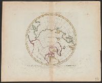
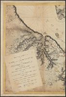
- Beinecke Rare Book and Manuscript Library > A Polar map of part of the northern hemisphere from the latitude of 40 degrees to the Pole.
- Creator:
- Blodget, Samuel, 1724-1807
- Published / Created:
- February the 2d, 1756.
- Call Number:
- 771hc H864 1756
- Container / Volume:
- BRBL_00495
- Image Count:
- 1
- Resource Type:
- Maps, Atlases & Globes
- Found in:
- Beinecke Rare Book and Manuscript Library > A Prospective view of the battle fought near Lake George, on the 8th of Sepr. 1755 : between 2000 English, with 250 Mohawks, under the command of Gen. Johnson: & 2500 French & indians under the command of Genl. Dieskau in which the English were victorious
- Published / Created:
- 1784]
- Call Number:
- 784.00.00.78+
- Image Count:
- 1
- Found in:
- Lewis Walpole Library > A Representation, of the sea fight, on the 5th of Sepr. 1781, between Rear Admiral Graves and the Count de Grasse
- Published / Created:
- 1755
- Call Number:
- 97 L62 1755
- Container / Volume:
- BRBL_00678
- Image Count:
- 1
- Resource Type:
- Maps, Atlases & Globes
- Found in:
- Beinecke Rare Book and Manuscript Library > A Scenographic Plan of the City of the Kings, otherwise called Lima, the capital of the Kingdonm of Peru ... as it was before the late earthquakes.
- Creator:
- Arlidge, Abraham
- Published / Created:
- 1983
- Call Number:
- 32 L84 1694/1983
- Container / Volume:
- BRBL_00739
- Image Count:
- 2
- Resource Type:
- Maps, Atlases & Globes
- Found in:
- Beinecke Rare Book and Manuscript Library > A Survey of Hatton Garden : a suruey of Hatton-Garden belonging to ... Barron Hatton of Kirby / by Abraham Arlidge.
- Published / Created:
- 1776
- Call Number:
- 771 C358 1776C
- Container / Volume:
- BRBL_00482
- Image Count:
- 1
- Resource Type:
- Maps, Atlases & Globes
- Found in:
- Beinecke Rare Book and Manuscript Library > A Survey of Lake Champlain including Lake George, Crown Point, and St. John ... by William Brassier, Draughtsman. 1762.
- Published / Created:
- 1776
- Call Number:
- 771 C358 1776
- Container / Volume:
- BRBL_00482
- Image Count:
- 1
- Resource Type:
- Maps, Atlases & Globes
- Found in:
- Beinecke Rare Book and Manuscript Library > A Survey of Lake Champlain including Lake George, Crown Point, and St. John : surveyed by order of his Excellency major General Sr. Jeffery Amherst ... / by William Brassier, Draughtsman, 1762.
- Creator:
- Brasier, William
- Published / Created:
- 1776
- Call Number:
- Cb23 27
- Collection Title:
- The American military pocket atlas : being an approved collection of correct maps, both general and
- Image Count:
- 1
- Found in:
- Beinecke Rare Book and Manuscript Library > A Survey of Lake Champlain, including Lake George, Crown Point and St. John. Surveyed by order of His Excellency Major General Sr. Jeffery Amherst, knight of the most honble. Order of the Bath, Commander in Chief of His Majesty's forces in North America (now Lord Amherst) by William Brassier, draughtsman, 1762
- Published / Created:
- 1776
- Call Number:
- 771 H864 1776A
- Container / Volume:
- BRBL_00483
- Image Count:
- 1
- Resource Type:
- Maps, Atlases & Globes
- Found in:
- Beinecke Rare Book and Manuscript Library > A Topographical map of Hudsons River ... Communication with Canada by Lake George and lake Champlain ... by Claude Joseph Sauthier ...