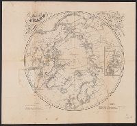
Adam and Charles Black (Firm) Aikman, George, engraver Barlow, Peter, 1776-1862
Published / Created:
1854]
Call Number:
11 1854
Container / Volume:
BRBL_00009
Image Count:
1
Resource Type:
Maps, Atlases & Globes
Description:
In lower right margin: Engd. by G. Aikman., Plate III-I from: General atlas of the world. Edinburgh : A. and C. Black, 1854., Prime meridian: Greenwich., and World map showing magnetic curves.
Depths shown by soundings., Engraved by John and William W. Warr., Insets: Tide tables for Chesapeake Bay and Delaware Bay; profile shore views of Cape Henry, Smiths Point Light House, Windmill Point, and the coast north of Cape Henlopen., and Label on front and
Publisher:
[F. Lucas],
Subject (Geographic):
Chesapeake Bay (Maryland and Virginia)--Maps and Delaware Bay (Delaware and New Jersey)--Maps
Lucas, Fielding, 1781-1854 Warr, John, b. ca. 1798 Warr, William W
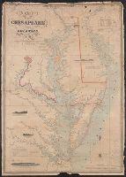
Published / Created:
[1862], c1852
Call Number:
21cea 1862
Image Count:
1
Resource Type:
Maps, Atlases & Globes
Alternative Title:
Chesapeake and Delaware Bays.
Description:
"Drawn by F. Lucas, Jr.", "Engraved by John and William W. Warr, Philadelphia.", "Sold by Lucas Brothers.", Depths shown by soundings and shading., and Includes views: View of the coast from Indian River to Cape Henlopen [Del.] -- Windmill Point [Va.] -- Smiths P
Publisher:
Fielding Lucas,
Subject (Geographic):
Chesapeake Bay Region (Md. and Va.)--Maps and Delaware Bay Region (Del. and N.J.)--Maps
Subject (Topic):
Coasts--Delaware--Maps, Coasts--Maryland--Maps, Coasts--New Jersey--Maps, and Coasts--Virginia--Maps
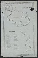
Chao Phraya River base map. and Menam Chow P'aya or Bangkok River
Description:
Includes index of temples, forts, and other buildings., Index information overprinted onto Chao Phraya River base map., and Shows Bangkok and the Chao Phraya River to its mouth on the Gulf of Thailand.
Publisher:
s.n.,
Subject (Geographic):
Bangkok (Thailand)--Maps and Chao Phraya River (Thailand)--Maps