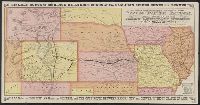
Advertisements, text, and timetables on verso., Includes distance table and text., Latest year mentioned in text on verso: 1877., and Relief shown pictorially.
Publisher:
s.n.,
Subject (Name):
Kansas Pacific Railway Company, Kansas Pacific Railway Company--Maps, and Woodward, Tiernan, and Hale
Red River, Sabine & Western Railway and Red River, Sabine and Western Railway
Description:
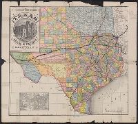
"I.[?] C. Terry, Chf. Eng.", Covers Texas and Louisiana, and parts of New Mexico, Indian Territory, Arkansas, Mississippi, and northern Mexico., From the Streeter collection., and Library's copy imperfect: Holes in center.
Publisher:
s.n.,
Subject (Name):
Red River, Sabine and Western Railway--Maps and Streeter, Thomas W.--(Thomas Winthrop),--1883-1965--Ownership
Subject (Topic):
Coal--Texas--Maps, Forests and forestry--Louisiana--Maps, Forests and forestry--Texas--Maps, Iron--Texas--Maps, Petroleum--Texas--Maps, Railroads--Louisiana--Maps, and Railroads--Texas--Maps
Includes ill. of "Court House, Paris, Texas" and inset of United States., Prime meridians: Greenwich and Washington., and Shows counties, boundary of lands granted to Texas & Pacific Railway, and railroad lines for the Texas & Pacific Railway Co., Fort Worth & Denver City Railway Co., Missouri Pacific Railway Co., Houston & Texas Railway Co., International & Great Northern Railroad, Galveston, Harrisburg & San Antonio Railway Co., Houston, East and West Texas Railway, New Orleans Pacific Railroad Co., and Texas & New Orleans Railroad.
Publisher:
Land Dept. of the Texas & Pacific Railway Co.,
Subject (Geographic):
Texas--Administrative and political divisions--Maps and Texas--Maps
Subject (Name):
Texas & Pacific Railway. Land Dept and Texas & Pacific Railway--Maps
Subject (Topic):
Railroad land grants--Texas--Maps and Railroads--Texas--Maps
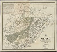
Includes 11 cross sections, inset of railroad outlet routes for anthracite, and list of acreages of workable coal beds., Relief shown by contours., and Shows rock outcrops, limits of coal beds, and lease boundaries.
Subject (Geographic):
Schuylkill County (Pa.)--Maps
Subject (Name):
Brown, Amos P. (Amos Peaslee), 1864-1917 and Elverson, J. S
Subject (Topic):
Coal leases--Pennsylvania--Schuylkill County--Maps and Coal mines and mining--Pennsylvania--Schuylkill County--Maps
"E.L.B. & R.N.C. 1878 no. 2.", Includes inset map of Magadascar., Issued to accompany: A sketch of the modern languages of the East Indies / by Robert Needham Cust. 1878., and Relief shown by hachures and spot heights.
Publisher:
Stanford's Geogl. Estabt.,
Subject (Geographic):
Southeast Asia--Languages--Maps.
Subject (Name):
Cust, Robert Needham, 1821-1909. Sketch of the modern languages of the East Indies.
Also covers part of Pennsylvania, Maryland, Kentucky, and Ohio., Below lower margin at left: A. Hoen & Co. Lith., Include text at upper left & right corners within map border., Includes chart of explanations., Relief shown by hachures., and Shows state and county
Publisher:
West Virginia Geological and Economic Survey?],
Subject (Geographic):
West Virginia--Maps
Subject (Name):
A. Hoen & Co, West Virginia Geological and Economic Survey, and White, I. C. (Israel Charles), 1848-1927
Subject (Topic):
Geology--West Virginia--Maps and Mines and mineral resources--West Virginia