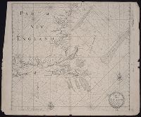
From Robert Sayer and John Bennett's American military pocket atlas (1776)., Imperfect: torn at bottom middle along fold, with some loss of text. Manuscript number of vero: 3., Relief shown pictorially., and Watermark.
Subject (Geographic):
NewEngland--Maps--Early works to 1800
Subject (Name):
Holland, Samuel, 1728-1801, Pownall, Thomas, 1722-1805, and Robert Sayer and John Bennett (Firm). American military pocket atlas
of New-found-land, New-England, New-York, Dellewar-Bay, Virginia, Mary-land and Carrolina, &c
Image Count:
1
Description:
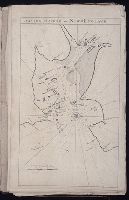
Most maps numbered in pencil on verso, some on recto.
Subject (Geographic):
NewEngland --Maps --Early works to
Subject (Topic):
Navigation --Early works to 1800, Pilot guides --Atlantic Coast (U.S.) --Early works to 1800, and Pilot guides --Caribbean Area --Early works to 1800
Collection Created:
London : Printed for John Thornton, at the sign of the England, Scotland, and Ireland, in the Minories, and Richard Mount, at the Postern on Tower-Hill, 1698London : Printed for John Thornton, at the sign of the England, Scotland, and Ireland, in the Minories, and Richard Mount, at the Postern on Tower-Hill, 1698
of New-found-land, New-England, New-York, Dellewar-Bay, Virginia, Mary-land and Carrolina, &c
Image Count:
1
Description:
Most maps numbered in pencil on verso, some on recto.
Subject (Geographic):
Atlantic Ocean --Maps --Early works to 1800 and Boston Harbor (Mass.) --Maps --Early works to 1800
Subject (Topic):
Navigation --Early works to 1800, Pilot guides --Atlantic Coast (U.S.) --Early works to 1800, and Pilot guides --Caribbean Area --Early works to 1800
Collection Created:
London : Printed for John Thornton, at the sign of the England, Scotland, and Ireland, in the Minories, and Richard Mount, at the Postern on Tower-Hill, 1698London : Printed for John Thornton, at the sign of the England, Scotland, and Ireland, in the Minories, and Richard Mount, at the Postern on Tower-Hill, 1698