Search
You Searched For
Search Results
- Creator:
- Bretez, Louis, d. 1738
- Published / Created:
- [1739?]
- Call Number:
- 1973 folio 44
- Collection Title:
- Plan de Paris commence l’annee 1734. Dessine et grave sous les ordres de Messire Michel Etienne
- Image Count:
- 1
- Resource Type:
- Maps, Atlases & Globes
- Found in:
- Beinecke Rare Book and Manuscript Library > [Untitled sectional plan of Paris]
- Creator:
- Bretez, Louis, d. 1738
- Published / Created:
- [1739?]
- Call Number:
- 1973 folio 44
- Collection Title:
- Plan de Paris commence l’annee 1734. Dessine et gravesous les ordres de Messire Michel Etienne
- Image Count:
- 1
- Resource Type:
- Maps, Atlases & Globes
- Found in:
- Beinecke Rare Book and Manuscript Library > [Untitled sectional plan of Paris]
- Published / Created:
- [1808]
- Call Number:
- In W890 Zz808
- Collection Title:
- The history of the rise, progress, and accomplishment of the abolition of the African slave-trade
- Image Count:
- 1
- Resource Type:
- Maps, Atlases & Globes
- Found in:
- Beinecke Rare Book and Manuscript Library > [Untitled map of abolition of the slave trade]
- Creator:
- Des Barres, Joseph F. W. (Joseph Frederick Wallet), 1722-1824
- Published / Created:
- 1775?-1781?]
- Call Number:
- 1983 Folio 25
- Image Count:
- 3
- Resource Type:
- Maps, Atlases & Globes
- Found in:
- Beinecke Rare Book and Manuscript Library > [The Atlantic Neptune : published for the use of the Royal Navy Great Britain / by Joseph F.W. Des Barres, esq.].
- Creator:
- Benitz, A.
- Published / Created:
- [1840]
- Call Number:
- 1973 Folio 105
- Collection Title:
- Atlas fisico y politico de la Republica de Venezuela ... por ... Agustin Codazzi ...
- Image Count:
- 1
- Resource Type:
- Maps, Atlases & Globes
- Found in:
- Beinecke Rare Book and Manuscript Library > [Provincia de Apure]
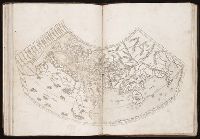
- Published / Created:
- [1490]
- Call Number:
- 1978 Folio 114
- Collection Title:
- Cosmographia. [Translated into Latin by Jacobus Angelus, and edited by Nicolaus Germanus.]
- Image Count:
- 1
- Resource Type:
- Maps, Atlases & Globes
- Found in:
- Beinecke Rare Book and Manuscript Library > [Map depicting Europe, North Africa, the Middle East and Asia].
- Creator:
- Cóvens et Mortier
- Published / Created:
- ca. 1730-ca. 1800]
- Call Number:
- 1973 Folio 71
- Image Count:
- 1
- Resource Type:
- Maps, Atlases & Globes
- Found in:
- Beinecke Rare Book and Manuscript Library > [Atlas nouveau contenant toutes les parties du monde ou sont exactement marqués les empires, monarchies, royaumes, états, republiques &c. Le tout recueilli par les meilleurs geógraphes.]
- Published / Created:
- Undated
- Call Number:
- 1978 595
- Collection Title:
- El atlas abreviado, o Compendiosa geografia, del mvndo antigvo, y nvevo, segun esta oy dividido
- Image Count:
- 1
- Resource Type:
- Maps, Atlases & Globes
- Found in:
- Beinecke Rare Book and Manuscript Library > Yslas Britanicas enque se comprehenden los reynos de Ynglaterra, Escocia, e Yrlanda
- Call Number:
- 1977 +392
- Collection Title:
- A survey of the cities of London and Westminster : containing the original, antiquity, increase
- Image Count:
- 1
- Resource Type:
- Maps, Atlases & Globes
- Found in:
- Beinecke Rare Book and Manuscript Library > Walbrook Ward and Dow Gate Ward with its division into parishes taken from the last surveys
- Call Number:
- 1973 Folio 114
- Collection Title:
- The English pilot: describing the West-India navigation, from Hudson's-Bay to the river Amazones
- Image Count:
- 1
- Resource Type:
- Maps, Atlases & Globes
- Found in:
- Beinecke Rare Book and Manuscript Library > Virginia, Maryland, Pennsilvania, east & west New Jarsey
- Creator:
- Melish, John, 1771-1822. United States of America
Tannen, B
- Published / Created:
- 1821
- Call Number:
- 1996 142
- Collection Title:
- United States directory for the use of travellers and merchants : giving an account of the
- Image Count:
- 1
- Resource Type:
- Maps, Atlases & Globes
- Found in:
- Beinecke Rare Book and Manuscript Library > United States of America compiled from the latest & best authorities
- Creator:
- Blaeu, Joan, 1596-1673. Theatrum orbis terrarum
Blaeu, Willem Janszoon, 1571-1638
Blaeu, Willem Janszoon, 1571-1638. Theatrum orbis terrarum
- Published / Created:
- [ca. 163-?]
- Call Number:
- 1983 Folio 19
- Collection Title:
- [Atlas factice of 96 maps by Blaeu, Visscher, Jansson, Hondius and others]
- Image Count:
- 2
- Resource Type:
- Maps, Atlases & Globes
- Found in:
- Beinecke Rare Book and Manuscript Library > Tvrcicvm imperivm
- Creator:
- Browne, Christopher, fl. 1684-1712, bookseller
Lea, Philip, fl. 1683-1700
Morden, Robert, d. 1703, creator
- Published / Created:
- 1700
- Call Number:
- 1973 Folio 10
- Image Count:
- 1
- Resource Type:
- Maps, Atlases & Globes
- Found in:
- Beinecke Rare Book and Manuscript Library > This actuall survey of London, Westminster & Southwark is humbly dedicated to ye Ld. Mayor [and] Court of Aldermen by Ro. Morden, Phil. Lea, Chr. Browne
- Creator:
- Browne, Christopher, fl. 1684-1712, creator
- Published / Created:
- [1704?]
- Call Number:
- 1973 Folio 10
- Image Count:
- 1
- Resource Type:
- Maps, Atlases & Globes
- Found in:
- Beinecke Rare Book and Manuscript Library > The war in Portugall and Spain: with the harbours of the Groyne, Vigo & Bayonna, Porto, Lisbon [and] St. Ubes, Cadiz, and a chart from England to the streights
- Creator:
- Berry, William, fl. 1669-1708, creator
Sanson, Nicolas, 1600-1667
- Published / Created:
- 1683
- Call Number:
- 1973 Folio 10
- Image Count:
- 1
- Resource Type:
- Maps, Atlases & Globes
- Found in:
- Beinecke Rare Book and Manuscript Library > The states of the empire of the Turks in Europe: subdivided according to ye extent of its governments
- Creator:
- Bry, Theodor de, 1528-1598
- Call Number:
- 1976 Folio 110
- Collection Title:
- The mariners mirrovr wherin may playnly be seen the courses, heights, distances, depths, sounding
- Image Count:
- 1
- Resource Type:
- Maps, Atlases & Globes
- Found in:
- Beinecke Rare Book and Manuscript Library > The sea coastes of the landes of Poyctou and Bordeaux ...as they shew and appeare, when you sayle there alongst betweene Picquelier and the River of Bordeaux called the Garonne
- Creator:
- Bry, Theodor de, 1528-1598
- Call Number:
- 1976 Folio 110
- Collection Title:
- The mariners mirrovr wherin may playnly be seen the courses, heights, distances, depths, sounding
- Image Count:
- 1
- Resource Type:
- Maps, Atlases & Globes
- Found in:
- Beinecke Rare Book and Manuscript Library > The sea coastes of Portugal betwene Camino & Montego eue as the countrie there aboutes is lying and situated with all the havens thereof exactly done, and corected with great dilligence
- Creator:
- Bry, Theodor de, 1528-1598
- Call Number:
- 1976 Folio 110
- Collection Title:
- The mariners mirrovr wherin may playnly be seen the courses, heights, distances, depths, sounding
- Image Count:
- 1
- Resource Type:
- Maps, Atlases & Globes
- Found in:
- Beinecke Rare Book and Manuscript Library > The sea coastes of England, from the Sorlinges by the landes end to Plymouth with the hauens and harbrowghes
- Creator:
- Bry, Theodor de, 1528-1598
- Call Number:
- 1976 Folio 110
- Collection Title:
- The mariners mirrovr wherin may playnly be seen the courses, heights, distances, depths, sounding
- Image Count:
- 1
- Resource Type:
- Maps, Atlases & Globes
- Found in:
- Beinecke Rare Book and Manuscript Library > The sea coastes of England betweene the Ile of Wight & Douer, with the principal hauens thereof according to their situation and appearing
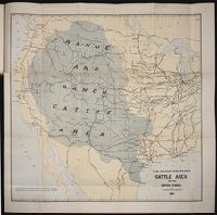
- Published / Created:
- 1884
- Call Number:
- Zc10 885up
- Collection Title:
- Range and ranch cattle
- Image Count:
- 1
- Resource Type:
- Maps, Atlases & Globes
- Found in:
- Beinecke Rare Book and Manuscript Library > The range and ranch cattle area of the United States
- Creator:
- Lea, Philip, fl. 1683-1700, creator
- Published / Created:
- [1696]
- Call Number:
- 1973 Folio 10
- Image Count:
- 1
- Resource Type:
- Maps, Atlases & Globes
- Found in:
- Beinecke Rare Book and Manuscript Library > The principall islands in America belonging to the English empire viz Iamaica, Barbados, Antegoa, St. Christophers [and] Bermudos
- Creator:
- Wyld, James, 1812-1887
- Published / Created:
- 1841
- Call Number:
- 1977 Folio 193
- Collection Title:
- A new general atlas of modern geography, consisting of a complete collection of maps of the four
- Image Count:
- 1
- Resource Type:
- Maps, Atlases & Globes
- Found in:
- Beinecke Rare Book and Manuscript Library > The phenomena of the universe ...
- Call Number:
- 1977 +392
- Collection Title:
- A survey of the cities of London and Westminster : containing the original, antiquity, increase
- Image Count:
- 1
- Resource Type:
- Maps, Atlases & Globes
- Found in:
- Beinecke Rare Book and Manuscript Library > The parish of St. Johns Wapping
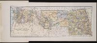
- Published / Created:
- c1889
- Call Number:
- Zc10 889iv
- Collection Title:
- The new states; a sketch of the history and development of the states of North Dakota, South Dakota
- Image Count:
- 1
- Resource Type:
- Maps, Atlases & Globes
- Found in:
- Beinecke Rare Book and Manuscript Library > The new states North Dakota, South Dakota, Montana and Washington
- Creator:
- Waghenaer, Lucas Janszoon, 1534 or 5-1606
- Published / Created:
- ann. 1605.
- Call Number:
- 1976 Folio 46
- Image Count:
- 1
- Resource Type:
- Maps, Atlases & Globes
- Found in:
- Beinecke Rare Book and Manuscript Library > The mariners mirrovr wherin may playnly be seen the courses, heights, distances, depths, sounding, flouds and ebs, risings of lands, rocks ... of the harbouroughs, havens and ports of the greatest part of Europe: ... together w.th the rules and instrumeíÄ
- Creator:
- Berry, William, fl. 1669-1708, creator
Sanson, Nicolas, 1600-1667
- Published / Created:
- [168-?]
- Call Number:
- 1973 Folio 10
- Image Count:
- 1
- Resource Type:
- Maps, Atlases & Globes
- Found in:
- Beinecke Rare Book and Manuscript Library > The kingdom of Hungary and the states that have been subject to it which are now the northern parts of Turkey in Europe
- Creator:
- Berry, William, fl. 1669-1708, creator
Sanson, Nicolas, 1600-1667
- Published / Created:
- [168-]
- Call Number:
- 1973 Folio 10
- Image Count:
- 1
- Resource Type:
- Maps, Atlases & Globes
- Found in:
- Beinecke Rare Book and Manuscript Library > The kingdom of France: distinguished according to the extent of all its provinces and conquests in Spain, Italy, Germany, Flanders, Artoise, Haynoult, Namur, and Luxembourg, provinces of the low countries
- Creator:
- Berry, William, fl. 1669-1708, creator
Sanson, Nicolas, 1600-1667
- Published / Created:
- [1684?]
- Call Number:
- 1973 Folio 10
- Image Count:
- 1
- Resource Type:
- Maps, Atlases & Globes
- Found in:
- Beinecke Rare Book and Manuscript Library > The kingdom of Denmark : subdivided into its principall provinces
- Call Number:
- 1973 Folio 114
- Collection Title:
- The English pilot: describing the West-India navigation, from Hudson's-Bay to the river Amazones
- Image Count:
- 1
- Resource Type:
- Maps, Atlases & Globes
- Found in:
- Beinecke Rare Book and Manuscript Library > The island of Jamaica
- Call Number:
- WeInd Ehc 762J
- Collection Title:
- A description of the Spanish islands and settlements on the coast of the West Indies / compiled
- Image Count:
- 1
- Resource Type:
- Maps, Atlases & Globes
- Found in:
- Beinecke Rare Book and Manuscript Library > The island of Hispaniola called by the French St. Domingo. Subject to France and Spain
- Creator:
- Bowen, Emanuel, d. 1767
- Published / Created:
- 1720
- Call Number:
- 1973 Folio 114
- Collection Title:
- The English pilot: describing the West-India navigation, from Hudson's-Bay to the river Amazones
- Image Count:
- 1
- Resource Type:
- Maps, Atlases & Globes
- Found in:
- Beinecke Rare Book and Manuscript Library > The harbour of Casco Bay and islands adjacent
- Creator:
- Berry, William, fl. 1669-1708, creator
Sanson, Nicolas, 1600-1667
- Published / Created:
- [ca. 1689?]
- Call Number:
- 1973 Folio 10
- Image Count:
- 1
- Resource Type:
- Maps, Atlases & Globes
- Found in:
- Beinecke Rare Book and Manuscript Library > The empire of the great Turke [sic] in Europe, Asia, [and] Africa : divided into all its Beglerbeglicz or governments in which are also distinguished the states that are tributary to him
- Creator:
- Berry, William, fl. 1669-1708, creator
Sanson, Nicolas, 1600-1667
- Published / Created:
- [ca. 1686]
- Call Number:
- 1973 Folio 10
- Image Count:
- 1
- Resource Type:
- Maps, Atlases & Globes
- Found in:
- Beinecke Rare Book and Manuscript Library > The empire of Germany divided according to the extent of all the estates, principalities and soveraignities that are or have been comprehended under the name of Germany
- Creator:
- Berry, William, fl. 1669-1708, creator
Sanson, Nicolas, 1600-1667
- Published / Created:
- [ca. 1689?]
- Call Number:
- 1973 Folio 10
- Image Count:
- 1
- Resource Type:
- Maps, Atlases & Globes
- Found in:
- Beinecke Rare Book and Manuscript Library > The dukedom of Pomerania : divided into it's principall parts
- Creator:
- Berry, William, fl. 1669-1708, creator
Sanson, Nicolas, 1600-1667
- Published / Created:
- [ca. 1684?]
- Call Number:
- 1973 Folio 10
- Image Count:
- 1
- Resource Type:
- Maps, Atlases & Globes
- Found in:
- Beinecke Rare Book and Manuscript Library > The dukedom and electorat of Brandenbourg: which is part of the circle of the higher Saxony, divided into its principall parts
- Creator:
- Berry, William, fl. 1669-1708, creator
- Published / Created:
- [ca. 1689]
- Call Number:
- 1973 Folio 10
- Image Count:
- 1
- Resource Type:
- Maps, Atlases & Globes
- Found in:
- Beinecke Rare Book and Manuscript Library > The course of the river Rhine : from its fountain to its runing into the sea in which is distinguish't all the estates and soveraignities which are upon it and about it
- Creator:
- Berry, William, fl. 1669-1708, creator
- Published / Created:
- [ca. 1689]
- Call Number:
- 1973 Folio 10
- Image Count:
- 1
- Resource Type:
- Maps, Atlases & Globes
- Found in:
- Beinecke Rare Book and Manuscript Library > The circle of Westphalia : divided into all it's states and soveranities
- Creator:
- Berry, William, fl. 1669-1708, creator
Sanson, Nicolas, 1600-1667
- Published / Created:
- [ca. 1686]
- Call Number:
- 1973 Folio 10
- Image Count:
- 1
- Resource Type:
- Maps, Atlases & Globes
- Found in:
- Beinecke Rare Book and Manuscript Library > The circle of Swabia subdivided into all the territories it's composed of
- Creator:
- Berry, William, fl. 1669-1708, creator
Sanson, Nicolas, 1600-1667
- Published / Created:
- [ca. 1686]
- Call Number:
- 1973 Folio 10
- Image Count:
- 1
- Resource Type:
- Maps, Atlases & Globes
- Found in:
- Beinecke Rare Book and Manuscript Library > The circle of Bavaria subdivided into all ye territories it's composed of
- Creator:
- Berry, William, fl. 1669-1708, creator
Sanson, Nicolas, 1600-1667
- Published / Created:
- 1689
- Call Number:
- 1973 Folio 10
- Image Count:
- 1
- Resource Type:
- Maps, Atlases & Globes
- Found in:
- Beinecke Rare Book and Manuscript Library > The circle and electorat of the Rhine : subdivided into all the states that it's composed off [sic]
- Call Number:
- 1977 +392
- Collection Title:
- A survey of the cities of London and Westminster : containing the original, antiquity, increase
- Image Count:
- 1
- Resource Type:
- Maps, Atlases & Globes
- Found in:
- Beinecke Rare Book and Manuscript Library > The Wards of Farington within and Baynards Castle with its divisions into parishes taken from the last survey with corrections
- Creator:
- Berry, William, fl. 1669-1708, creator
Sanson, Nicolas, 1600-1667
- Published / Created:
- [1684?]
- Call Number:
- 1973 Folio 10
- Image Count:
- 1
- Resource Type:
- Maps, Atlases & Globes
- Found in:
- Beinecke Rare Book and Manuscript Library > The United Provinces of the Netherlands : with their conquests in Flanders, Brabant, Limbourg, and Liege, and the places they possessed upon the Rhine in the Dutchy of Cleve and in the Arch-Bishoprick and elector of Colen
- Creator:
- Bowles, Carington, 1724-1793
- Published / Created:
- [1766]
- Call Number:
- ByzL 79t
- Collection Title:
- A new and accurate history and survey of London, Westminster, Southwark, and places adjacent
- Image Count:
- 1
- Resource Type:
- Maps, Atlases & Globes
- Found in:
- Beinecke Rare Book and Manuscript Library > The London guide, or, a pocket plan of the cities of London & Westminster and Borough of Southwark; with the new buildings, &c. to the present year
- Call Number:
- 1977 +392
- Collection Title:
- A survey of the cities of London and Westminster : containing the original, antiquity, increase
- Image Count:
- 1
- Resource Type:
- Maps, Atlases & Globes
- Found in:
- Beinecke Rare Book and Manuscript Library > The Custom House
- Creator:
- Mortier, David
Mortier, Pierre
Sanson, Nicolas, 1600-1667, creator
- Published / Created:
- [1710]
- Call Number:
- 1973 Folio 10
- Image Count:
- 1
- Resource Type:
- Maps, Atlases & Globes
- Found in:
- Beinecke Rare Book and Manuscript Library > Teatre de la guerre en Flandre [et] Brabant, les pays conquis et le Bas-Rhein etc
- Creator:
- Valck, G. (Gerard), 1651 or 2-1726, creator
- Published / Created:
- [169-?]
- Call Number:
- 1973 Folio 10
- Image Count:
- 1
- Resource Type:
- Maps, Atlases & Globes
- Found in:
- Beinecke Rare Book and Manuscript Library > Tabula ducatuum Livoniae et Curlandiae: recentior incisa editaque
- Creator:
- L'Huilier, Joannes, engraver
Wit, Frederik de., creator
- Published / Created:
- [1662]
- Call Number:
- 1973 Folio 10
- Image Count:
- 1
- Resource Type:
- Maps, Atlases & Globes
- Found in:
- Beinecke Rare Book and Manuscript Library > Tabula Indiae orientalis
- Published / Created:
- [1540]
- Call Number:
- E33 +540P
- Collection Title:
- Geographia vniversalis, vetvs et nova complectens Clavdii Ptolemaei Alexandrini enarrationis libros
- Image Count:
- 1
- Resource Type:
- Maps, Atlases & Globes
- Found in:
- Beinecke Rare Book and Manuscript Library > Tabula Europae IX
- Published / Created:
- 1817
- Call Number:
- Folio Q115 H84 1B
- Collection Title:
- Atlas geographique et physique des regions equinoxiales du nouveau continent, fonde sur des
- Image Count:
- 1
- Resource Type:
- Maps, Atlases & Globes
- Found in:
- Beinecke Rare Book and Manuscript Library > Tableau physique des Ils Canaries. Geographie des plantes du Pic de Teneriffe
- Published / Created:
- 1807-08
- Call Number:
- Folio Q115 H84 3A
- Collection Title:
- Atlas geographique et physique du royaume de la Nouvelle-Espagne, fonde sur des observations
- Image Count:
- 1
- Resource Type:
- Maps, Atlases & Globes
- Found in:
- Beinecke Rare Book and Manuscript Library > Tableau physique de la pente Orientale du Plateau de la Nouvelle Espagne (Chemin de Mexico a Veracruz par Puebla et Xalapa.) Dresse d'apres des mesures barometriques et trigonometriques, prises en 1804 par Mr. de Humboldt. pl. 12