Skip to search
Skip to main content
Skip to first result
Search
You Searched For
Date
Unknown
"Africa--Maps--Early works to 1800"
Access
Public
Genre
Maps in books
Date Created
[Missing]
New Search
Search Results
Call Number:
1976 1233
Collection Title:
Forty-two new maps of Asia, Africa, and America ... : all engrav’d, according to the latest
Image Count:
1
Alternative Title:
Africa in general
Description:
In ink on verso: 13.
Subject (Geographic):
Africa --Maps --Early works to 1800
Subject (Name):
Nicholson, John, d. ca. 1717, bookseller
Subject (Topic):
Atlases --Early works to 1800
Collection Created:
London : Printed for J. Nicholson ..., 1716 ...
Found in:
Beinecke Rare Book and Manuscript Library > Africa, according to ye newest and most exact observations
Call Number:
1976 1233
Collection Title:
Forty-two new maps of Asia, Africa, and America ... : all engrav’d, according to the latest
Image Count:
1
Alternative Title:
Zaara, or the Deserts; Negroland, &c
Description:
In ink on verso: 17.
Subject (Geographic):
Africa --Maps --Early works to 1800
Subject (Name):
Nicholson, John, d. ca. 1717, bookseller
Subject (Topic):
Atlases --Early works to 1800
Collection Created:
London : Printed for J. Nicholson ..., 1716 ...
Found in:
Beinecke Rare Book and Manuscript Library > A map of Zaara or the Desart, Negroland & Cape Virde Islands &c
Call Number:
1976 1233
Collection Title:
Forty-two new maps of Asia, Africa, and America ... : all engrav’d, according to the latest
Image Count:
1
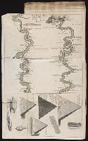
Alternative Title:
The River Nile, with all the pyramids
Description:
Imperfect: tear at bottom center fold with no loss of text., In ink on verso: 15., and Includes "The draught of ye pyramids taken exactly from Mr. Greaves".
Subject (Geographic):
Africa --Maps --Early works to 1800
Subject (Name):
Nicholson, John, d. ca. 1717, bookseller
Subject (Topic):
Atlases --Early works to 1800
Collection Created:
London : Printed for J. Nicholson ..., 1716 ...
Found in:
Beinecke Rare Book and Manuscript Library > An exact map of the River Nile done by Mr. Lucas
Call Number:
1976 1233
Collection Title:
Forty-two new maps of Asia, Africa, and America ... : all engrav’d, according to the latest
Image Count:
1
Alternative Title:
The west part of Barbary
Description:
In ink on verso: 16.
Subject (Geographic):
Africa --Maps --Early works to 1800
Subject (Name):
Nicholson, John, d. ca. 1717, bookseller
Subject (Topic):
Atlases --Early works to 1800
Collection Created:
London : Printed for J. Nicholson ..., 1716 ...
Found in:
Beinecke Rare Book and Manuscript Library > The west part of Barbary containing Fez, Marocco, Algier, and part of Biledulgerid the Canary Islands &c
Call Number:
1976 1233
Collection Title:
Forty-two new maps of Asia, Africa, and America ... : all engrav’d, according to the latest
Image Count:
1
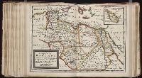
Alternative Title:
The east part of Barbary
Description:
In ink on verso: 14.
Subject (Geographic):
Africa --Maps --Early works to 1800
Subject (Name):
Nicholson, John, d. ca. 1717, bookseller
Subject (Topic):
Atlases --Early works to 1800
Collection Created:
London : Printed for J. Nicholson ..., 1716 ...
Found in:
Beinecke Rare Book and Manuscript Library > The east part of Barbary containing Tunis, Tripoli, Barca, Egypt, Nubia, part of Biledulgerid and Zaara or desart
Creator:
Published / Created:
Undated
Call Number:
Taylor 216A
Collection Title:
Iohn Huighen van Linschoten, his Discours of Voyages into ye Easte & West Indies : deuided into
Image Count:
1
Description:
Bound in following title page of second book. and Map has small tear at bottom fold in center.
Subject (Geographic):
Africa --Maps --Early works to 1800
Subject (Name):
Wolfe, John, d. 1601, printer
Subject (Topic):
Voyages and travels --Early works to 1800
Collection Created:
[London] : Printed at London by [John Windet for] Iohn Wolfe, printer to ye Honorable Cittie of London, [1598]
Found in:
Beinecke Rare Book and Manuscript Library > [Map of southern Africa and Madagascar]
Call Number:
1974 Folio 72
Collection Title:
The English pilot: describing the West-India navigation, from Hudson's-Bay to the river Amazones
Image Count:
1
Subject (Geographic):
Africa --Maps --Early works to 1800
Subject (Topic):
Navigation --Early works to 1800, Pilot guides --Atlantic Coast (U.S.) --Early works to 1800, and Pilot guides --Caribbean Area --Early works to 1800
Collection Created:
London : Printed for W. and J. Mount, T. Page and son, on Tower-Hill, MDCCLX [1760]
Found in:
Beinecke Rare Book and Manuscript Library > A new and correct chart of the western and southern oceans
Call Number:
1973 Folio 116
Collection Title:
The English pilot: describing the West-India navigation, from Hudson's-Bay to the river Amazones
Image Count:
2
Subject (Geographic):
Africa --Maps --Early works to 1800
Subject (Topic):
Navigation --Early works to 1800, Pilot guides --Atlantic Coast (U.S.) --Early works to 1800, and Pilot guides --Caribbean Area --Early works to 1800
Collection Created:
London :
Found in:
Beinecke Rare Book and Manuscript Library > A new and correct chart of the western and southern oceans
Call Number:
1973 Folio 114
Collection Title:
The English pilot: describing the West-India navigation, from Hudson's-Bay to the river Amazones
Image Count:
1
Resource Type:
Maps, Atlases & Globes
Subject (Geographic):
Africa --Maps --Early works to 1800
Subject (Topic):
Navigation --Early works to 1800, Pilot guides --Atlantic Coast (U.S.) --Early works to 1800, and Pilot guides --Caribbean Area --Early works to 1800
Collection Created:
London : Printed for W. and J. Mount, T. Page and son, on Tower-Hill, MDCCLIX [1759]
Found in:
Beinecke Rare Book and Manuscript Library > A new and correct chart of the western and southern oceans ...
Branch:v1.61.6 ,Deployed:2024-06-12T09:55:33-04:00