New and accurate map of Negroland and the adjacent countries
Description:
Includes decorative title cartouche with figures., Prime meridian: London, Relief shown pictorially., Shows boundaries, rivers, and principal settlements, with tents showing areas inhabited by nomads., and Watermark.
Copy 2: Imperfect: two southern sheets wanting. Borders hand colored. Dissected and mounted on linen, 50 x 115 cm. Stamp on verso, "Yale University Library, Karpinski-Von Wieser Map Collection.", Copy 2: Watermarks. Borders hand colored. Stamp on verso of northern sheets: 34. Stamp on verso of southern sheets: 35. Manuscript annotations in 20th century hand on verso of northern sheets., Insets: A particular map of Baffin and Hudson's Bay -- The passage by land to California., Prime meridians: London and Ferro., and Relief shown pictorially.
Publisher:
Publish'd by Laurie & Whittle, No. 53 Fleet Street,
Copy 1: two northern sheets joined and two southern sheets joined. Borders hand colored. Stamps, "Yale, Horace Brown, 1900S.", Copy 1: Watermarks. Borders hand colored. Stamp on verso of northern sheets: 62. Stamp on verso of southern sheets: 63., Insets: A particular map of Baffin and Hudson's Bay -- The passage by land to California., Prime meridians: London and Ferro., and Relief shown pictorially.
Publisher:
Publish'd by Laurie & Whittle, No. 53 Fleet Street,
Copy 3: Interiors hand colored. Stamp on verso of northern sheets: 37. Stamp on verso of southern sheets: 38., Insets: A particular map of Baffin and Hudson's Bay -- The passage by land to California., Prime meridians: London and Ferro., and Relief shown pictorially.
Publisher:
Publish'd by Laurie & Whittle, No. 53 Fleet Street,
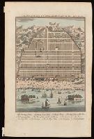
Bird's-eye view of Canton, now Guangzou, China; relief shown pictorially., From: Navigantium atque itinerantium bibliotheca ... / John Harris. -- London : T. Woodward, 1744-1748., In upper right-hand corner: Vol. 1. pa. 359., and Indexed for points on interest.
Publisher:
[T. Woodward],
Subject (Geographic):
Guangzhou (China)--Maps--Early works to 1800.
Subject (Name):
Harris, John, 1667?-1719. Navigantium atque itinerantium bibliotheca.
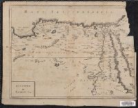
"Octavo, Vol. 2, p. 371" in lower left corner., Imperfect: upper right corner mutilated, with some loss of text. Reinforced on verso with strips of manuscript waste., Relief shown pictorially., and Shows boundaries, rivers and principal settlements.
Publisher:
[publisher not identified],
Subject (Geographic):
Egypt--Historical geography--Early works to 1800--Maps., Egypt--Maps--Early works to 1800., Libya--Historical geography--Early works to 1800--Maps., and Libya--Maps--Early works to 1800.
"Cum gratia et privil. S.R.I. Vicari atg., in partibg. Rheni, Suevice, et juris Franconici.", Has watermark., Includes ornamental cartouche and text., and Relief shown pictorially.
Appears in various eds. of Atlas geographicus maior., Includes German text relating to English and French territorial claims., Place names and descriptive notes in English., Prime meridian: Ferro and London., Relief shown pictorially., and Sheet measures 47.5 x 51 cm.
Publisher:
[Homann Erben],
Subject (Geographic):
North America--Maps--Early works to 1800. and United States--History--French and Indian War, 1755-1763--Maps--Early works to 1800.
Subject (Name):
Anville, Jean Baptiste Bourguignon d', 1697-1782. and Homann Erben (Firm). Atlas geographicus maior.