Search
You Searched For
Search Results
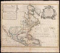
- Creator:
- Homann Erben (Firm)
- Published / Created:
- 1777
- Call Number:
- 755 1777B
- Container / Volume:
- BRBL_00431
- Image Count:
- 1
- Resource Type:
- Maps, Atlases & Globes
- Found in:
- Beinecke Rare Book and Manuscript Library > America Septentrionalis a Domino d'Anville in Galliis edita nunc in Anglia : coloniis in interiorem Virginiam deductis nec non Fluvii Ohio cursu aucta notisque geographicis et historicis illustrata et ad bellum praesentis temporis accomodata / sumptibus Homannianorum Heredum.
- Creator:
- L'Isle, Guillaume de, 1675-1726, cartographer.
- Published / Created:
- [1718]
- Call Number:
- BrSides Double Folio 2019 105
- Image Count:
- 1
- Resource Type:
- Maps, Atlases & Globes
- Found in:
- Beinecke Rare Book and Manuscript Library > America septentrionalis : concinnata juxta observationes D[omi]n[o] n[ostro] Academiae Regalis Scientiarum et nonnullorum aliorum, et juxta annotationes recentissimas / par G. De L'Isle, geographum.
- Creator:
- Speed, John, 1552?-1629.
- Published / Created:
- [1676?]
- Call Number:
- 70 1676
- Container / Volume:
- BRBL_00354
- Image Count:
- 2
- Resource Type:
- Maps, Atlases & Globes
- Found in:
- Beinecke Rare Book and Manuscript Library > America with those known parts in that unknowne worlde both people and manner of buildings / Discribed and inlarged by I.S. Ano 1626 ; Abraham Goos ... sculpsit.
- Published / Created:
- [between 1743-1747?]
- Call Number:
- BrSides Folio 2017 20
- Image Count:
- 1
- Resource Type:
- Maps, Atlases & Globes
- Found in:
- Beinecke Rare Book and Manuscript Library > An accurate map of Kalbar River (commonly called Kalabar or Rio Real) and adjacent coast drawn on ye spot by several pilots, 1699 / G. Child, sculpt.
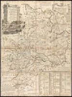
- Creator:
- Bowen, Emanuel, 1693 or 1694-1767, creator.
- Published / Created:
- [1749]
- Call Number:
- 2016 1346
- Image Count:
- 1
- Resource Type:
- Maps, Atlases & Globes
- Found in:
- Beinecke Rare Book and Manuscript Library > An accurate map of the county of Huntingdon divided into its hundreds : drawn from surveys and illustrated with various additional improvements ; also historical extracts relating to its trade, manufactures, natural history &c. not extant in any other map
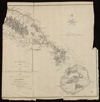
- Published / Created:
- [1782]
- Call Number:
- BrSides Folio 2017 24
- Image Count:
- 1
- Resource Type:
- Maps, Atlases & Globes
- Found in:
- Beinecke Rare Book and Manuscript Library > An accurate map of the islands of St. Christophers and Nevis in the West Indies / by an officer ; with the position of the English and French fleets, February 7th, 1782 ; J. Cary, sc.
- Published / Created:
- [1826]
- Call Number:
- BrSides Folio 2017 31
- Image Count:
- 1
- Resource Type:
- Maps, Atlases & Globes
- Found in:
- Beinecke Rare Book and Manuscript Library > Anahuac o Imperio Megicano : con los Reinos de Acolhuacan y de Michuacan &c., como existan en el año de 1521, para servir de illustracion a la historia antigua de Megico / gravado por Neeles 352 Strand Londres.
- Creator:
- Schenk, Peter, 1660-1718 or 1719.
- Published / Created:
- ca. 1700?]
- Call Number:
- 1973 Folio 18
- Image Count:
- 1
- Resource Type:
- Maps, Atlases & Globes
- Found in:
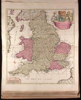
- Beinecke Rare Book and Manuscript Library > Anglia in septem Anglo-Saxonum regna omnesque hodiernas regiones ordine distincta [cartographic material] / ededit Petrus Schenk.
- Creator:
- Valck, G. (Gerard), 1651 or 1652-1726.
- Published / Created:
- ca. 1702?]
- Call Number:
- 1973 Folio 18
- Image Count:
- 1
- Resource Type:
- Maps, Atlases & Globes
- Found in:
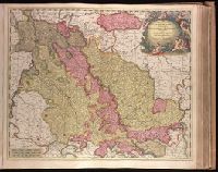
- Beinecke Rare Book and Manuscript Library > Archiepiscopatus Coloniensis, ducatibus Iuliacensi et Montensi intermedius [cartographic material] : queis in septentrionem adjacent Geldria Hispanica, ac comitatus Mursanus / prostant penes Gerardum Valk.
- Creator:
- Robert de Vaugondy, Gilles, 1688-1766.
- Published / Created:
- [1757-1786?]
- Call Number:
- 27 1750
- Container / Volume:
- BRBL_00023A
- Image Count:
- 1
- Resource Type:
- Maps, Atlases & Globes
- Found in:
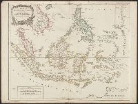
- Beinecke Rare Book and Manuscript Library > Archipel des Indes Orientales : qui comprend les Isles de la Sonde, Moluques et Philippines / tirʹees des Cartes du Neptune Oriental par le Sr. Robert ; Guill. Delahaye sculp.