
You Searched For
« Previous
| 1 - 10 of 14 |
Next »
Search Results


- Call Number:
- 1973 Folio 116
- Collection Title:
- The English pilot: describing the West-India navigation, from Hudson's-Bay to the river Amazones
- Image Count:
- 1
- Description:
- Imperfect: mutilated with some loss of image.
- Subject (Geographic):
- Africa, West --Maps --Early works to 1800, Atlantic Ocean --Maps --Early works to 1800, New England --Maps --Early works to 1800, Newfoundland and Labrador --Maps --Early works to 1800, Portugal --Maps --Early works to 1800, South America --Maps --Early works to 1800, and West Indies --Maps --Early works to 1800
- Subject (Topic):
- Navigation --Early works to 1800, Pilot guides --Atlantic Coast (U.S.) --Early works to 1800, and Pilot guides --Caribbean Area --Early works to 1800
- Collection Created:
- London :
- Found in:
- Beinecke Rare Book and Manuscript Library > A general chart of the western ocean

- Call Number:
- 1974 Folio 72
- Collection Title:
- The English pilot: describing the West-India navigation, from Hudson's-Bay to the river Amazones
- Image Count:
- 2
- Description:
- Mathematical notations on one verso.
- Subject (Geographic):
- Africa, West --Maps --Early works to 1800, Atlantic Coast (North America) --Maps --Early works to 1800, Atlantic Ocean --Maps --Early works to 1800, Newfoundland and Labrador --Maps --Early works to 1800, South America --Maps --Early works to 1800, and West Indies --Maps --Early works to 1800
- Subject (Topic):
- Navigation --Early works to 1800, Pilot guides --Atlantic Coast (U.S.) --Early works to 1800, and Pilot guides --Caribbean Area --Early works to 1800
- Collection Created:
- London : Printed for W. and J. Mount, T. Page and son, on Tower-Hill, MDCCLX [1760]
- Found in:
- Beinecke Rare Book and Manuscript Library > A generall chart of the western ocean

- Call Number:
- 1974 Folio 72
- Collection Title:
- The English pilot: describing the West-India navigation, from Hudson's-Bay to the river Amazones
- Image Count:
- 1
- Subject (Geographic):
- Africa --Maps --Early works to 1800, Antarctic Ocean --Maps, Atlantic Ocean --Maps --Early works to 1800, Europe --Maps --Early works to 1800, North America --Maps --Early works to 1800, and South America --Maps --Early works to 1800
- Subject (Topic):
- Navigation --Early works to 1800, Pilot guides --Atlantic Coast (U.S.) --Early works to 1800, and Pilot guides --Caribbean Area --Early works to 1800
- Collection Created:
- London : Printed for W. and J. Mount, T. Page and son, on Tower-Hill, MDCCLX [1760]
- Found in:
- Beinecke Rare Book and Manuscript Library > A new and correct chart of the western and southern oceans

- Call Number:
- 1974 Folio 72
- Collection Title:
- The English pilot: describing the West-India navigation, from Hudson's-Bay to the river Amazones
- Image Count:
- 1
- Subject (Geographic):
- Africa --Maps --Early works to 1800, Atlantic Ocean --Maps --Early works to 1800, Central America --Maps --Early works to 1800, Great Britain --Maps --Early works to 1800, Newfoundland and Labrador --Maps --Early works to 1800, North America --Maps --Early works to 1800, South America --Maps --Early works to 1800, Spain --Maps --Early works to 1800, and West Indies --Maps --Early works to 1800
- Subject (Topic):
- Navigation --Early works to 1800, Pilot guides --Atlantic Coast (U.S.) --Early works to 1800, and Pilot guides --Caribbean Area --Early works to 1800
- Collection Created:
- London : Printed for W. and J. Mount, T. Page and son, on Tower-Hill, MDCCLX [1760]
- Found in:
- Beinecke Rare Book and Manuscript Library > A new generall chart for the West Indies

- Call Number:
- 1973 Folio 116
- Collection Title:
- The English pilot: describing the West-India navigation, from Hudson's-Bay to the river Amazones
- Image Count:
- 1
- Subject (Geographic):
- Africa --Maps --Early works to 1800, Atlantic Ocean --Maps --Early works to 1800, Central America --Maps --Early works to 1800, Great Britain --Maps --Early works to 1800, Newfoundland and Labrador --Maps --Early works to 1800, North America --Maps --Early works to 1800, South America --Maps --Early works to 1800, Spain --Maps --Early works to 1800, and West Indies --Maps --Early works to 1800
- Subject (Topic):
- Navigation --Early works to 1800, Pilot guides --Atlantic Coast (U.S.) --Early works to 1800, and Pilot guides --Caribbean Area --Early works to 1800
- Collection Created:
- London :
- Found in:
- Beinecke Rare Book and Manuscript Library > A new generall chart for the West Indies

- Call Number:
- 1973 Folio 114
- Collection Title:
- The English pilot: describing the West-India navigation, from Hudson's-Bay to the river Amazones
- Image Count:
- 2
- Resource Type:
- Maps, Atlases & Globes
- Subject (Geographic):
- Africa --Maps --Early works to 1800, Atlantic Ocean --Maps --Early works to 1800, Central America --Maps --Early works to 1800, Great Britain --Maps --Early works to 1800, Newfoundland and Labrador --Maps --Early works to 1800, North America --Maps --Early works to 1800, South America --Maps --Early works to 1800, Spain --Maps --Early works to 1800, and West Indies --Maps --Early works to 1800
- Subject (Topic):
- Navigation --Early works to 1800, Pilot guides --Atlantic Coast (U.S.) --Early works to 1800, and Pilot guides --Caribbean Area --Early works to 1800
- Collection Created:
- London : Printed for W. and J. Mount, T. Page and son, on Tower-Hill, MDCCLIX [1759]
- Found in:
- Beinecke Rare Book and Manuscript Library > A new generall chart for the West Indies
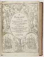
- Creator:
- Bourne, William, d. 1583
Hood, Thomas, fl. 1582-1598 - Published / Created:
- 1601
- Call Number:
- Taylor 146
- Image Count:
- 108
- Description:
- Bound with the author’s A booke called the treasure for traueilers. London, 1578. and Imperfect: some pages mutilated.
- Publisher:
- Printed by T. Wight
- Subject (Topic):
- Navigation --Early works to 1800 and Navigation --Tables
- Found in:
- Beinecke Rare Book and Manuscript Library > A regiment for the sea. Contayning very necessarie matters for all sorts of men and trauailers: Whereunto is added an hydrographicall discourse touching the fiue seuerall passages into Cattay. Written by William Borne. Newly corrected and amended by Tho. Hood, D. in physicke, who hath added a new regiment for the yeare 1600, and three yeares following, and a table of declination. Whereunto is also adioyned The mariners guide, with a perfect sea carde by the said Thomas Hood
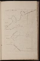
- Call Number:
- 1973 Folio 116
- Collection Title:
- The English pilot: describing the West-India navigation, from Hudson's-Bay to the river Amazones
- Image Count:
- 1
- Subject (Geographic):
- Atlantic Ocean --Maps --Early works to 1800 and Newfoundland and Labrador --Maps --Early works to 1800
- Subject (Topic):
- Navigation --Early works to 1800, Pilot guides --Atlantic Coast (U.S.) --Early works to 1800, and Pilot guides --Caribbean Area --Early works to 1800
- Collection Created:
- London :
- Found in:
- Beinecke Rare Book and Manuscript Library > Cattalina Harbor
10.
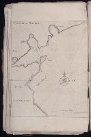
- Call Number:
- 1973 Folio 76
- Collection Title:
- The English pilot: describing the sea-coasts, capes, head-lands, rivers, bays, roads, havens
- Image Count:
- 1
- Description:
- Most maps numbered in pencil on verso, some on recto.
- Subject (Geographic):
- Atlantic Ocean --Maps --Early works to 1800 and Newfoundland and Labrador --Maps --Early works to 1800
- Subject (Topic):
- Navigation --Early works to 1800, Pilot guides --Atlantic Coast (U.S.) --Early works to 1800, and Pilot guides --Caribbean Area --Early works to 1800
- Collection Created:
- London : Printed for John Thornton, at the sign of the England, Scotland, and Ireland, in the Minories, and Richard Mount, at the Postern on Tower-Hill, 1698London : Printed for John Thornton, at the sign of the England, Scotland, and Ireland, in the Minories, and Richard Mount, at the Postern on Tower-Hill, 1698
- Found in:
- Beinecke Rare Book and Manuscript Library > Cattalina Harbor