Search
You Searched For
Search Results
- Creator:
- Encyclopaedia Britannica, inc
Matthews-Northrup Works
- Published / Created:
- 1918?]
- Call Number:
- 11hc 1917R
- Container / Volume:
- BRBL_00010E
- Image Count:
- 1
- Resource Type:
- Maps, Atlases & Globes
- Found in:
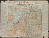
- Beinecke Rare Book and Manuscript Library > A geographical and historical guide to the world's wars, 4000 B.C. to 1918 [cartographic material] : No. 1, north-western Europe, showing the "Western Front" / engraved and printed at the Matthews-Northrup Works, Buffalo, N.Y.
- Creator:
- Encyclopaedia Britannica, inc
Matthews-Northrup Works
- Published / Created:
- 1918?]
- Call Number:
- 11hc 1918J-2
- Container / Volume:
- BRBL_00010F
- Image Count:
- 1
- Resource Type:
- Maps, Atlases & Globes
- Found in:
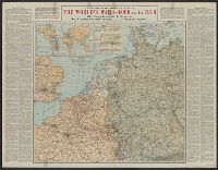
- Beinecke Rare Book and Manuscript Library > A geographical and historical guide to the world's wars, 4000 B.C. to 1918 [cartographic material] : No. 1, north-western Europe, showing the "Western Front" / engraved and printed at the Matthews-Northrup Works, Buffalo, N.Y.
- Published / Created:
- 27 Novr. 1775.
- Call Number:
- 764 B65 1775G
- Container / Volume:
- BRBL_00454
- Image Count:
- 1
- Resource Type:
- Maps, Atlases & Globes
- Found in:
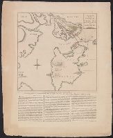
- Beinecke Rare Book and Manuscript Library > A plan of the battle on Bunkers Hill : fought on the 17th of June 1775, by an officer on the spot.
- Creator:
- De Costa, J
- Published / Created:
- July 29th, 1775.
- Call Number:
- 764 B65 1775
- Container / Volume:
- BRBL_00454
- Image Count:
- 1
- Resource Type:
- Maps, Atlases & Globes
- Found in:
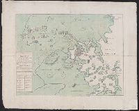
- Beinecke Rare Book and Manuscript Library > A plan of the town and harbour of Boston and the country adjacent, with the road from Boston to Concord : shewing the place of the late engagement between the King's troops & the provincials, together with the several encampments of both armies in & about
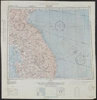
- Creator:
- United States. Army Map Service
- Published / Created:
- 1944
- Call Number:
- 50 1945O
- Container / Volume:
- BRBL_00273
- Image Count:
- 2
- Resource Type:
- Maps, Atlases & Globes
- Found in:
- Beinecke Rare Book and Manuscript Library > AAF cloth chart [cartographic material] : Eastern Asia / Army Map Service.
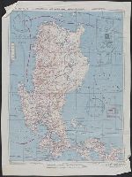
- Creator:
- United States. Army Air Forces
- Published / Created:
- 1944
- Call Number:
- 50 1945B
- Container / Volume:
- BRBL_00273
- Image Count:
- 2
- Resource Type:
- Maps, Atlases & Globes
- Found in:
- Beinecke Rare Book and Manuscript Library > AAF cloth chart [cartographic material] : no. C40, Luzon Island / Army Map Service U.S. Army.
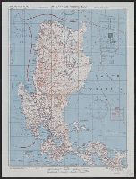
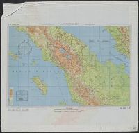
- Published / Created:
- 1945
- Call Number:
- 50 1945A
- Container / Volume:
- BRBL_00273
- Image Count:
- 2
- Resource Type:
- Maps, Atlases & Globes
- Found in:
- Beinecke Rare Book and Manuscript Library > AAF cloth chart. C-800, We Island / Prepared at the direction of the Commanding General, Army Air Forces, by the Aeronautical Chart Service, Washington, D.C., from existing Aeronautical Charts, March 1945, Base No. 1.
- Creator:
- U.S. Lake Survey
- Published / Created:
- 1945
- Call Number:
- 50 1945
- Container / Volume:
- BRBL_00273
- Image Count:
- 2
- Resource Type:
- Maps, Atlases & Globes
- Found in:
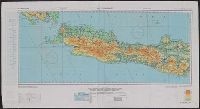
- Beinecke Rare Book and Manuscript Library > AAF cloth chart. No. C-48 West Java / reproduced under the direction of the Commanding General, Army Air Forces for the Aeronautical Chart Service by the Army Map Service, Washington D.C. ; copied by Lake Survey Branch, A.M.S., Detroit, Michigan, July 194
- Creator:
- United States. Army Map Service
- Published / Created:
- 1944
- Call Number:
- 56gms 1944
- Container / Volume:
- BRBL_00299
- Image Count:
- 2
- Resource Type:
- Maps, Atlases & Globes
- Found in:
- Beinecke Rare Book and Manuscript Library > AAF cloth map [cartographic material] / prepared under the direction of the Commanding General, Army Air Forces, by the Aeronautical Chart Service.