Search
You Searched For
Search Results
- Published / Created:
- 1861
- Call Number:
- 899 1861
- Container / Volume:
- BRBL_00660
- Image Count:
- 5
- Resource Type:
- Maps, Atlases & Globes
- Found in:
- Beinecke Rare Book and Manuscript Library > Interoceanic ship canal via the Atrato and Truando Rivers.
- Creator:
- Oficina de Límites (Chile)
- Published / Created:
- 1905
- Call Number:
- 9617 1905
- Container / Volume:
- BRBL_00676
- Image Count:
- 1
- Resource Type:
- Maps, Atlases & Globes
- Found in:
- Beinecke Rare Book and Manuscript Library > Mapa jeografico de la Puna de Atacama [cartographic material].
- Published / Created:
- 1908
- Call Number:
- 98 1908
- Container / Volume:
- BRBL_00679
- Image Count:
- 1
- Resource Type:
- Maps, Atlases & Globes
- Found in:
- Beinecke Rare Book and Manuscript Library > Mapa General de la Republica de Bolivia / por Luis Garcia Meza.
- Creator:
- White, James, 1863-1928
- Published / Created:
- 1904
- Call Number:
- 73cbf 1904
- Container / Volume:
- BRBL_00375A
- Image Count:
- 1
- Resource Type:
- Maps, Atlases & Globes
- Found in:
- Beinecke Rare Book and Manuscript Library > Relief map of the Dominion of Canada / James White, geographer.
- Published / Created:
- 1905?]
- Call Number:
- 754cbf 1910
- Container / Volume:
- BRBL_00417
- Image Count:
- 1
- Resource Type:
- Maps, Atlases & Globes
- Found in:
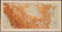
- Beinecke Rare Book and Manuscript Library > Relief map of the southern Appalachian region : showing the distribution of the mountains.
- Creator:
- Gannett, Henry, 1846-1914
- Published / Created:
- [1904]
- Call Number:
- 754cbf 1904
- Container / Volume:
- BRBL_00417
- Image Count:
- 1
- Resource Type:
- Maps, Atlases & Globes
- Found in:
- Beinecke Rare Book and Manuscript Library > United States contour map / U.S. Geological Survey ; compiled by Henry Gannett.
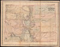
- Creator:
- Ebert, Frederick J
- Published / Created:
- 1862
- Call Number:
- 834gbc 1862
- Image Count:
- 1
- Resource Type:
- Maps, Atlases & Globes
- Found in:
- Beinecke Rare Book and Manuscript Library > Map of Colorado Territory embracing the Central Gold Region [cartographic material] / drawn by Frederick J. Ebert ; under direction of the Governor Wm. Gilpin.
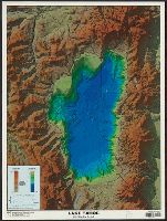
- Creator:
- Johnson, Gary L. (Gary Lee), 1947-
- Published / Created:
- [2000?]
- Call Number:
- 844 L1492 2000
- Container / Volume:
- BRBL_00605
- Image Count:
- 1
- Resource Type:
- Maps, Atlases & Globes
- Found in:
- Beinecke Rare Book and Manuscript Library > Lake Tahoe : 3-D shaded relief / cartography by Gary Johnson and Kris Ann Pizarro.
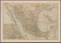
- Creator:
- Matthews-Northrup Works
- Published / Created:
- c1916.
- Call Number:
- 88 1916
- Container / Volume:
- BRBL_00646
- Image Count:
- 1
- Resource Type:
- Maps, Atlases & Globes
- Found in:
- Beinecke Rare Book and Manuscript Library > Map of Mexico / prepared especially for the National Geographic magazine, Gilbert H. Grosvenor, editor, by the Matthews-Northrup Works, Buffalo N.Y.
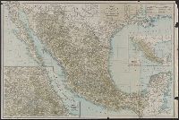