Search
You Searched For
Search Results
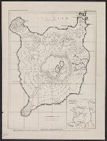
- Creator:
- Coleman, S. B
- Published / Created:
- 1910]
- Call Number:
- 28 T11 1909
- Container / Volume:
- BRBL_00024
- Image Count:
- 1
- Resource Type:
- Maps, Atlases & Globes
- Found in:
- Beinecke Rare Book and Manuscript Library > Topographic map of Taal Island showing Taal volcano / S.B. Coleman, surveyor.
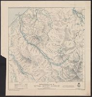
- Creator:
- Crawford, R. J
- Published / Created:
- 1907
- Call Number:
- 267 T64 1907
- Container / Volume:
- BRBL_00023
- Image Count:
- 1
- Resource Type:
- Maps, Atlases & Globes
- Found in:
- Beinecke Rare Book and Manuscript Library > Topographical map of Totara survey district / compiled and drawn by R. J. Crawford.
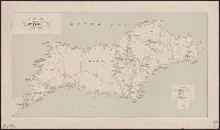
- Creator:
- Topografische Inrichting (Jakarta, Indonesia)
- Published / Created:
- 1911
- Call Number:
- 2725 1911
- Container / Volume:
- BRBL_00023B
- Image Count:
- 1
- Resource Type:
- Maps, Atlases & Globes
- Found in:
- Beinecke Rare Book and Manuscript Library > Schetskaart van het eiland Wetar / Topografische Inrichting.
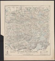
- Creator:
- Harris, G. E
- Published / Created:
- 1908
- Call Number:
- 267 W58 1908
- Container / Volume:
- BRBL_00023
- Image Count:
- 1
- Resource Type:
- Maps, Atlases & Globes
- Found in:
- Beinecke Rare Book and Manuscript Library > Topographical map of Whitcombe Pass survey district and portions of Poerua and Butler s.d.'s. / compiled and drawn by G. E. Harris.
- Creator:
- Davies, Henry Rodolph, 1865-
- Published / Created:
- 1908
- Call Number:
- 5631 1908
- Container / Volume:
- BRBL_00299
- Image Count:
- 1
- Resource Type:
- Maps, Atlases & Globes
- Found in:
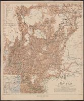
- Beinecke Rare Book and Manuscript Library > Map of Yün-nan / compiled by Major H.R. Davies.
- Creator:
- Davies, Henry Rodolph, 1865-
- Published / Created:
- 1908
- Call Number:
- 5631 1908
- Container / Volume:
- BRBL_00299
- Image Count:
- 1
- Resource Type:
- Maps, Atlases & Globes
- Found in:
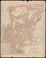
- Beinecke Rare Book and Manuscript Library > Map of Yün-nan / compiled by Major H.R. Davies.
- Creator:
- Geological Survey (U.S.)
- Published / Created:
- 1909
- Call Number:
- 848 1909
- Container / Volume:
- BRBL_00630
- Image Count:
- 1
- Resource Type:
- Maps, Atlases & Globes
- Found in:
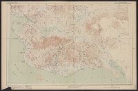
- Beinecke Rare Book and Manuscript Library > Map of Alaska / compiled chiefly from maps of the U.S. Geological Survey ... Alfred H. Brooks, geologist in charge, Division of Alaskan Mineral Resources.
- Creator:
- Geological Survey (U.S.)
- Published / Created:
- 1909
- Call Number:
- 848 C26 1909
- Container / Volume:
- BRBL_00632
- Image Count:
- 1
- Resource Type:
- Maps, Atlases & Globes
- Found in:
- Beinecke Rare Book and Manuscript Library > Alaska, Casadepaga quadrangle / U.S. Geological Survey.
- Creator:
- Geological Survey (U.S.)
- Published / Created:
- 1907
- Call Number:
- 848 Se87 1907A
- Container / Volume:
- BRBL_00634
- Image Count:
- 1
- Resource Type:
- Maps, Atlases & Globes
- Found in:
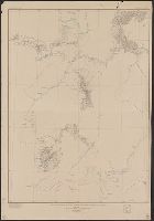
- Beinecke Rare Book and Manuscript Library > Reconnaissance map, southern part of Seward Peninsula, Alaska / topography by E.C. Barnard, D.L. Reaburn, J.G. Hefty ... [et al.].
- Creator:
- Geological Survey (U.S.)
- Published / Created:
- 1921
- Call Number:
- 848 K96 1921
- Container / Volume:
- BRBL_00633
- Image Count:
- 1
- Resource Type:
- Maps, Atlases & Globes
- Found in:
- Beinecke Rare Book and Manuscript Library > Reconnaissance map of the Lower Kuskokwim region, Alaska / U.S. Geological Survey ; Alfred H. Brooks, Geologist in charge of division, topography by A.G. Maddren, R.H. Sargent and W.S. Post.