Skip to search
Skip to main content
Skip to first result
Search
You Searched For
Genre
World maps.
Search Results
Creator:
Published / Created:
1627]
Call Number:
11 1626
Container / Volume:
BRBL_00003
Image Count:
2
Resource Type:
Maps, Atlases & Globes
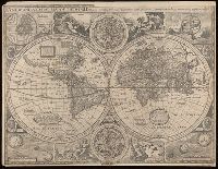
Alternative Title:
New and accurat map of the world
Description:
"Are to be sold in Pops- head Alle by Geor. Humble".
Publisher:
George Humble,
Subject (Name):
Humble, George, -1640. and Speed, John, 1552?-1629. Prospect of the most famous parts of the world.
Subject (Topic):
World maps--Early works to 1800.
Found in:
Beinecke Rare Book and Manuscript Library > A new and accvrat map of the world : drawne according to ye truest descriptions, latest discoueries & best obseruations yt have beene made by English or strangers, 1626.
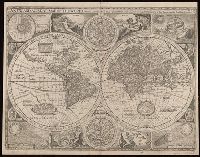
Creator:
Published / Created:
[1676]
Call Number:
11 1651A
Container / Volume:
BRBL_00003
Image Count:
1
Resource Type:
Maps, Atlases & Globes
Alternative Title:
A new and accurat map of the world
Description:
"Are to be sold by Tho: Bassett in Fleet Street and Ric: Chiswell in St. Pauls Church yard"
Publisher:
Sold by Tho. Bassett and Ric. Chiswell,
Subject (Name):
Bassett, Thomas, bookseller., Chiswell, Richard., and Speed, John, 1552?-1629. Prospect of the most famous parts of the world.
Subject (Topic):
World maps--Early works to 1800.
Found in:
Beinecke Rare Book and Manuscript Library > A new and accvrat map of the world : drawne according to ye truest descriptions, latest discoveries & best observations yt have beene made by English or strangers, 1651.
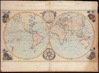
Creator:
Published / Created:
May 1780.
Call Number:
11 1780B
Image Count:
1
Resource Type:
Maps, Atlases & Globes
Description:
Hand coloured double hemispheric map of the world (Western hemisphere, or, the New World, and Eastern hemisphere, or, the Old World), with four decorative hand coloured vignettes representing Europe, Asia, America, and Africa.
Publisher:
Printed for the Proprietor, Carington Bowles, No. 69, in St. Paul's Churchyard,
Subject (Topic):
World maps--Early works to 1800.
Found in:
Beinecke Rare Book and Manuscript Library > Bowles's new pocket map of the world : laid down from the latest observations and comprehending the new discoveries to the present time, particularly those lately made in the southern seas, by Byron, Wallis, Cook, Bougainville, and others.
Creator:
Published / Created:
[1569]
Call Number:
11 1550
Image Count:
2
Resource Type:
Maps, Atlases & Globes
Alternative Title:
Erst general oder gemeine tafeln
Description:
"DK," the initials of woodcutter David Kandel, appear in lower left-hand corner.
Publisher:
[Henricpetrina],
Subject (Name):
Kandel, David, -1587
Subject (Topic):
World maps--Early works to 1800.
Found in:
Beinecke Rare Book and Manuscript Library > Das erst general, inhaltend die beschreibung und den circkel des gantzen erdtreichs und moeres [cartographic material] / Münster, cosmographer.
Creator:
Published / Created:
[1607]
Call Number:
11 1607
Container / Volume:
BRBL_00003
Image Count:
2
Resource Type:
Maps, Atlases & Globes
Description:
Imperfect: two small holes at upper right corner where oxidized by pigment. Label on verso with manuscript number "550/149." Cross collection no. 6. Mounted on paper.
Publisher:
[Jodocus Hondius],
Subject (Topic):
World maps--Early works to 1800.
Found in:
Beinecke Rare Book and Manuscript Library > Designatio orbis Christiani.
Creator:
Published / Created:
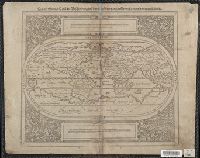
1588?]
Call Number:
11 1588
Image Count:
2
Resource Type:
Maps, Atlases & Globes
Description:
Imperfect: torn along middle fold, with some loss of text. Cross collection no. 3.
Publisher:
Sebastian Petri,
Subject (Name):
Henricpetri, Sebastian, 1547-1627.
Subject (Topic):
World maps--Early works to 1800.
Found in:
Beinecke Rare Book and Manuscript Library > Die erst general Tafel die Beschreibung und den Circkel des gantzen Erdtrichs und Meeres innhaltende.
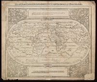
Creator:
Published / Created:
1588?]
Call Number:
11 1588
Image Count:
2
Resource Type:
Maps, Atlases & Globes
Description:
Imperfect: lower right corner mutilated, with some loss of text; worm holes, with some loss of text. Cross collection no. 12.
Publisher:
Sebastian Petri,
Subject (Name):
Henricpetri, Sebastian, 1547-1627.
Subject (Topic):
World maps--Early works to 1800.
Found in:
Beinecke Rare Book and Manuscript Library > Die erst general Tafel die Beschreibung und den Circkel des gantzen Erdtrichs und Meeres innhaltende.
Creator:
Published / Created:
[1572?]
Call Number:
BrSides Box 2017 2
Image Count:
1
Resource Type:
Maps, Atlases & Globes
Alternative Title:
Carta da navigare
Description:
[Page] 198; includes text.
Publisher:
[publisher not identified],
Subject (Name):
Porcacchi, Thomaso, approximately 1530-1585?
Subject (Topic):
World maps--Early works to 1800.
Found in:
Beinecke Rare Book and Manuscript Library > Discorso intorno alla carta da navigare.
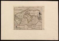
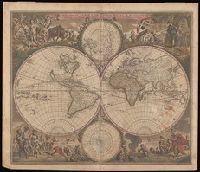
Creator:
Call Number:
BrSides Double Folio 2019 116
Image Count:
1
Resource Type:
Maps, Atlases & Globes
Alternative Title:
Nova orbis tabula in lucem edita
Description:
Allegorical vignettes of the four seasons.
Subject (Geographic):
World--Maps--Early works to 1800.
Subject (Topic):
World maps--Early works to 1800.
Found in:
Beinecke Rare Book and Manuscript Library > Nova orbis tabvla in lvcem edita / a. F. de Wit.
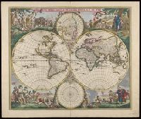
Creator:
Call Number:
11 1670A
Image Count:
1
Resource Type:
Maps, Atlases & Globes
Alternative Title:
Nova orbis tabula in lucem edita
Description:
Allegorical vignettes of the four seasons.
Subject (Geographic):
World--Maps--Early works to 1800.
Subject (Topic):
World maps--Early works to 1800.
Found in:
Beinecke Rare Book and Manuscript Library > Nova orbis tabvla in lvcem edita / a. F. de Wit.