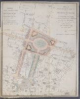
This plan shows the intention to remove Bethlem ('Bedlam") Hospital and replace it with the 'London Amphitheatre' which would comprise at least 60 houses with gardens, stables and coach-houses suitable for 'Opulent Citizens'. This complex will be linked directly to the Royal Exchange via a 80-ft wide new street
Description:
Colored for reference with an explanation note at upper left. Following imprint beneath map: Price one shilling., Shows George Dance's scheme for the reconstruction of streets from the Bank north to Finsbury Square. The designs were only partly carried out. The 'London Amphitheatre' on the site of Bethlehem Hospital was built as Finsbury Circus in about 1812., Sheet trimmed to 37 x 30.8 cm, resulting in partial loss of imprint and price statement beneath map., and Tipped in opposite page 396 in volume 1 of an extra-illustrated copy of: Malcolm, J.P. Londinium redivivum, or, An antient history and modern description of London.
Publisher:
Engrav'd & publish'd by John Luffman, No. 28, Little Bell Alley, Coleman Street
Subject (Geographic):
England, London, City of London (England), London (England), City of London., and London.
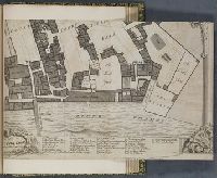
Survey and ground plot of the Royal Palace of White Hall
Description:
Map of the Palace of Whitehall, showing the various rooms, courts, gardens, wharves, barracks and the park beyond, the river to the south. An elegant border formed of pillars with scrolling capitals and two keys to the map. Inset maps to the upper left and right of Charing Cross and Whitehall respectively. A further key below and a descriptive text on a book to the upper left., The title on a banner above between three armorials., A scale on the pillar to the left., Imperfect; only lower right quadrant is present (sheet 22.5 x 34.2 cm), with the rest of the map trimmed away., Folded to 22.5 x 17.4 cm; mounted to 27.1 x 21.3 cm., and Mounted after page 278 in volume 4 part 1 of an extra-illustrated copy of: Malcolm, J.P. Londinium redivivum, or, An antient history and modern description of London.
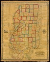
State of Mississippi, with a large portion of Louisiana and Alabama
Description:
BEIN Roll Map 420: Mounted on linen. Printed label on verso: Rhode Island Historical Society., Relief shown by shading., "Scale 6 miles to the inch.", Prime meridian: Washington, D.C. Coordinates converted by cataloger to express longitude as measured from the Greenwich meridian., Includes list of land districts and legend. Some ancillary maps include indexes., Ornamental border., and "Entered according to Act of Congress in the year 1839 by John La Tourrette in the Clerk's Office of the District Court of the Southern District of Alabama."
Publisher:
Compiled & published by John La Tourrette and Engraved by S. Stiles, Sherman & Smith
Subject (Geographic):
Mississippi, Alabama, Louisiana, Alabama., Louisiana., and Mississippi.
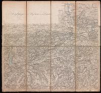
Relief shown by hachures., Sheets comprised of multiple panels with extensions; sheets not quadrilinear., At foot of some sheets: C. Stein, scrip., and Some sheets include small numbers identifying numbered component sheets.
Publisher:
Kaiserlich Königlich Österreichischen General Quartiermeister Stabe
Subject (Geographic):
Tyrol (Austria), Vorarlberg (Austria), and Liechtenstein
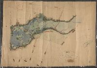
Imperfect: mutilated. Mounted on linen. Manuscript note on verso (partially trimmed): Map of old P[?]; D.G. Mitchell., Date of production precedes statement of responsibility., Oriented with north towards right., Relief shown by hachures., "Scale: 140 ft. to inch.", Coordinates not present on map and are approximated., Includes names of ownership., and Includes inset map of surrounding area in lower right corner.
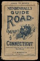
BEIN 766 1909: Original wrappers. Illegible inscription on front wrapper., Also has a 48 page Route Guide to Massachusetts, Connecticut & R.I. This company also published maps of the west in the 1870's, under the name Edward Mendenhall. Covers are brown card board 18.5x11.5 printed with an illustration of three people in an automobile and the title "Mendenhall's Guide And Road-Map of Connecticut With District Maps. C.S. Mendenhall, Map Publisher, Cincinnati. Price 75 Cts.", and Coordinates not present on map and are approximated.
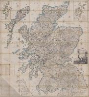
Scotland drawn and engraved from a series of angles and astronomical observations
Description:
Title from cartouche., Engraved throughout., Relief shown by contour lines and pictures., Scale of miles 69 1/2 to a degree., Another imprint: "Published according to Act of Parliament Jan. 1st. 1789 by John Ainslie ... and William Faden ..." at bottom of sheet., Inset maps: "Shetland Islands laid down upon a less scale than the map ... "; "A Map of the Orkney Islands ...", Distance tables and lists of heights of hills and roads from Edinburgh to London., Edinburgh meridian, with note of degrees from Greenwich., Title cartouche shows men fishing and herding cattle, with sheep goats and foliage., Six compass roses., This issue not in Chubb, T. Printed maps in the atlases of Great Britain and Ireland., and Scotland.
Publisher:
Printed and sold by the proprietor Thomas Brown, North Bridge Street, Edinburgh and Publish'd according to Act of Parliament with improvements till 1800 by Thomas Brown ... Edinburgh and William Faden ... London
Subject (Geographic):
Scotland, Orkney (Scotland), Shetland (Scotland), Scotland., Orkney., and Shetland.
Bankoku ichiranzu, Bankoku ichiran zusetsu, and (Explanation of the visualized map of all the countries)
Description:
BEIN 2018 +512: Manuscript annotations in English on margins of map., Cover attached; cover and map title the same., Accompanied by: BANKOKU ICHIRAN ZUSETSU : (Explanation of the visualized map of all the countries) / Koyano Yoshiharu. -- Bunka 7 : (1810). -- 2 v., ill. ; 25.2 x 18 cm., Kôzanrō is a private school of Koyano Yoshiharu., and California shown as an island.
Publisher:
Kôzanrô, (June, 1809)
Subject (Geographic):
Japan and Japan.
Subject (Topic):
World maps, Geography, Study and teaching, and Prints, Japanese