Vervolg op alle de copyen van indagingen, alsmede alle de gedichten op de tegenwoordige tyd toepasselyk
Description:
Includes poetry about, and criminal charges and sentences for homosexuality., No. 2 of 4 titles bound together., and Second part with divisional title page: Vervolg op alle de copyen van indagingen, alsmede alle de gedichten op de tegenwoordige tyd toepasselyk.
Publisher:
s.n.,
Subject (Topic):
Executions and executioners--Netherlands--Early works to 1800, Homosexuality--Law and legislation--Early works to 1800, Homosexuality--Poetry, and LGBTQ resource
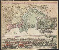
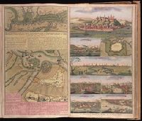
Accurate aftekening hoe de twee Legers geleegen hebben voor Belgrado, ent bomberderen en kanonneeren op malkanderen van den 2 tot den 14 Augustus anno 1717 and Nieuwe accurate kaart van de marse der Keyserlyke armee van Peter Wardien en Futak.
Description:
Backed with paper. Ms. no. in upper right corner [illegible due to trimming]. Sheet measures 53.8 x 62.4 cm. No. 74 of 87 maps bound together., On sheet with 1 other map ("Nieuwe accurate kaart van de marse der Keyserlyke armee van Peter Wardien en Futak ... tot voor Belgrado ... 9 tot den 19 Iuny anno 1717") and 7 bird's-eye views ("Belgrad," "Temeswar" [with map "De Stadt Temeswar"], "Temeswar" [2], "Wardien," "Offen v. Pest," "Sigeth," and "Citta e porto di Constantinopoli")., Relief shown pictorially., and With inset bird's-eye view of Belgrade in upper left corner.
"Cum privil.", Appears in Schenk's Atlas contractus ... [Amsterdam : Peter Schenk, ca. 1700]., Imperfect: Mutilated, with some loss of text. Sheet measures 53.5 x 62 cm. Verso: "19" (?) in ink ms., Insets: Batavorum colon, and Relief shown pictorially.
Publisher:
Peter Schenk?
Subject (Geographic):
East Indies--Maps--Early works to 1800, Netherlands--Maps--Early works to 1800, and New Netherland--Maps--Early works to 1800
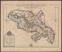
Bar scales given in "Lieues Marines et d'Espagne de 17 1/2 au Degré" and "Lieues Com. de France dont 25 font un Degré.", From Guillaume de L'Isle's Atlas nouveau, contenant toutes les parties du monde. Amsterdam : Chez Jean Cóvens & Corneille Mortier, [1742]., and Prime meridian: Ferro.
Publisher:
Chez Jean Covens et Corneille Mortier, geographes,
Subject (Geographic):
Martinique--Maps--Early works to 1800
Subject (Name):
Buache, Philippe, 1700-1773, Cóvens et Mortier, printer, and L'Isle, Guillaume de, 1675-1726. Atlas nouveau
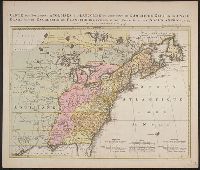
Kaart van de Engelsche en Fransche bezittingen in het vaste land van Noord America. and Possessions angloises & françoises du continet de l'Amérique septentrionale.
Description:
Based on Jean Palairet's Carte des possessions angloises françoises du continent de l'Amérique septentrionale, 1755., Hand colored., LC copy 2 accompanied by Jean Palairet's Beknopte beschr, Prime meridian: London and Île de Fer., and Relief shown pictorially.
Publisher:
Chez R. et J. Ottens, geográphes,
Subject (Geographic):
North America--Maps--Early works to 1800
Subject (Name):
Ottens, J. (Josua), 1704-1765 and Palairet, Jean, 1697-1774. Carte des possessions angloises françoises du continent de l'Amérique septentrionale
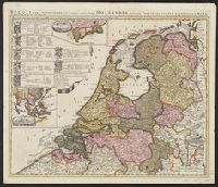
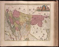
"Cum privil.", "I. Bormeester, eccu.", Bar scales given in "Gemene Duÿtsche Mÿlen 15 in een Graedt" and "Uren gaens de 4 maken 3 Mÿlen"., BEIN 1973 Folio 18: Backed with paper. Ms. no. "41" in upper-right corner. Sheet measures 53.6 x 62.7 cm. No. 40 of 87 maps bound together., Inset: De resterende Eÿlanden van Hollant alhier bÿgevoecht., North oriented to the upper-right., Prime meridian: Ferro., Relief shown pictorially., and Title in Latin; place names in Dutch.