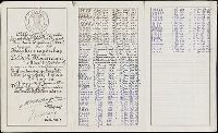
Manuscript perpetual obligation bond, on parchment, issued by a Dutch water board responsible for the upkeep of local dykes. The records of interest paid the bearer are written on the bond through the year 1943; thereafter the interest was recorded on the paper talon which accompanies the bond.
Description:
Gift of the International Center for Finance at the Yale School of Management, 2009., In Dutch., and Paper seal in upper left corner of bond.
Subject (Geographic):
Netherlands--Economic conditions
Subject (Name):
Hoogheemraadschap Lekdijk Bovendams
Subject (Topic):
Bonds--Netherlands and Government securities--Netherlands
Terra Neuf, en de custen van Nieu Engeland, Nieu Nederland, Nieu Andalusia, Guiana en Venezuela
Description:
Covers the Atlantic Ocean west of the Azores and Cape Verde Islands, and the coasts of northeastern North America and northern South Amerca., Fr, In Latin and Dutch., Includes two decorative cartouches and ill., North oriented to left., and With "22" at top right.
Publisher:
Gedruckt by Fredrick de Wit in de Kalverstrae,
Subject (Geographic):
Atlantic Provinces--Maps--Early works to 1800 and North Atlantic Ocean--Maps--Early works to 1800
Subject (Name):
Wit, Frederik de. Orbis Maritimus ofte Zee Atlas
Subject (Topic):
Nautical charts--Atlantic Ocean--Early works to 1800
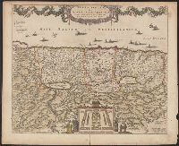
"20" in upper right corner., Along the top of the map is a garland supported by a cherubim; at bottom center, the encapment of the tribes flanked by Moses and Aaron is pictured., Appears in various editions of Wit's Atlas., Relief shown pictorially., and Sheet me
Publisher:
Gedruckt tot Amsterdam by Frederick de Wit in de Calverstraet by den Dam inde Witte Paskaert,
Subject (Geographic):
Palestine--History--To 70 A.D.--Maps and Palestine--Maps--Early works to 1800
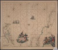
Terra neuf, en de custen van Nieu Vranckryck, Nieu Engeland, Nieu Nederland, Nieu Andalusia, Guiana en Venezuela
Description:
At upper right corner: Fol. 26., Covers the Atlantic Ocean west of, From Renard's Atlas de la navigation et du commerce ... Amsterdam : Chez Louis Renard, 1715., In Latin and Dutch., Includes two decorative cartouches and ill., and Oriented with north to the left.
Publisher:
Gedruckt by L. Renard,
Subject (Geographic):
North Atlantic Ocean--Maps--Early works to 1800
Subject (Name):
Renard, Louis. Atlas de la navigation et du commerce
Subject (Topic):
Nautical charts--North Atlantic Ocean--Early works to 1800
Terra neuf, en de custen van Nieu Vranckryck, Nieu Engeland, Nieu Nederland, Nieu Andalusia, Guiana en Venezuela
Description:
Covers the Atlantic Ocean west of the Azores and Cape Verde Islands, and the coasts of northeastern North America and northern South Amerca., In Latin and Dutch., Includes two decorative cartouches and ill., Ms. "25" in upper right margin., and Oriented with nort
Publisher:
Gedruckt by Fredrick de Wit in de Kalverstraet,
Subject (Geographic):
North Atlantic Ocean--Maps--Early works to 1800
Subject (Topic):
Nautical charts--North Atlantic Ocean--Early works to 1800
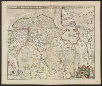
Charts and title pages in English, text in Dutch., Map oriented with North at bottom left., and Volvelle on p. [17].
Publisher:
Jodocus Hondius excudit,
Subject (Geographic):
Europe --Maps --Early works to 1800, Great Britain --Maps --Early works to 1800, Netherlands --Maps --Early works to 1800, and North Sea --Maps --Early works to 1800