Search
You Searched For
Search Results
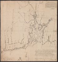
- Published / Created:
- 1741
- Call Number:
- 765 1741
- Container / Volume:
- BRBL_00463
- Image Count:
- 1
- Resource Type:
- Maps, Atlases & Globes
- Found in:
- Beinecke Rare Book and Manuscript Library > An exact Plan of the Sea Coast of the Continent, fron Paucatuck River, Eastwards, to Point Judith, and from thence, Nortwards, to the Town of Providence, ... to Slocums Harbour ... Jas. Helme, Wm. Chandler, Surveyrs. By order of his Matys.
- Published / Created:
- 1776]
- Call Number:
- 766 1776
- Container / Volume:
- BRBL_00690
- Image Count:
- 1
- Resource Type:
- Maps, Atlases & Globes
- Found in:
- Beinecke Rare Book and Manuscript Library > A map of Connecticut and Rhode Island with Long Island Sound, &c.
- Published / Created:
- 1776]
- Call Number:
- 766 1776
- Container / Volume:
- BRBL_00690
- Image Count:
- 1
- Resource Type:
- Maps, Atlases & Globes
- Found in:
- Beinecke Rare Book and Manuscript Library > A map of Connecticut and Rhode Island with Long Island Sound, &c.
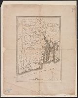
- Published / Created:
- 1796?]
- Call Number:
- 765 1796
- Container / Volume:
- BRBL_00463
- Image Count:
- 1
- Resource Type:
- Maps, Atlases & Globes
- Found in:
- Beinecke Rare Book and Manuscript Library > The state of Rhode Island; compiled from the surveys and observations of Caleb Harris, by Harding Harris.