Search
You Searched For
Search Results
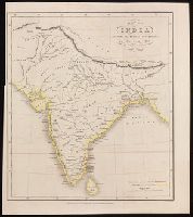
- Creator:
- Danvers, Juland, cartographer
- Published / Created:
- Octr. 17th, 1842.
- Call Number:
- BrSides 2019 77
- Image Count:
- 1
- Resource Type:
- Maps, Atlases & Globes
- Found in:
- Beinecke Rare Book and Manuscript Library > Map of India : shewing the British possessions in the year 1750 / by Juland Danvers ; J. & C. Walker, sculpt.
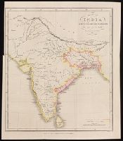
- Creator:
- Danvers, Juland, cartographer
- Published / Created:
- Octr. 17th, 1842.
- Call Number:
- BrSides 2019 76
- Image Count:
- 1
- Resource Type:
- Maps, Atlases & Globes
- Found in:
- Beinecke Rare Book and Manuscript Library > Map of India : shewing the British possessions in the year 1784 / by Juland Danvers ; J. & C. Walker, sculpt.
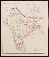
- Creator:
- Danvers, Juland, cartographer
- Published / Created:
- Octr. 17th, 1842.
- Call Number:
- BrSides 2019 75
- Image Count:
- 1
- Resource Type:
- Maps, Atlases & Globes
- Found in:
- Beinecke Rare Book and Manuscript Library > Map of India : shewing the British possessions in the year 1792 / by Juland Danvers ; J. & C. Walker, sculpt.
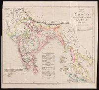
- Creator:
- Danvers, Juland, cartographer.
- Published / Created:
- Decr. 1st, 1842.
- Call Number:
- BrSides 2019 78
- Image Count:
- 1
- Resource Type:
- Maps, Atlases & Globes
- Found in:
- Beinecke Rare Book and Manuscript Library > Map of India : shewing the British possessions in the year 1842 / by Juland Danvers ; J. & C. Walker, sculpt.
- Creator:
- Society for the Diffusion of Useful Knowledge (Great Britain), cartographer
- Published / Created:
- 1834
- Call Number:
- 642 1834
- Image Count:
- 2
- Resource Type:
- Maps, Atlases & Globes
- Found in:
- Beinecke Rare Book and Manuscript Library > South Africa [cartographic material] : compiled from the M.S. maps in the Colonial Office, Captn. Owen's survey &c. / published under the Superintendence of the Society for the Diffusion of Useful Knowledge by Baldwin & Cradock ; J. & C. Walker, sculpt.
- Creator:
- Great Britain. Hydrographic Department, cartographer
- Published / Created:
- March 23rd 1846.
- Call Number:
- BrSides 2019 97
- Image Count:
- 1
- Resource Type:
- Maps, Atlases & Globes
- Found in:
- Beinecke Rare Book and Manuscript Library > South Australia, St. Vincent Gulf, Port Adelaide and Holdfast Bay / surveyed by Commr. Stokes, H.M.S. Beagle, 1841 ; J. & C. Walker, sculpt.
- Creator:
- Vidal, A. T. E. (Alexander Thomas Emeric), 1792-1863, author
- Call Number:
- 655 1827
- Container / Volume:
- BRBL_00345
- Image Count:
- 1
- Resource Type:
- Maps, Atlases & Globes
- Found in:
- Beinecke Rare Book and Manuscript Library > The west coast of Africa : from latitude 1°, 35ʹ N. to 5°, 50ʹ N. and from longitude 4, 55 E. to 10, 45 E. / by Captn. A.T.E. Vidal & the officers of H.M. Sloop Barracouta under the orders of Captn. W.F.W. Owen, 1826 ; J. & C. Walker, sculpt.