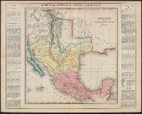
Complete historical, chronological and geographical American atlas. and Mexico and internal provinces
Description:
"Mexico, No. 38.", Appears in Complete historical, chronological and geographical American atlas. Philadelphia: H.C. Carey & I. Lea, 1822., Prime meridians: W, and Shows outlines of Mexican intendencias and provinces, towns, rivers, mines, and military outposts.
Publisher:
H.C. Carey & I. Lea,
Subject (Geographic):
Mexico--Maps
Subject (Name):
H.C. Carey & I. Lea (Firm), Streeter, Thomas W.--(Thomas Winthrop),--1883-1965--Ownership, and Young & Delleker
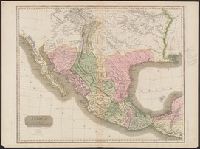
"Drawn & engraved for Thomson's New general atlas.", Appears in A new general atlas ... Edinburgh : John Thomson and Co., From the Streeter collection., In upper right margin: No. 58., and Relief shown by hachures.
Publisher:
John Thomson and Co.,
Subject (Geographic):
Central America--Maps and Mexico--Maps
Subject (Name):
Streeter, Thomas W.--(Thomas Winthrop),--1883-1965--Ownership and Thomson, John, geographer. New general atlas
"Drawn and engraved for Thomsons New general atlas, 1814.", From the Streeter collection., In upper right margin: No. 58., Library's copy annotated in pencil; one note questions whether this map is from the 1817 edition of Thomson's, and Relief shown by hachures.
Publisher:
John Thomson and Co.,
Subject (Geographic):
Central America--Maps and Mexico--Maps
Subject (Name):
Streeter, Thomas W.--(Thomas Winthrop),--1883-1965--Ownership and Thomson, John, geographer. New general atlas