Map showing the communication of the lakes and the rivers between Lake Superior and Slave Lake in North America
Description:
"Gent. Mag. March 1790, Pl. I, p. 197" in upper right hand corner., Mounted on linen. Sheet measures 20.7 x 24.3 cm. Cross Collection no. 178., Prime meridian: London., and Relief shown by hachures.
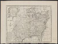
A new and accurate map of Louisiana, with part of Florida and Canada, and the adjacent countries
Description:
"No. 100.", "West longitude from London.", Appears in Bowen's A complete system of geography. 1752., Franklin Collection., Relief shown pictorially., and Sheet measures 40 x 53 cm.
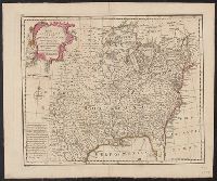
A new and accurate map of Louisiana, with part of Florida and Canada, and the adjacent countries
Description:
"No. 100.", "West longitude from London.", Appears in Bowen's A complete system of geography. 1752., Hand col. Mounted on linen. Sheet measures 41 x 49 cm. Verso: Stamped "W. Redmond Cross"., and Relief shown pictorially.
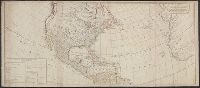
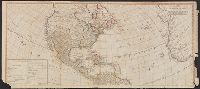
Includes table of "The continent and islands of America are divided and possessed as follows viz." and May be part of a map attributed to R. Sayer, based on maps by d'Anville and materials by Thomas Pownall; first issued in 1763 by J. Gibson and reissued over
Publisher:
s.n.,
Subject (Geographic):
NorthAmerica--Maps--Early works to
Subject (Name):
Anville, Jean Baptiste Bourguignon d', 1697-1782, Gibson, J. (John), and Pownall, Thomas, 1722-1805
Includes table of "The continent and islands of America are divided and possessed as follows viz.", Prime meridian: Ferro., and Probably part of a map attributed to R. Sayer, based on maps by d'Anville and materials by Thomas Pownall; first issued in 1763 by J.
Publisher:
s.n.,
Subject (Geographic):
NorthAmerica--Maps--Early works to
Subject (Name):
Anville, Jean Baptiste Bourguignon d', 1697-1782, Gibson, J. (John), and Pownall, Thomas, 1722-1805
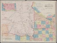
"Entered according to Act of Congress, in the year 1861 by B.M. Smith and A.J. Hill, in the Clerk's Office of the District Court for the District of Minnesota.", "Lith. by Louis Buechner, Saint Paul, Minnesota.", Inset: Outline map of Dakota Territory., and Shows counties and public lands township grid for eastern portion of Dakota Territory and for parts of Minnesota, Nebraska and Iowa, military reservations and outposts, Indian reservations, Indian treaty boundary lines, existing trails and wagon roads, proposed roads, historic routes of exploration, areas of Indian habitation, railroads, cities, and existing and proposed towns.
Publisher:
Louis Buechner
Subject (Geographic):
Dakota Territory--Maps, Iowa--Maps, Minnesota--Maps, and Nebraska--Maps
Subject (Name):
Buechner, Louis and Hill, A. J. (Alfred James), 1823-1895
The American military pocket atlas : being an approved collection of correct maps, both general and
Image Count:
1
Description:
Augst. 5th. 1776., Inset: A particular plan of Lake George. surveyed in 1756. By Capt. Jackson., and Teaching resource: Professor John Mack Faragher, History 141: The American West.
Publisher:
Printed for Robt. Sayer & Jno. Bennett, Map & Sea Chartsellers No. 53 Fleet Street, as the Act directs
Subject (Geographic):
NorthAmerica --Maps --Early works to
Collection Created:
London : Printed for R. Sayer and J. Bennet, [1776]
Hand colored., Relief shown pictorially., Shows "West longitude from London" and "from Philadelphia.", and Single sheet, uncolored, mounted on linen. Dimensions: 48 x 65 cm. Recto: Stamped "Yale Horace Brown 1900S".
Publisher:
Sold by T. Jefferys,
Subject (Geographic):
NorthAmerica--Maps--Early works to
Subject (Name):
Evans, Lewis, 1700?-1756, Jefferys, Thomas, d. 1771, and Mellon, Paul--Bookplate