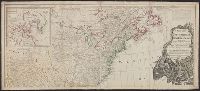
Copy 2: Imperfect: two southern sheets wanting. Borders hand colored. Dissected and mounted on linen, 50 x 115 cm. Stamp on verso, "Yale University Library, Karpinski-Von Wieser Map Collection.", Copy 2: Watermarks. Borders hand colored. Stamp on verso of northern sheets: 34. Stamp on verso of southern sheets: 35. Manuscript annotations in 20th century hand on verso of northern sheets., Insets: A particular map of Baffin and Hudson's Bay -- The passage by land to California., Prime meridians: London and Ferro., and Relief shown pictorially.
Publisher:
Publish'd by Laurie & Whittle, No. 53 Fleet Street,
Copy 1: two northern sheets joined and two southern sheets joined. Borders hand colored. Stamps, "Yale, Horace Brown, 1900S.", Copy 1: Watermarks. Borders hand colored. Stamp on verso of northern sheets: 62. Stamp on verso of southern sheets: 63., Insets: A particular map of Baffin and Hudson's Bay -- The passage by land to California., Prime meridians: London and Ferro., and Relief shown pictorially.
Publisher:
Publish'd by Laurie & Whittle, No. 53 Fleet Street,
Copy 3: Interiors hand colored. Stamp on verso of northern sheets: 37. Stamp on verso of southern sheets: 38., Insets: A particular map of Baffin and Hudson's Bay -- The passage by land to California., Prime meridians: London and Ferro., and Relief shown pictorially.
Publisher:
Publish'd by Laurie & Whittle, No. 53 Fleet Street,
Insets: A particular map of Baffin and Hudson's Bay -- The passage by land to California., Prime meridians: London and Ferro., Relief shown pictorially., and Yale's copy 1 joined on 2 sheets, 54 x 121 cm. and 54 x 120 cm.; coloring differs from copy 2; and stamp
Publisher:
Published by Laurie & Whittle, No. 53 Fleet Street,
Includes historical notes, text, and insets "A particular map of Baffin and Hudson's Bay" and "The passage by land to California, discover'd by Father Eusebius Francis Kino, a Jesuit; between the years 1698 and 1701, before which, and for a considerable t
Publisher:
Printed for Robt. Sayer, map, chart & printseller,
From George Henry Millar's New complete & universal system of geography. 1782., Inset map: "East Florida continued"., Recto: Numbered "166" (?) in ink ms. Verso: Stamped "Yale Horace Brown 1900S"., and Relief shown pictorially.
Publisher:
Engrav'd for Millar's New complete & universal system of geography,
Harbour of Annapolis Royal, Indian fort Sasquesahanok, and Map of ye mouth of Mississipi and Mobile rivers &c
Description:
Appears in Moll's The world described., Blocks of text offer explanations of various features of the map., Includes notes and ill. of "The Indian Fort Sasquesahanok.", Label, with ms. nos., on verso: 533/9. Hand col. Sheet measures, and Relief shown pictorially.
Publisher:
Sold by H. Moll over against Devereus Court between Temple Bar and St. Clements Church in the Strand ... [and] sold by Tho: Bowles ... Iohn King ... Iohn Bowles,
Subject (Geographic):
NorthAmerica--Maps--Early works to
Subject (Name):
Bowles, John, 1701-1779, bookseller, Bowles, Thomas, -1767, bookseller, and Moll, Herman, -1732. World described
Harbour of Annapolis Royal, Indian fort Sasquesahanok, and Map of ye mouth of Mississipi and Mobile rivers &c
Description:
Appears in Moll's The world described., Blocks of text offer explanations of various features of the map., Dedicated to Thomas Bromsall., Includes notes and ill. of "The Indian Fort Sasquesahanok.", and Insets: The harbour of Annapolis Royal -- A map of ye mouth
Publisher:
Sold by H. Moll over against Devereus Court between Temple Bar and St. Clements Church in the Strand ... [and] sold by Tho: Bowles ... Iohn King ... Iohn Bowles,
Subject (Geographic):
NorthAmerica--Maps--Early works to
Subject (Name):
Bowles, John, 1701-1779, bookseller, Bowles, Thomas, -1767, bookseller, and Moll, Herman, -1732. World described