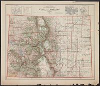
"Note: Medicine Bow National Forest now Colorado National Forest. Las Animas National Forest now part of San Isabel National Forest.", Insets: Leadville -- City of Denver -- Cripple Creek., Relief shown by shading., and Shows United States reclamation projects.
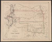
"Entered in Sta. Hall, London - & according to act of Congress in the year 1857 by H.D. Rogers, in the Clerks Office of the District Court of Massachusetts.", I, In top margin: Atlas of United States &c., 12., and Shows proposed Pacific Railway routes in purple.
Publisher:
John Murray ; and W. & A.K. Johnston,
Subject (Geographic):
Colorado--Maps, Indian Territory--Maps, and Kansas--Maps
Subject (Name):
John Murray (Firm), Johnston, Alexander Keith, 1804-1871, and Rogers, Henry D. (Henry Darwin), 1808-1866. Atlas of the United States of North America, Canada, New Brunswick, Nova Scotia, Newfoundland, Mexico, Central America, Cuba and Ja
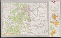
Includes 3 route maps., Map of "Colorado's topography as seen from 60 miles in the air," text, distance table, and photographs of recreational opportunities on verso., and Relief shown by spot heights.
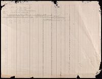
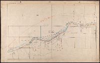
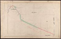
107 colored manuscript railroad maps, detailing the line of the Colorado Midland Railway between Park County and Pitkin and Garfield Counties. The highly detailed maps depict county ranges and townships, survey points and mileage markers, depots, canyons, bridges, sidings, trestles, tunnels, rivers, creeks, etc.; adjacent railroad lines and rights-of-way; hamlets, villages, settlements, ranches, farms, etc.; and plats of the towns of Buena Vista, Leadville, Glenwood Springs, and Aspen. Counties covered are Chaffee, Eagle, Garfield, Lake, Park, and Pitkin. Accompanied by an incomplete index (1 leaf) entitled "Valuation Section [?] Colo. Midland Ry" and two leaves of surveying notes.
Description:
Versos blank, not digitized.
Subject (Geographic):
Colorado--Maps and Garfield County (Colo.)--Maps
Subject (Name):
Colorado Midland Railway Company
Subject (Topic):
Mines and mineral resources--Colorado--Maps and Railroads--Colorado--Maps