
You Searched For
« Previous
| 1 - 10 of 17 |
Next »
Search Results
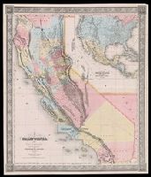
- Creator:
- Gibbes, Charles Drayton
- Published / Created:
- 1852
- Call Number:
- 844 1852A
- Container / Volume:
- BRBL_00601
- Image Count:
- 1
- Resource Type:
- Maps, Atlases & Globes
- Alternative Title:
- Gibbes' map of the state of California and Map of the United States of America, Mexico, Central America, Cuba &c.
- Description:
- Inset: Map of the United States of America, Mexico, Central America, Cuba &c. Scale [ca. 1:13,000,000] (W 128⁰--W 65⁰/N 49⁰--N 6⁰)., Presentation inscription: Charles D Gibbes [rubber stamped] to George Davidson, Jany 11/87., and Prime meridians: Greenwich and Washington.
- Publisher:
- C.D. Gibbes : and Sherman & Smith,
- Subject (Geographic):
- California--Maps
- Subject (Name):
- Davidson, George,--1825-1911.--Presentation inscription from C.D. Gibbes, Gibbes, Charles Drayton.--Presentation inscription to G. Davidson, and Sherman & Smith
- Found in:
- Beinecke Rare Book and Manuscript Library > A new map of California / by Charles Drayton Gibbes, from his own and other recent surveys and explorations.
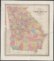
- Creator:
- Bonner, William G.
- Published / Created:
- 1853
- Call Number:
- 787 1853
- Container / Volume:
- BRBL_00516
- Image Count:
- 1
- Resource Type:
- Maps, Atlases & Globes
- Description:
- Hand-colored engraved map showing cities, roads, and railroads of the state of Georgia. and Prime meridian: Washington.
- Publisher:
- Wm. G. Bonner,
- Subject (Geographic):
- Georgia--Maps.
- Subject (Name):
- Sherman & Smith
- Found in:
- Beinecke Rare Book and Manuscript Library > Bonner's pocket map of the state of Georgia / compiled by Wm. G. Bonner, civil engineer, Milledgeville ; eng. by Sherman & Smith, N.Y.
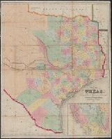
- Creator:
- Eppinger, J
- Published / Created:
- 1851
- Call Number:
- 796 1851A
- Container / Volume:
- BRBL_00525
- Image Count:
- 1
- Resource Type:
- Maps, Atlases & Globes
- Description:
- "Entered according to act of Congress in the year 1851 by Sherman & Smith in the clerks office of the district court for the southern district of New York.", Includes text and "Map of New Mexico, California, and Ut, Relief shown by hachures., and Shows counties.
- Publisher:
- s.n.],
- Subject (Geographic):
- Texas--Administrative and political divisions--Maps and Texas--Maps
- Subject (Name):
- Baker, F. C and Sherman & Smith
- Found in:
- Beinecke Rare Book and Manuscript Library > Map of Texas / compiled from surveys recorded in the General Land Office by J. Eppinger & F.C. Baker.
- Creator:
- Wilkes, Charles, 1798-1877
- Published / Created:
- [1845]
- Call Number:
- 80 1841B
- Container / Volume:
- BRBL_00533
- Image Count:
- 1
- Resource Type:
- Maps, Atlases & Globes
- Alternative Title:
- Columbia River, reduced from a survey made by the U.S. Ex. Ex.
- Description:
- Annotated in color ink to show boundaries, and dissected and mounted on linen., Appears in the author's Narrative of the United States Exploring Expedition ... 1845., Includes inset of "Columbia River, reduced from a survey made by the U.S. Ex. Ex., 1841" and text., and Relief shown by hachures.
- Publisher:
- J.H. Young : and Sherman & Smith,
- Subject (Geographic):
- Columbia River--Maps, Northwest, Pacific--Maps, and Oregon--Maps
- Subject (Name):
- Sherman & Smith, United States Exploring Expedition (1838-1842), and Young, J. H. (James Hamilton)
- Found in:
- Beinecke Rare Book and Manuscript Library > Map of the Oregon Territory / by the U.S. Ex. Ex., Charles Wilkes, 1841.

- Creator:
- Wilkes, Charles, 1798-1877
- Published / Created:
- [1845]
- Call Number:
- 80 1841B
- Container / Volume:
- BRBL_00533
- Image Count:
- 1
- Resource Type:
- Maps, Atlases & Globes
- Alternative Title:
- Columbia River, reduced from a survey made by the U.S. Ex. Ex.
- Description:
- Appears in the author's Narrative of the United States Exploring Expedition ... 1845., Includes inset of "Columbia River, reduced from a survey made by the U.S. Ex. Ex., 1841" and text., and Relief shown by hachures.
- Publisher:
- J.H. Young : and Sherman & Smith,
- Subject (Geographic):
- Columbia River--Maps, Northwest, Pacific--Maps, and Oregon--Maps
- Subject (Name):
- Sherman & Smith, United States Exploring Expedition (1838-1842), and Young, J. H. (James Hamilton)
- Found in:
- Beinecke Rare Book and Manuscript Library > Map of the Oregon Territory / by the U.S. Ex. Ex., Charles Wilkes, 1841.
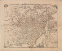
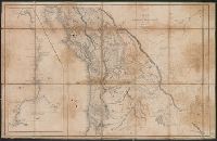
8.

- Creator:
- United States. Army. Corps of Topographical Engineers
- Published / Created:
- 1850 [i.e. 1851]
- Call Number:
- 80 1850D
- Container / Volume:
- BRBL_00534
- Image Count:
- 2
- Resource Type:
- Maps, Atlases & Globes
- Description:
- Date on map is 1850, however Wheat writes " ... ostensibly published in 1850, though it could not have gone to the engravers, Sherman and Smith of New York, until early in 1851" (Mapping the transmississippi West, 696)., On 2 sheets (each 62 x 105 cm.) and mounted on linen., and Relief shown by hachures.
- Publisher:
- Corps of Topographical Engineers],
- Subject (Geographic):
- West (U.S.)--Maps
- Subject (Name):
- Sherman & Smith
- Found in:
- Beinecke Rare Book and Manuscript Library > Map of the United States and their territories between the Mississippi and the Pacific Ocean, and of part of Mexico / compiled in the Bureau of the Corps of Topogl. Engs. under a resolution of the U.S. Senate, from the best authorities which could be obta
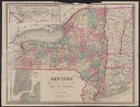
- Creator:
- Smith, J. Calvin (John Calvin)
- Call Number:
- 771 1858
- Container / Volume:
- BRBL_00479
- Image Count:
- 1
- Resource Type:
- Maps, Atlases & Globes
- Description:
- Also covers Vermont, Connecticut, and part of New Jersey, New Hampshire & Massachusetts., Includes legend., Insets: The St. Lawrence River, from the New York state line to Quebec -- City of New York, with part of Brooklyn and Williamsburgh., and Prime meridians:
- Publisher:
- J. Disturnell,
- Subject (Geographic):
- New York (State), New York (State)--Administrative and political divisions--Maps., and New York (State)--Maps.
- Subject (Name):
- Disturnell, John, 1801-1877 and Sherman & Smith
- Subject (Topic):
- Administrative and political divisions, Canals, Canals--New York (State)--Maps., Railroads, and Railroads--New York (State)--Maps.
- Found in:
- Beinecke Rare Book and Manuscript Library > Map of the state of New York, showing the boundaries of counties & townships, the location of cities, towns and villages, the courses of rail roads, canals & state roads / by J. Calvin Smith ; engraved on steel by Sherman & Smith.
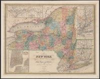
- Creator:
- Smith, J. Calvin (John Calvin)
- Call Number:
- 771 1842
- Container / Volume:
- BRBL_00478
- Image Count:
- 1
- Resource Type:
- Maps, Atlases & Globes
- Alternative Title:
- City of New York, with part of Brooklyn and Williamsburg, New-York State guide., St. Lawrence River, from the New York state line to Quebec, and Vicinity of New York, showing the line of the Croton Aqueduct and the Hudson River to Newburg
- Description:
- "Entered according to Act of Congress in the year 1842 by J. Calvin Smith in the Clerk's Office of the District Court of the southern District of New York." and In: The New-York State guide : containing an alphabetical list of counties, towns, cities, village
- Publisher:
- J. Disturnell,
- Subject (Geographic):
- Croton Aqueduct (N.Y.)--Maps., New York (N.Y.)--Maps, New York (State), New York (State)--Croton Aqueduct, New York (State)--Maps, New York (State)--New York, and North America--Saint Lawrence
- Subject (Name):
- Disturnell, John, 1801-1877 and Sherman & Smith
- Subject (Topic):
- Railroads and Railroads--New York (State)--Maps
- Found in:
- Beinecke Rare Book and Manuscript Library > Map of the state of New York, showing the boundaries of counties & townships, the location of cities, towns and villages, the courses of rail roads, canals & state roads / by J. Calvin Smith ; engraved on steel by Sherman & Smith.