North-American pilot for New England, New York, Pensilvania, Maryland, and Virginia.
Description:
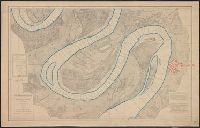
A Scale of 5 "English Miles" is given below the title at upper left., Below the scale: The Light-House of Sandy Hook is 40d. 27m. North Latitude., Coordinates not present on map and are approximated., Depths shown by soundings. Relief shown by hachures., First state., Includes note., Issued separately and in the first edition of Sayer & Bennett's North American Pilot for New England, New York, Pensilvania, Maryland, and Virginia. 1777., Sailing chart of the area around New York Harbor and Long Island; centered on Staten Island, York's Bay and Constable Point, extending north to Hells Gate, New York Island, Netwon Inlet, Bushwick Inlet, Wallabout Bay, Crown Point, the Battery and Ship Yards and south to the Shrewsbury River. The map extends East to include Amboy and the Raritan River, noting (Samuel?) Holland's House and east to Jamaica Bay and Plumb Island., and Watermarks.
Publisher:
Printed for Robt. Sayer & John Bennett, sea chart & map-sellers, No. 53, in Fleet Street. Published as the Act directs,
Subject (Geographic):
Atlantic Ocean--Lower Bay, Atlantic Ocean--Upper Bay, New Jersey--Sandy Hook, New York Harbor (N.Y. and N.J.) Maps--Early works to 1800., New York Region--Maps--Early works to 1800., and Sandy Hook (N.J.)
Subject (Name):
Robert Sayer and John Bennett (Firm), printmaker, printseller
Subject (Topic):
Nautical charts, Nautical charts--Hudson River Estuary (N.Y. and N.J.)--Early works to 1800., Nautical charts--Lower Bay (N.Y. and N.J.)--Early works to 1800., and Nautical charts--Upper Bay (N.Y. and N.J.)--Early works to 180
Backed with linen. River outline colored in blue; city of Greenville colored in red., Chart no. 39., Each sheet includes a list of authorities, note, and index chart.--Scale 1:360,000., Each sheet individually numbered, e.g.: Chart No.1, Chart No.2., Projected from a trigonometrical survey made in 1879-'80., and Relief shown by contours. Depths shown by soundings.
Publisher:
Mississippi River Commission,
Subject (Geographic):
Mississippi River and Mississippi River--Maps
Subject (Topic):
Nautical charts and Nautical charts--Mississippi River--Maps.
The West-India atlas: or, A compendious description of the West-Indies: illustrated with forty
Image Count:
1
Resource Type:
Maps, Atlases & Globes
Alternative Title:
The harbours of Kingston and Port Royal and The windward passage, with the several passages, from the...east end of Cuba, and the north part of St. Domingo.
Description:
With two inset maps.
Subject (Geographic):
Cuba. and Santo Domingo (Dominican Republic)
Subject (Topic):
Nautical charts
Collection Created:
London, Printed for Robert Sayer and John Bennett, Fleet-Street, 1775