- Creator:
- Jefferys, Thomas, d. 1771
- Published / Created:
- 1st January 1789.
- Call Number:
- 655 1789
- Container / Volume:
- BRBL_00345
- Image Count:
- 1
- Resource Type:
- Maps, Atlases & Globes
- Description:
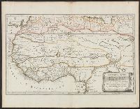
- "This map is copied from an original drawn by Monsr. D'Anv, Also appeared in Kitchin's General atlas describing the whole universe. London : Printed for Robert Sayer, [1780]., Prime meridians: Ferro and London., and Relief shown pictorially; depths by soundings.
- Publisher:
- Printed for Robert Sayer,
- Subject (Geographic):
- Africa, West--Maps--Early works to 1800
- Subject (Name):
- Abbot, Charles,--Baron Colchester,--1757-1829--Bookplate, Anville, Jean Baptiste Bourguignon d', 1697-1782, Kitchin, Thomas, d. 1784. General atlas describing the whole universe, and Robert Laurie and James Whittle
- Subject (Topic):
- Coasts--Africa, West--Maps--Early works to 1800
- Found in:
- Beinecke Rare Book and Manuscript Library > The western coast of Africa, from Cape Blanco to Cape Virga, exhibiting Senegambia proper / by T. Jefferys.
You Searched For
« Previous
| 1 - 10 of 18 |
Next »
Search Results
- Creator:
- Jefferys, Thomas, d. 1771
- Published / Created:
- August 12th, 1768.
- Call Number:
- 655 1768
- Container / Volume:
- BRBL_00345
- Image Count:
- 1
- Resource Type:
- Maps, Atlases & Globes
- Description:
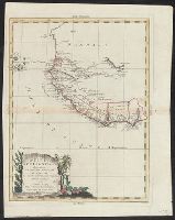
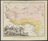
- "This map is copied from an original drawn by Monsr. D'Anville ... & published at Paris in 1751. But since the Peace of 1762, that map has been supressed [sic] ... ", Includes descriptive notes,, Prime meridians: Ferro and London., and Relief shown pictorially.
- Publisher:
- Printed for Robert Sayer in Fleet Street & Thomas Jefferys in the Strand,
- Subject (Geographic):
- Africa, West--Maps--Early works to 1800, Coasts--Africa, West--Maps--Early works to 1800, and Gambia--Colonization--Maps--Early works to 1800
- Subject (Name):
- Anville, Jean Baptiste Bourguignon d', 1697-1782 and Sayer, Robert, 1725-1794
- Found in:
- Beinecke Rare Book and Manuscript Library > The western coast of Africa, from Cape Blanco to Cape Virga, exhibiting Senegambia proper / by T. Jefferys.
- Creator:
- Fries, Lorenz, ca. 1490-1531
- Published / Created:
- 1541?]
- Call Number:
- 655 1541
- Container / Volume:
- BRBL_00345
- Image Count:
- 1
- Resource Type:
- Maps, Atlases & Globes
- Alternative Title:
- Tabula nova partis Africae
- Description:
- Covers western and northern Africa., Includes ill., On verso: 38., Relief shown pictorially., and Watermark: Bunch of grapes.
- Publisher:
- J. Grüninger?,
- Subject (Geographic):
- Africa, North--Maps--Early works to 1800 and Africa, West--Maps--Early works to 1800
- Found in:
- Beinecke Rare Book and Manuscript Library > Tabula noua partis Africae.
- Creator:
- Keulen, Johannes van, 1654-1715
- Published / Created:
- [between 1681 and 1696?]
- Call Number:
- 655 1681
- Container / Volume:
- BRBL_00345
- Image Count:
- 1
- Resource Type:
- Maps, Atlases & Globes
- Description:
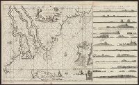
- "By Joannes van Keulen, Boek-vercooper en graadboog maecker, by de nieuwe brugh in de gecroonde Lootsman.", "Met prevelegie voor 15 Jaer.", Covers coastal West Af, Depths shown by soundings., Has watermarks., In lower right: 2., and Oriented with north to the left.
- Publisher:
- Joannes van Keulen,
- Subject (Geographic):
- Africa, West--Maps--Early works to 1800 and Africa, West--Nautical charts--Early works to 1800
- Subject (Topic):
- Coasts--Africa, West--Maps--Early works to 1800 and Nautical charts--Africa, West--Early works to 1800
- Found in:
- Beinecke Rare Book and Manuscript Library > Pas caarte van Rio Gambia, van C. Verde tot Rio de Serraliones.
- Creator:
- Ogilby, John, 1600-1676
- Published / Created:
- 1670]
- Call Number:
- 655 1670A
- Container / Volume:
- BRBL_00345
- Image Count:
- 1
- Resource Type:
- Maps, Atlases & Globes
- Description:
- From Ogilby's Africa, being an accurate description of the regions of Egypt, Barbary, Lybia and Billedulgerid. 1670., Has watermarks., Includes ill. and decorative cartouche., and Relief shown pictorially.
- Publisher:
- Printed by T. Johnson for the author,
- Subject (Geographic):
- Africa, Central--Maps--Early works to 1800 and Africa, West--Maps--Early works to 1800
- Subject (Name):
- Ogilby, John, 1600-1676. Africa, being an accurate description of the regions of Egypt, Barbary, Lybia and Billedulgerid
- Found in:
- Beinecke Rare Book and Manuscript Library > Nigritarum regio.
- Creator:
- Zatta, Antonio, fl. 1757-1797
- Published / Created:
- 1784
- Call Number:
- 655 1784
- Container / Volume:
- BRBL_00345
- Image Count:
- 1
- Resource Type:
- Maps, Atlases & Globes
- Description:
- "Con privilegio dell'Eccmo. Senato." and Relief shown pictorially.
- Publisher:
- Presso Antonio Zatta e Figli,
- Subject (Geographic):
- Africa, West--Maps--Early works to 1800
- Subject (Name):
- Pitteri, Giovanni Marco, 1702-1786
- Found in:
- Beinecke Rare Book and Manuscript Library > La Guinea occidentale : che contiene le isole di Capo Verde, il Senegal, la costa propriamente detta della Guinea / G. Pitteri scr.
7.
- Creator:
- Sanson, Nicolas, 1600-1667
- Published / Created:
- 1655
- Call Number:
- 655 1655
- Container / Volume:
- BRBL_00345
- Image Count:
- 1
- Resource Type:
- Maps, Atlases & Globes
- Description:
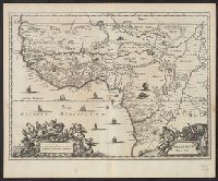
- "Avec privilege du Roy, pour vingt ans.", "La coste des Negres, et Guinee, &c. est apres les observations de Samuel Blomart.", Has watermark., Relief shown pictorially., and Verso: numbered "24" in ink in upper right corner.
- Publisher:
- Chez Pierre Mariette, rue St. Iacques a l'Esperance,
- Subject (Geographic):
- Africa, North--Maps--Early works to 1800 and Africa, West--Maps--Early works to 1800
- Subject (Name):
- Blomart, Samuel and Somer Pruthenus, I
- Found in:
- Beinecke Rare Book and Manuscript Library > L'Afrique, ou Libie ulterieure : ou sont le Saara, ou desert, le pays des Negres, la Guinee, et les pays circonv. tirée en partie de Sanut, et de l'Arabe de Nubie, en partie de diverses cartes veües jusques a present / par le S. Sanson d'Abbeville, geog
8.
- Creator:
- Homann Erben (Firm)
- Published / Created:
- 1743
- Call Number:
- 655 1743
- Container / Volume:
- BRBL_00345
- Image Count:
- 1
- Resource Type:
- Maps, Atlases & Globes
- Alternative Title:
- Guinea propria, nec non Nigritiæ vel Terræ Nigrovrm maxima pars, Guinee de meme que la plus grande partie du Pais des Negres, and Gvinee de meme que la plus grande partie du Pais des Negres
- Description:
- Covers West Africa from Gabon in the south to Niger, Mali, and Mauritania in the north., Has watermark., Includes indexed ill. depicting the dress, dwellings, and work of native Africans., Prime meridian: Ferro., and Relief shown pictorially.
- Publisher:
- Homannianorum Heredum,
- Subject (Geographic):
- Africa, West--Maps--Early works to 1800
- Subject (Name):
- Anville, Jean Baptiste Bourguignon d', 1697-1782 and Marchais, R. de
- Found in:
- Beinecke Rare Book and Manuscript Library > Gvinea propria, nec non Nigritiæ vel Terrae Nigrorvm maxima pars : geographis hodiernis dicta utraq[ue] Aethiopia inferior, & hujus quidem pars australis / ex delineationibus Anvillianis itineri guineensi D. de Marchais insertis secundum leges projectioni
- Creator:
- Mercator, Gerhard, 1512-1594
- Published / Created:
- 1628]
- Call Number:
- 655 1628
- Container / Volume:
- BRBL_00345
- Image Count:
- 2
- Resource Type:
- Maps, Atlases & Globes
- Alternative Title:
- Gvineae nova descriptio
- Description:
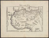
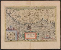
- From the author's Gerardi Mercatoris atlas. 1628., Inset: I. S. Thomae., Map text in Latin. Text on verso in French., Relief shown pictorially., and Text on verso titled "Guinee, avec les isles de S. Thomas, du Prince, et d'Anobon," p. 637 and 640.
- Publisher:
- Sumptibus & typis aeneis Henrici Hondij,
- Subject (Geographic):
- Africa, West--Maps--Early works to 1800
- Subject (Name):
- Hondius, Hendrik, 1597-1651 and Mercator, Gerhard, 1512-1594. Gerardi Mercatoris Atlas
- Found in:
- Beinecke Rare Book and Manuscript Library > Guineae nova descriptio.
10.
- Creator:
- Ogilby, John, 1600-1676
- Published / Created:
- 1670]
- Call Number:
- 655 1670
- Container / Volume:
- BRBL_00345
- Image Count:
- 1
- Resource Type:
- Maps, Atlases & Globes
- Alternative Title:
- Gvinea
- Description:
- Covers coastal western and central Africa from Sierra Leone to Gabon., From Ogilby's Africa, being an accurate description of the regions, Includes ill. and decorative cartouche., Relief shown pictorially., and Verso: stamped "Map Collection Yale Univ. Library".
- Publisher:
- Printed by T. Johnson for the author,
- Subject (Geographic):
- Africa, Central--Maps--Early works to 1800 and Africa, West--Maps--Early works to 1800
- Subject (Name):
- Ogilby, John, 1600-1676. Africa, being an accurate description of the regions of Egypt, Barbary, Lybia and Billedulgerid
- Subject (Topic):
- Coasts--Africa, Central--Maps--Early works to 1800 and Coasts--Africa, West--Maps--Early works to 1800
- Found in:
- Beinecke Rare Book and Manuscript Library > Guinea.