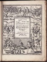
Signed and dated holograph manuscript reports in French by Beaumont de Brivazac concerning French interests in America. Twelve reports written between December 1817 and May 1819, document and analyze the political, diplomatic, and economic affairs of...
Description:
Louis C. Hubert, called Comte de Beaumont de Brivazac, was an espionage agent for Louis XVIII, and submitted secret diplomatic reports to Elie Decazes while living in London. He published a work entitled L'europe et ses colonies en decembre 1819, con...
Subject (Geographic):
England., France., Arctic regions, Northwest Passage, Canada, Great Britain, Spain, America, United States, France, and South America
Subject (Name):
Buchan, Captain., Beaumont de Brivazac, comte de, 1746-1821., and Ross, John, Sir, 1777-1856.
Subject (Topic):
Espionage, Spies, Discovery and exploration, British, Politics and government, Foreign relations, Colonies, and History
Land grant, manuscript on parchment, originally made to Alonzo Prieto, and awarded after his death to his brother Gonzalo Prieto, following litigation. The grant, valued at 35,000 maravedis annually, was given to defray the costs of preparing land and...
Description:
In Spanish.
Subject (Geographic):
Spain, Jerez de la Frontera., Connecticut, New Haven., Jerez de la Frontera (Spain), and America
Subject (Name):
Charles V, Holy Roman Emperor, 1500-1558.
Subject (Topic):
Land grants, Land titles, Manuscripts, Medieval, Colonies, History, and Politics and government
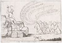
"The five commissioners (right) recently nominated to negotiate peace with the colonies, kneel one behind the other at the feet of America, who sits (left) on a pile of barrels and bales looking away from the Commissioners at a cap of liberty which sh...
Description:
Title from item.
Publisher:
Pubd. April 1, 1778 by M. Darly 39 Strand
Subject (Geographic):
United States, Great Britain, and America
Subject (Name):
Howe, William Howe, Viscount, 1729-1814., Howe, Richard Howe, Earl, 1726-1799., Carlisle, Frederick Howard, Earl of, 1748-1825., Auckland, William Eden, Baron, 1744-1814., and Johnstone, George, 1730-1787.
Subject (Topic):
History, Causes, Colonies, Economic policy, Clothing & dress, and Liberty cap
Drawing in red chalk on hand-ruled paper by an unidentified artist, of the decorative cartouche for John Mitchell's Map of the British and French dominions in North America. Represented in the drawing are two Native American figures in the lower right...
Description:
John Mitchell (1711-1768), was a British botanist, physician, and cartographer. He created A Map of the British and French dominions in North America (London: Andrew Millar, 1755), also known as the Mitchell Map, later used in negotiating the 1783 Tre...