From his atlas Prospect of the World, pp. 9-10, sig. e, catch. in-., Includes text, inset of Greenland, and views of towns and ill. of figures in margins., Text of "The description of America" on verso., and Tooley identifies this as a 1676 issue, noting NY and Maryland mentioned for the first time in text about Virginia (section 14) on verso; and Hochelaga, Quebec, and Tadasac added to description of Canada.
Publisher:
are to be sold by Thomas Bassett in Fleet Street and by Richard Chiswell in St. Pauls Churchyard,
Subject (Geographic):
America--Maps--Early works to 1800.
Subject (Name):
Bassett, Thomas, bookseller., Chiswell, Richard., Goos, Abraham, engraver., and Speed, John, 1552?-1629. Prospect of the most famous parts of the world.
America. pars 4. Latin, Americae pars qvarta, Insignis & admiranda historia, and Insignis et admiranda historia
Description:
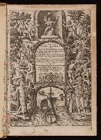
2nd. ed. Cf. Chruch. T.p. signed: A.E. Arabic numbers on plates. Plate XI with catchword "Indi.", Engraved t.p., Imperfect: wormed with some loss of text. Map (32 x 43 cm, on sheet 34 x 45 cm) bound following leaf R6., Includes Urbain Chauveton's Latin translation of bk. 1 of Benzoni's Historia del Mondo Nuovo, with additional notes., Map: Occidentalis Americae partis, vel earum regionium quas Christophorus Columbus primu[m] detexit ... praesertim verò ex Hieronyni Benzoni (qui totis XIIII annis eas provincias diligenter perlustravit) historia, conflata & in aes incisa à Theodoro de Bry Leod' anno MDXCIIII. Scale not given., and Signatures: 2):(⁴, ²2):(⁴, A-Q⁴ R⁶, ²A-E⁴ F⁶ (R6, ²F6 blank)
Publisher:
Typis Ioannis Feyrabend : Impensis Theodori de Bry,
Subject (Geographic):
America--Discovery and exploration--Maps--Early works to 1800., America--Discovery and exploration--Spanish--Early works to 1800., America--Early accounts to 1600., America--Maps--Early works to 1800., Latin America--Description and travel--Early works to 1800., Latin America--History--To 1600., and Latin America--Maps--Early works to 1800.
Subject (Name):
Benzoni, Girolamo, 1519-1572? Historia del Mondo Nuovo. Book 1. Latin., Bry, Theodor de, 1528-1598., Chauveton, Urbain, -approximately 1616., and Feyerabend, Johann, 1550-1599, printer.
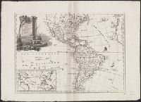
Armenian., Includes inset of northern North America and col. ill., Inscription in upper right: Yale College Library, from Professor E.E. Salisbury, 1870., and Relief shown pictorially.
Publisher:
I Vans Srboyn Ghazaru,
Subject (Geographic):
America--Maps--Early works to 1800.
Subject (Name):
Mkhitʻarean Miabanutʻiwn i Venetik and Salisbury, Edward Elbridge,--1814-1901--Ownership.
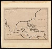
Appears in French eds. of Herrera y Tordesilla's Descripción de las Indias Occidentales published in Amsterdam., Sheet measures 28.7 x 35.2 cm. Cross Collection no. 227., and Shows coasts of the southern part of North America, Central America, northern coast of South America, and West Indies.
Publisher:
Michiel Colijn,
Subject (Geographic):
America--Maps--Early works to 1800., Central America--Maps--Early works to 1800., and West Indies--Maps--Early works to 1800.
Subject (Name):
Colijn, Michiel, publisher. and Herrera y Tordesillas, Antonio de, -1625. Descripción de las Indias Occidentales. French.
Engraved t.-p., within ornamental border., Errata: p. [1] at end., Imperfect: 2 p.l. and first map, "Orbis terrarum," wanting; autograph of Amadeus Canalius; unidentified bookplate: Sc. 8. D N. 28., and Signatures: [*]⁴ A-Aa⁴.
Publisher:
Tijpis Iohannis Bogardi,
Subject (Geographic):
America--Discovery and exploration., America--Early accounts to 1600., and America--Maps--Early works to 1800.
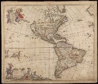
"Cum Privilegio D.D. Ordinum Holl. Westfriliegs.", According to P.D. Burden, Mapping of North America, this is the seventh state of de Wit's map of America, with a new title engraved adding the privilege statement, lower case letters inserted between the latitude numbers and upper case letters between the longitude, and the longitudinal line 338° bearing a bad plate crack in the souther hemipshere, with an erased compass rose at the junction of 338° longitude and 10° north latitude., Appears in various editions of Wit's Atlas., Baked with paper., Number "2" in upper right corner., Prime meridian: Ferro., Relief shown pictorially., and Watermark.
Subject (Geographic):
America--Maps--Early works to 1800. and Western Hemisphere--Maps--Early works to 1800.