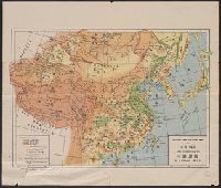
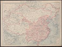
Insets: Canton und Umgebung, 1:2,000,000 -- Asien: Volksdichte, 1:80,000,000 -- Hauptzufahrtswege nach China -- Asien: Völker -- Umgebung von Peking, 1:1,500,000 -- Plan von Peking -- Landes-Hauptstadt, 1:7,500,000 -- Kiau-Tschou-Gebeit.
Its A.M.S. ; 5207 and Series (Standard map series designation system) ; S901.
Description:
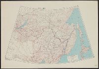
"9-45.", "Lambert conformal conic projection.", Area covered extends from Lake Baikal to the Pacific Ocean and includes Manchuria., Elevations are shown by hachures and spot heights in meters., and Two classes of roads and five classes of railroads are shown.
Publisher:
Army Map Service,
Subject (Geographic):
Asiatic Russia--Maps, China--Maps, and Russia--Maps
Subject (Topic):
Transportation--China--Manchuria--Maps and Transportation--Russia--Maps
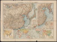
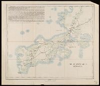
"The London Geographical Institute, M.C.H.", Includes inset maps of Taiwan (Formosa) and Karafuto (Sakhalin), same scale., and Shows Japan, Korea, and the eastern coast of China, railways, air routes, and shipping routes.
"The London Geographical Institute, M.C.H.", Includes inset maps of Taiwan (Formosa) and Karafuto (Sakhalin), same scale., and Shows Japan, Korea, and the eastern coast of China, railways, air routes, and shipping routes.