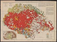
- Creator:
- Teleki, Pál, gróf, 1879-1941
- Published / Created:
- 1919
- Call Number:
- 11hcf 1919-51
- Container / Volume:
- BRBL_00010L
- Image Count:
- 1
- Resource Type:
- Maps, Atlases & Globes
- Alternative Title:
- Carte ethnographique de la Hongrie construite en la accordance avec la densité de la population and Ethnographical map of Hungary based on the density of population
- Description:
- "Every square millimeter coloured indicates 100 inhabitants. According to the census of 1910.", Imperfect. text and leaf wanting. Copy 2 mounted on linen., In English, Hung, and Includes 1 inset map showing area around Budapest, sclae 1:5,000,000.
- Publisher:
- Hungarian Geographical Institut,
- Subject (Geographic):
- Carpathian Mountains Region--Maps, Czechoslovakia--Maps, Hungary--Maps, Romania--Romania--Transylvania--Maps, Yugoslavia--Maps, and Zakarpatsʹka oblastʹ (Ukraine)--Maps
- Subject (Topic):
- Ethnolo, Ethnology--Carpathian Mountains Region--Maps, Ethnology--Czechoslovakia--Maps, Ethnology--Hungary--Maps, Ethnology--Romania--Transylvania--Maps, and Ethnology--Ukraine--Zakarpatsʹka oblastʹ--Maps
- Found in:
- Beinecke Rare Book and Manuscript Library > Magyarország néprajzi térképe a népsürüség alapján = / szerkesztette Grof Teleki Pál = Ethnographical map of Hungary based on the density of population / by Count Paul Teleki = Carte ethnographique de la Hongrie construite en la accordance avec