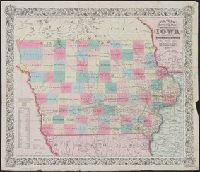
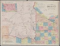
Colton, G. Woolworth (George Woolworth), 1827-1901
Published / Created:
1862
Call Number:
754gme 1860A
Container / Volume:
BRBL_00420
Image Count:
1
Resource Type:
Maps, Atlases & Globes
Alternative Title:
Colton's county and township railroad map of Wisconsin, Illinois, Missouri, & Iowa, County and township rail road map of Wisconsin, Illinois, Missouri, & Iowa, and Wisconsin, Illinois, Missouri, & Iowa
Description:
"Entered according to Act of Congress by Thayer & Colton in the Clerk's office of the District Court of the United States for the Southern District of New York in t
Publisher:
Drawn, engraved & published by G. Woolworth Colton; and Rufus Blanchard,
Subject (Geographic):
Illinois--Maps, Iowa--Maps, Missouri--Maps, and Wisconsin--Maps
Subject (Name):
Blanchard, Rufus, 1821-1904
Subject (Topic):
Railroads--Illinois--Maps, Railroads--Iowa--Maps, Railroads--Missouri--Maps, and Railroads--Wisconsin--Maps
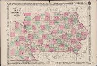
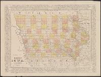
Iowa and Nebraska and Johnson's new illustrated family atlas of the world.
Description:
"Entered according to act of Congress in the year 1864 by A.J. Johnson in the clerks office of the district court of the United States for the southern district of New York."
"Entered according to Act of Congress, in the year 1861 by B.M. Smith and A.J. Hill, in the Clerk's Office of the District Court for the District of Minnesota."
Publisher:
Louis Buechner
Subject (Geographic):
Dakota Territory--Maps, Iowa--Maps, Minnesota--Maps, and Nebraska--Maps
"Entered according to Act of Congress, in the year 1861 by B.M. Smith and A.J. Hill, in the Clerk's Office of the District Court for the District of Minnesota."
Publisher:
Louis Buechner
Subject (Geographic):
Dakota Territory--Maps, Iowa--Maps, Minnesota--Maps, and Nebraska--Maps
Subject (Name):
Buechner, Louis and Hill, A. J. (Alfred James), 1823-1895
Subject (Topic):
Cities and towns--Dakota Territory--Maps, Discoveries in geography--Maps, Indian reservations--Dakota Territory--Maps, Indian reservations--Nebraska--Maps, Indians of North America--Maps, and Military bas
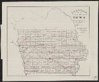
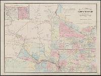
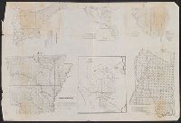
Arkansas., Diagram of the surveying district south of Tennessee., Map of the district north of Red River and part of N.W. District, LA., Map of the southwestern district, Louisiana., Sketch of the public surveys in Iowa Territory., and South eastern district Louis
Description:
At top of Arkansas map: A(1).
Publisher:
s.n.,
Subject (Geographic):
Arkansas--Maps, Iowa--Maps, Louisiana--Maps, and Mississippi--Maps
"Entered according to act of Congress in the year 1856 by Charles W. Morse in the clerk's office of the district court of the United States for the southern district of New York."