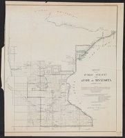
Surveyor General of Iowa, Wisconsin, and Minnesota
Published / Created:
1855
Call Number:
812 1855C
Container / Volume:
BRBL_00555
Image Count:
1
Resource Type:
Maps, Atlases & Globes
Alternative Title:
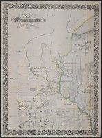
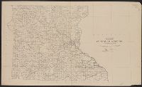
No. 1, Sketch of public surveys in Wisconsin and territory of Minnesota.
Description:
"Surveyor General's Office, Dubuque, October 21st 1855, Warner Lewis.", At head of title: (No. 1)., Blindstamps of Columbia College Library, N, Coordinates not present on map and are approximated., and Sen. Ex. Doc. No. 1, 54th Cong., 1st Sess.
Publisher:
Surveyor General's Office,
Subject (Geographic):
Minnesota--Maps, Minnesota--Surveys--Maps, Wisconsin--Maps, and Wisconsin--Surveys--Maps
Subject (Name):
A. Hoen & Co, Columbia College (New York, N.Y.). Library Stamp, and Lewis, Warner, 1805-1888
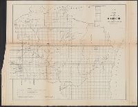
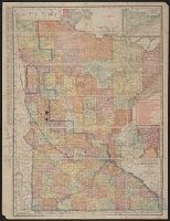
No. 1, Sketch of public surveys in Wisconsin and territory of Minnesota.
Description:
"Surveyor General's Office, Dubuque, October 10th, 1860, Warner Lewis.", At head of title: (No. 1), Includes legend., and Sen. Ex. Doc. No. 1, 2nd Sess. 36th Cong.
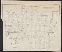
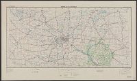
"Work Projects Administration project. Prepared under the direction of the Chief of Engineers, U.S. Army, by Engineer Reproduction Plant, the Army War College.", Coverage includes portions of Minnesota and Wisconsin., and Shows up to 7 classes of roads, 3 classes of railroads, and 4 classes of airfields.
Publisher:
Army Map Service,
Subject (Geographic):
Minnesota--Maps and Wisconsin--Maps
Subject (Name):
United States. Army Map Service and United States. Work Projects Administration
Subject (Topic):
Transportation--Minnesota--Maps and Transportation--Wisconsin--Maps
annotated in color pencil; verso index covered by backing., Includes insets of "N.E. corner of Minnesota, showing Cook Co." and "Minneapolis, St. Paul and vicinity.", Indexed on verso., and Shows railroads, counties, townships, etc.