Skip to search
Skip to main content
Skip to first result
Search
You Searched For
Subject (Geographic)
North America--Maps--Early works to 1800
Search Results
Creator:
Published / Created:
[1796?]
Call Number:
71 1795
Container / Volume:
BRBL_00367
Image Count:
1
Resource Type:
Maps, Atlases & Globes
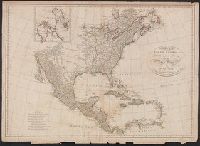
Description:
Appears in Winterbotham's The American atlas ... New York : J. Reid, 1796.
Publisher:
John Reid,
Subject (Geographic):
North America--Maps--Early works to 1800
Subject (Name):
Reid, John, 1764?-1828 and Winterbotham, William, 1763-1829. American atlas .
Found in:
Beinecke Rare Book and Manuscript Library > A general map of North America : drawn from the best surveys, 1795 / Scoles sc.
Creator:
Published / Created:
[1778?]
Call Number:
BrSides 2017 62
Image Count:
1
Resource Type:
Maps, Atlases & Globes
Description:
Includes distance chart.
Publisher:
[publisher not identified],
Subject (Geographic):
North America--Maps--Early works to 1800
Subject (Name):
Jefferys, Thomas, -1771.
Found in:
Beinecke Rare Book and Manuscript Library > A general map of North America ; from the latest observations / engrav'd by Jno. Lodge from the late Mr. Jefferys, geographer to the King.
Creator:
Published / Created:
1758
Call Number:
755 1758
Container / Volume:
BRBL_00428
Image Count:
1
Resource Type:
Maps, Atlases & Globes
Alternative Title:
Middle British colonies
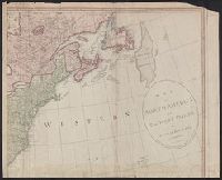
Description:
Hand colored.
Publisher:
Sold by T. Jefferys,
Subject (Geographic):
North America--Maps--Early works to 1800 and Northeastern States--Maps--Early works to 1800
Subject (Name):
Evans, Lewis, 1700?-1756, Jefferys, Thomas, d. 1771, and Mellon, Paul--Bookplate
Subject (Topic):
British--America--Maps--Early works to 1800
Found in:
Beinecke Rare Book and Manuscript Library > A general map of the middle British colonies in America : viz. Virginia, Maryland, Delaware, Pensilvania, New-Jersey, New-York, Connecticut and Rhode-Island : of Aquanishuonigy the country of the confederate Indians comprehending Aquanishuonigy proper, th
Creator:
Published / Created:
1765
Call Number:
71 1765
Container / Volume:
BRBL_00364
Image Count:
1
Resource Type:
Maps, Atlases & Globes
Description:
"Longit. west from Ferro I."
Publisher:
Printed for John Bowles,
Subject (Geographic):
North America--Maps--Early works to 1800
Subject (Name):
Bowles, Carington, 1724-1793, Bowles, John, 1701-1779, and Palairet, Jean, 1697-1774
Subject (Topic):
British--America--Maps--Early works to 1800
Found in:
Beinecke Rare Book and Manuscript Library > A map of North America / by J. Palairet, with considerable alterations & improvements from d'Anville, Mitchell & Bellin, by L. Delarochette.
Creator:
Published / Created:
17--?]
Call Number:
71 1769A
Container / Volume:
BRBL_00364
Image Count:
1
Resource Type:
Maps, Atlases & Globes
Description:
Includes text and inset of Hudson and Baffin bays.
Publisher:
s.n.,
Subject (Geographic):
North America--Maps--Early works to 1800
Found in:
Beinecke Rare Book and Manuscript Library > A map of North America : from D'Anville, 1769.
Creator:
Published / Created:
1791?]
Call Number:
71 1791
Container / Volume:
BRBL_00367
Image Count:
1
Resource Type:
Maps, Atlases & Globes
Description:
In upper right margin: 21.
Publisher:
John Harrison?,
Subject (Geographic):
North America--Maps--Early works to 1800
Subject (Name):
Anville, Jean Baptiste Bourguignon d', 1697-1782
Found in:
Beinecke Rare Book and Manuscript Library > A map of North America : published under the patronage of the Duke of Orleans by d'Anville / drawn and engraved for J. Harrison, No. 115 Newgate Street, January 1, 1791.
Creator:
Published / Created:
1745?]
Call Number:
71 1746
Container / Volume:
BRBL_00362
Image Count:
1
Resource Type:
Maps, Atlases & Globes
Description:
From the Streeter collection.
Publisher:
s.n.,
Subject (Geographic):
North America--Maps--Early works to 1800
Subject (Name):
Streeter, Thomas W.--(Thomas Winthrop),--1883-1965--Ownership
Found in:
Beinecke Rare Book and Manuscript Library > A map of North America : with the European settlements & whatever else is remarkable in ye West Indies, from the latest and best observations / R.W. Seale, delin. et sculp.
Creator:
Published / Created:
1st of March 1789.
Call Number:
71 1789
Container / Volume:
BRBL_00366
Image Count:
4
Resource Type:
Maps, Atlases & Globes
Description:
Copy 1: Stamped on verso: Yale, Horace Brown, 1900s.
Publisher:
Robt. Wilkinson at No. 58 in Cornhill,
Subject (Geographic):
North America--Maps--Early works to 1800
Subject (Name):
Wilkinson, Robert, -approximately 1825
Found in:
Beinecke Rare Book and Manuscript Library > A map of North America and the West Indies / by L.S. de la Rochette.
Creator:
Published / Created:
176-?]
Call Number:
71 1760B
Container / Volume:
BRBL_00364
Image Count:
1
Resource Type:
Maps, Atlases & Globes
Description:
Annotated in pencil: 1769, from Blair's Chronology.
Publisher:
s.n.,
Subject (Geographic):
North America--Maps--Early works to 1800
Subject (Name):
Kitchin, Thomas, d. 1784
Found in:
Beinecke Rare Book and Manuscript Library > A map of North America, from the latest surveys and maps / by John Blair as a supplement to his Tables of chronology ; Thos. Kitchin, sculpsit.
Creator:
Published / Created:
1733
Call Number:
89 1720
Container / Volume:
BRBL_00697
Image Count:
1
Resource Type:
Maps, Atlases & Globes
Alternative Title:
America Septentrionalis., Sir Charles Wager's engagement with the fleet of Spanish men of war and galeons off of Cartagena., and Sr. Charles Wager's engagement with the fleet of Spanish men of war and galeons off of Cartagena.
Description:
"C. Lemprière, inv. & del., B. Baron, sculp." cf. plate 17.
Publisher:
Sold by S. Harding ... and by W.H. Toms, engraver ...,
Subject (Geographic):
Great Britain--Colonies--America--Maps--Early works to 1800 and North America--Maps--Early works to 1800
Subject (Name):
Baron, Bernard, 1696-1762, Harding, S., fl. 1724-1741, Lemprière, Clement, and Toms, W. H. (William Henry), approximately 1700-approximately 1750
Found in:
Beinecke Rare Book and Manuscript Library > A map of the British Empire in America, with the French and Spanish settlements adjacent thereto / by Henry Popple.